I had a chance to spend a few days on the San Rafael River at the end of July. I went in on Monday and returned Wednesday evening. I was alone, so it was an out and back hike to Fuller Bottom, starting and ending at the San Rafael River bridge, about 15 miles each way. I looked up a few side canyons although conditions and time didn’t allow for much exploration. I will definitely need to go back. The walking was easy, the “trails” fairly clear and not too brushy, and it wasn’t terribly hot even though the forecast was calling for temps over 100 degrees.
I traveled light as usual foregoing even a sleeping bag this trip, taking a Golite nest for bugs and an Integral Designs Ultralight Bivy Sack and silcloth poncho. All in all these were good choices. Of course I had the usual backup lightweight ploypro top and pants, Golite Trinity raingear, and a couple of other items for safety. The only piece of gear I didn’t have and could have used was a PFD (Personal Flotation Device), but more on that later.

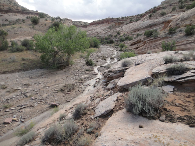
A sunny morning on the San Rafael River. Looking down canyon at the amazing geology of the region.
Fun With Weather
When I started walking on Monday my first river crossing, about one kilometer up river from the bridge, barely got the soles of my boots wet. I just hopped across the calm, clear river on exposed rocks. A few hours later when I had to cross over again I could tell the water had risen and was definitely more silty- there had been some rainfall far off to the west. Still, it was an easy crossing, with the water barely over my boots. I should mention that as part of my plan I retrieved my pair of OTB combat boots from the bottom of my gear closet- see my Escalante River Trek blog posts or Gear Review pages for more on those. I knew I would have to make some river crossings, and wasn’t sure how wet I would be, so I played it safe with these lightweight, quick dry boots with good drainage.
Monday night brought a few drops of rain, but nothing substantial. Tuesday was a calm, clear morning, ominously cool and quiet. Mid-day Tuesday I was at the point where the trail to Fuller Bottom branches off from the river, with about 2 kilometers to go to Fuller Bottom. I left my pack here and made a dash for the put in, but I didn’t quite make it all the way. As I made my approach on the road to Fuller Bottom I could hear thunder off in a couple of directions, but still felt safe enough to continue. I’ll summarise the events that quickly occurred over the next 15 minutes: the sky grew dark, the thunder became louder, lightning started flashing all around me, icy rain began to fall, then chunks of ice, then balls of hail, the rain became sheets of wind-blown rain, and visibility dropped to about 100 meters. What fun! I couldn’t think of a better way to spend an afternoon.

A drainage, dry an hour before, with water already quickly dropping.
The same drainage one and a half hours later. All you have to do is wait the storms out- don’t panic and try to make crossings. This is what gets people killed.
By the time all this happened I had found myself a dry, north-facing ledge to hide under; the storms came mainly from the south-southwest. Even though I was dry and safe, and I knew my pack was double-waterproofed (I use Sea to Summit ultralight silcloth pack liners), I was still a bit worried about it back there alone, tucked up under a juniper. My concern was not so much my pack itself, but being able to get back to it. My walk to this point had been up, down and through quite a few drainages that I knew were at this point filling up with water. I waited till the biblical squall had subsided and began making my way back towards my pack, curious to see what the drainages looked like. Sure enough, some of them had become raging torrents as the mesa tops were drained of the rain that had just fallen. Even the road I had just walked in on, dry 45 minutes before, was near waist-deep in water. What a storm. If you ever have the chance to safely view the outcome of storms like this, and see what flash floods are and can do, it is something not to be passed up. But again, do it safely. These storms can sweep you away in an instant, just as they do boulders, trees, and tons of other debris.

River flow graph for late July, 2014. From 2 to 1000 CFS in the course of 24 hours.
I’ll skip over the details of the walk back, but I made a few crossings that may have been safer with that PFD. My pack was where I left it. I retrieved it and started my return trip down the river. I had a plan to make it to a certain side canyon that evening, camp there, and explore it the next day. But that didn’t happen. A couple of hours later, another storm came, bigger than the previous, that kept me in place for the night. This was the storm that brought the river up to 1000 CFS from the 2 CFS that I started out with. There were no more river crossings to be done that day. The amount of water that fell from the sky, and then came raging down the river was astounding. The massive cascades of red water that fell from the previously dry and quiet canyon rims were deafening. The intensity of a storm like that really puts the power of nature into perspective. If you try to fight it, you don’t stand a chance.
The safe way to face a storm and flash floods like this is to simply find a high, dry if possible, place to spend some time. I was prepared to sit out the night under some cottonwoods; they offered some protection. But the storm passed, the sun came back out right at sunset, and the sky was clear overnight. The next day I continued down canyon, taking in the sights along the way, and wading a river that was again knee to waist deep.
So much for the weather details. The hike was a good one, but needed more time for the side canyons. Five or six days wouldn’t be too many. The access to the trailhead is an easy one, down a very well maintained. There is plenty of water on this hike (no need to carry too much on your back.) The “trail” is descent, though not technically maintained in any way- just by hikers, cows, and people on horses. There are lots of side canyons to explore, you might see some rock art along the way, and you will definitely see wildlife- bighorn sheep, peregrine falcons, wild turkey, a very large gopher snake, and deer were on my viewing list.

Curious bighorn sheep on the San Rafael River.
A few notes about walking rivers, something I have done a few times now. Plan to get wet. Waterproof everything. Use waterproof cases for your maps and camera. Make sure everything is secure before making crossings, especially if swimming. Remember to unbuckle waist and chest straps and remove one shoulder strap before water crossings- if you need to ditch your pack you don’t want to mess with buckles under water. Find good shoes or boots that will allow you to be wet, and somewhat comfortable.
A Visit to Green River
The San Rafael Swell is reached from the south through the town of Green River. Be sure to visit the town on your trip. Stop in for Mexican food either at the restaurant La Veracruzana, or the taco truck located next to the park in the old Shell station- good tacos and tamales can be found there. Green River Coffee is just down the street from either of these eateries, and if you are early enough they should be open. If you need water you can fill up at the back of the parking lot at the John Wesley Powell River History Museum right next to the river. If their water is not on, the West Winds truck stop has spigots at the gas pumps. Starting in the late summer, you won’t want to miss the melons available all through town. I loaded up on them before returning to Colorado. If you are around in September you can enjoy the town’s Melon Festival.
For more on our desert adventures, visit the Desert Explorer website. Next up: back to the San Juan River in mid-August.


 Posted by desertexplorer


