May and June in Southeast Utah- Nancy Patterson, Amtrak, and Grand Gulch

25 July 2016

We usually make a trip to southern Utah each year later in June, staying into July. This year we planned it so that trip was moved up to late May and into June. It made for more bearable and longer days at Nancy Patterson Village, and easier walking in the canyons later on. Of course there has been another trip since then where we enjoyed temperatures in the high 90’s and low 100’s.  We’ve had such a full summer so far there just hasn’t been time to get to a blog post until now.

Nancy Patterson Village
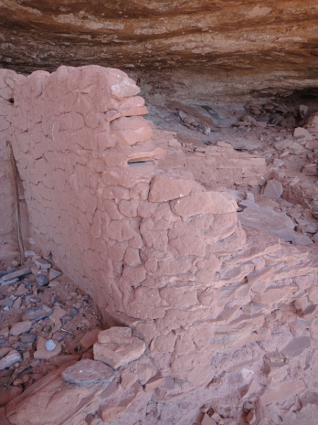
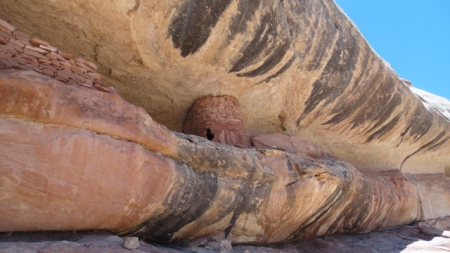
For the third season we spent a couple of weeks at Nancy Patterson Village doing archaeology. We finished the interior excavation of the room where we began in 2014. We have so much data at this point that it may take us into next summer just analysing and writing it all up. It was our assumption that our unit, being on the edge of the village, was late in date. We confirmed this, and we also confirmed our speculation that the room was built over an earlier midden. Our unit was in the eastern-most room of what I would call a patio group. The approximate size of the group is 13  by 13 meters. It is U-shaped, being open on the east side.

Collared lizards at Nancy Patterson Village. Photo by Gerald Trainor.

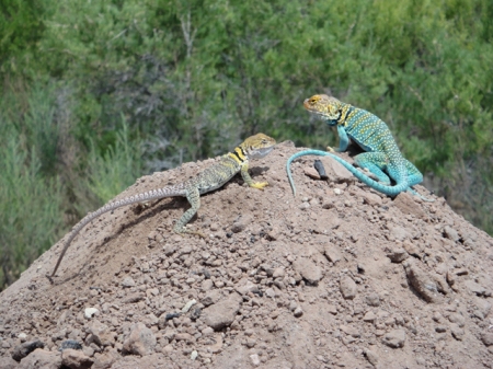
Working at Nancy Patterson Village would not be complete without our daily visits from collared lizards. Here a pair watches us from our backdirt pile.

Data collected from throughout the patio group indicate the earliest occupation is centered on the western side, or bottom of the “U”. The latest occupation appears to be our unit, the end room on the northern leg of the “U”. It is likely that the end room opposite us, to the south, is coeval with ours. There are other rooms and room blocks beyond our patio group out in the periphery; isolated rooms, those laid out in a linear fashion, and possibly an L-shaped group. These rooms are all unexcavated and the dates are unknown, but we assume they are closer to the date of our unit which was likely abandoned toward the “very end”, somewhere around the early to mid-1200’s. More about Nancy Patterson will be posted as we continue analysis and writing.

The young archaeologist at work. Nancy Patterson Village, Mesa Verde corrugated sherd being removed. Photo by Gerald Trainor.

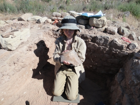
The young archaeologist at work at Nancy Patterson Village with a large Mesa Verde corrugated sherd from a post-abandonment artifact concentration just removed.


Amtrak as Part of Our Adventures
After our time at Nancy Patterson Village we had a few relaxing days at a couple of our favorite camps before Nicolai headed home. For those unfamiliar with the area around Interstate 70 north of Moab, a rail line roughly parallels the highway from Glenwood Canyon in Colorado to just past Green River in Utah, where it turns north toward Salt Lake City. The line is used by freight trains and by Amtrak as well. Since we hadn’t been on the train in a number of years, we decided to use it to get Nicolai back to Colorado. We boarded in Green River at about 8 AM and arrived in Glenwood Springs about noon where we met the missing member of our party (mom gets to hold down the fort when we are off in the bush.) The train ride, if there are no long delays, is scenic and enjoyable. You get to see a lot of country along this four hour stretch, and it’s best seen from the observation car. Unfortunately the trip back to Green River was not as quick nor as enjoyable. Just outside Glenwood Springs the train hit a truck which delayed us for about 4 hours. Believe it or not, the driver of the truck crawled out and walked away. The conductors on the train called it miraculous, and likened the train hitting a truck to a semi truck running over an empty soda can. The lesson- be careful at all railroad crossings, especially those without arms that come down to block traffic.

Amtrak train at Green River station, Utah. Photo by Gerald Trainor.

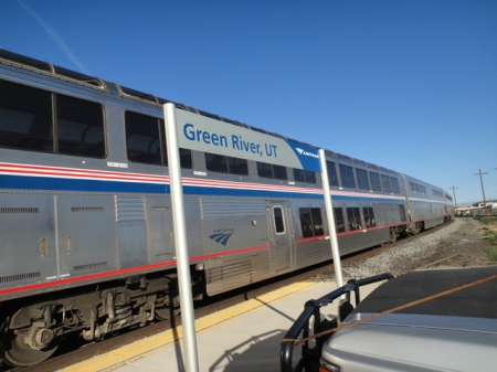
Ready to board, green River station platform.

Grand Gulch
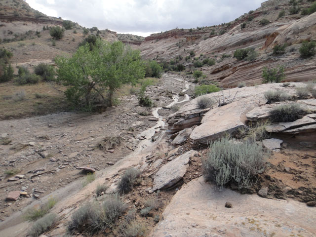
With Nicolai safely back in Colorado I had the next week or so to myself. So it was off to Grand Gulch for some alone time. I hadn’t been in Pine Canyon in some time, so I used it as my entrance. I parked at the drill hole at the end of the road and was in the canyon in no time. It’s a fairly easy walk all around- across the mesa, the climb in, and the walk down to Grand Gulch. I found the canyon very different from the previous trip about 7 weeks before. During our April backpack the canyon bottom was filled with water; we were faced with skirting around pools and hopping across water running down Grand Gulch. This trip, water was barely visible in the bottom of Grand Gulch. There were a few green, debris covered pools here and there that were of course drinkable, but it was like night and day compared with two months before. The weather was warming at this point, and the heat and lack of water ensured that I was the only one in the canyon- I didn’t hear or see anyone on this trip.

Ruin in Pine Canyon, southern utah. Photo by Gerald Trainor.

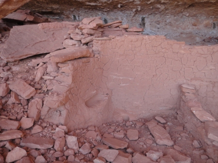
Round ruin in Pine Canyon with very interesting architectural change in structure- due to available materials or aesthetics? Note vertical slabs down low, with regular, coursed masonry above.

I could go on as always, but will save it for another post. Next up- more on our new inReach SE, rock art in a boulder field, and parallel stone alignments leading the way to Spirit Bird Cave. For more on our desert adventures, gear reviews, and our archaeological endeavors, visit the Desert Explorer website.


Another Spring Break in Canyon Country

21 April 2016

We have just returned from southern Utah once again. It was a late spring break for us, but well worth waiting for April to make the trip. The weather was perfect right up till the end, when we caught a bit of the storm that brought winter back to Colorado. We spent our two weeks in the usual places, revisited some of our favorite canyons, and explored some new ones. We made it a point to include plenty of time enjoying sunrises, sunsets, and the star filled night sky, and more than a few afternoons sitting on the slickrock with a cup of tea.

Blooming holly. Photo by Gerald Trainor.

Holly in bloom. The desert was alive with color and fragrance.

Our itinerary brought us straight to southern San Juan county this time. We made an afternoon stop in Moab for final supplies as always, but the weather was so perfect that Moab was too busy for us. April is the perfect time of year for most people- warm days and not too cool nights, without the extreme heat that comes in another month or so. Besides ATV’s and other off-road vehicles, there were mountain bikes everywhere, and more RV’s and camp trailers to be found around every corner than I have ever seen. This was the case everywhere we went- down every road whether it be along Comb Ridge, on Cedar Mesa, or around Green River, where we finished up our trip.

Grand Gulch
We did get a few days of backpacking in this trip. We walked in through Dripping Canyon, had a day in Grand Gulch, and walked out Step Canyon. This is something I have done before, so knew the walk quite well. It was perfect for Nicolai and I- nothing an 11-year-old couldn’t handle. As always, we could have used a couple more days in this short stretch of the canyons- there was just so much to see that we had to choose where to spend our time. For anyone venturing in any time soon, water was not a problem. At least finding drinking water that is. From another perspective, that of walking, it was quite a problem in places. There was so much water in the canyons that we found ourselves skirting pools all along the walk, and especially in Grand Gulch.

Yellow ancestral puebloan pictograph in Grand Gulch, Utah. Photo by Gerald Trainor.

“Yellow Man” panel in Grand Gulch.

Cedar Mesa was a busy place. The Kane Gulch ranger station was packed on the few occasions we stopped in. But once we got in the canyons we only saw, and heard, one group of people. I should say heard more than saw them. Their presence was known to us by their extremely loud voices, yelling I would call it, and their crashing wildly through the brush. We made it a point to discuss this problem with the folks at the ranger station after our walk- noise pollution is  a problem everywhere and especially in such a place as this. I feel that these days so many people don’t know the difference between a place that is… sacred, and say, the grocery store. The analogy I like to use is that I would not come bounding and crashing and yelling into your church, so please don’t come into mine that way. But I suppose, to continue the analogy, I am preaching to the choir here.

Comb Ridge
We have a favorite camp in view of Comb Ridge making it easy to get into the canyons there. We spent five nights on the slickrock at that camp, really enjoying the night sky. I have to make a plug here for one of my more recent equipment purchases. I have been sleeping better than ever these days on an Exped SynMat 7 Sleeping Pad. This inflatable sleeping pad has an integral pump which inflates it in just a couple of minutes. No blowing it up by mouth involved! I have the synthetic fill version which is rated at an insulation value of 4.9, but there is a higher rated pad that has down filling.  I use it at the truck and on the river- it’s just too heavy for me to carry on a backpack. The pads are not cheap, but if you are struggling with getting a good night’s sleep on a thinner pad, you may want to give one a try.

We spent a couple of days exploring Comb Ridge, and as always found more ruins and rock art, middens and moki steps, sweat lodges and seasonal campsites. Comb Ridge is truly a place where one can learn about the varied archaeology of the Northern San Juan region all in one place. One ruin we visited stood out in the amount of mud that was plastered on the walls. The ruin lacked for stone, but still held together well with mud. Looking at it you could see the way it was applied, in great masses, each appearing to be left to sag and dry before the next mass was applied. The interior of the walls had niches built-in, and the end walls were curiously rounded, as if they were not continued across the front, but were left open.

Ancestral Puebloan structure in Comb Ridge, Utah. Photo by Gerald Trainor

Comb Ridge ruin with walls lacking in stone but showing an abundance of mud.

Ancestral Puebloan dwelling in Comb Ridge, Utah. Photo by Gerald Trainor.

End wall of plastered ruin showing rounded finish. Note the thick mortar beds between the thin pieces of sandstone.

There is always so much to see, and to write about afterwards, on our Utah trips. But for now it’s back to preparation for the next trip. In about a month we are back in southern Utah for more archaeology at Nancy Patterson Village. For more about us and our desert adventures visit the Desert Explorer website.


Trip Report- July, 2014- San Rafael River Backpack

7 August 2014

I had a chance to spend a few days on the San Rafael River at the end of July. I went in on Monday and returned Wednesday evening. I was alone, so it was an out and back hike to Fuller Bottom, starting and ending at the San Rafael River bridge, about 15 miles each way. I looked up a few side canyons although conditions and time didn’t allow for much exploration. I will definitely need to go back. The walking was easy, the “trails” fairly clear and not too brushy, and it wasn’t terribly hot even though the forecast was calling for temps over 100 degrees.

I traveled light as usual foregoing even a sleeping bag this trip, taking a Golite nest for bugs and an Integral Designs Ultralight Bivy Sack and silcloth poncho. All in all these were good choices. Of course I had the usual backup lightweight ploypro top and pants, Golite Trinity raingear, and a couple of other items for safety. The only piece of gear I didn’t have and could have used was a PFD  (Personal Flotation Device), but more on that later.

San Rafael river canyon. Photo by Gerald Trainor.

A sunny morning on the San Rafael River. Looking down canyon at the amazing geology of the region.

Fun With Weather
When I started walking on Monday my first river crossing, about one kilometer up river from the bridge, barely got the soles of my boots wet. I just hopped across the calm, clear river on exposed rocks. A few hours later when I had to cross over again I could tell the water had risen and was definitely more silty- there had been some rainfall far off to the west. Still, it was an easy crossing, with the water barely over my boots. I should mention that as part of my plan I retrieved my pair of OTB combat boots from the bottom of my gear closet- see my Escalante River Trek blog posts or Gear Review pages for more on those. I knew I would have to make some river crossings, and wasn’t sure how wet I would be, so I played it safe with these lightweight, quick dry boots with good drainage.

Monday night brought a few drops of rain, but nothing substantial. Tuesday was a calm, clear morning, ominously cool and quiet. Mid-day Tuesday I was at the point where the trail to Fuller Bottom branches off from the river, with about 2 kilometers to go to Fuller Bottom. I left my pack here and made a dash for the put in, but I didn’t quite make it all the way. As I made my approach on the road to Fuller Bottom I could hear thunder off in a couple of directions, but still felt safe enough to continue. I’ll summarise the events that quickly occurred over the next 15 minutes: the sky grew dark, the thunder became louder, lightning started flashing all around me, icy rain began to fall, then chunks of ice, then balls of hail, the rain became sheets of wind-blown rain, and visibility dropped to about 100 meters. What fun! I couldn’t think of a better way to spend an afternoon.

Flash flood in San Rafael River. Photo by Gerald Trainor.

A drainage, dry an hour before, with water already quickly dropping.

Flash flood along San Rafael River. Photo by Gerald Trainor.

The same drainage one and a half hours later. All you have to do is wait the storms out- don’t panic and try to make crossings. This is what gets people killed.

By the time all this happened I had found myself a dry, north-facing ledge to hide under; the storms came mainly from the south-southwest. Even though I was dry and safe, and I knew my pack was double-waterproofed (I use Sea to Summit ultralight silcloth pack liners), I was still a bit worried about it back there alone, tucked up under a juniper. My concern was not so much my pack itself, but being able to get back to it. My walk to this point had been up, down and through quite a few drainages that I knew were at this point filling up with water. I waited till the biblical squall had subsided and began making my way back towards my pack, curious to see what the drainages looked like. Sure enough, some of them had become raging torrents as the mesa tops were drained of the rain that had just fallen. Even the road I had just walked in on, dry 45 minutes before, was near waist-deep in water. What a storm. If you ever have the chance to safely view the outcome of storms like this, and see what flash floods are and can do, it is something not to be passed up. But again, do it safely. These storms can sweep you away in an instant, just as they do boulders, trees, and tons of other debris.

River flow graph for late July, 2014. From 2 to 100 CFS.

River flow graph for late July, 2014. From 2 to 1000 CFS in the course of 24 hours.

I’ll skip over the details of the walk back, but I made a few crossings that may have been safer with that PFD. My pack was where I left it. I retrieved it and started my return trip down the river. I had a plan to make it to a certain side canyon that evening, camp there, and explore it the next day. But that didn’t happen. A couple of hours later, another storm came, bigger than the previous, that kept me in place for the night. This was the storm that brought the river up to 1000 CFS from the 2 CFS that I started out with. There were no more river crossings to be done that day. The amount of water that fell from the sky, and then came raging down the river was astounding. The massive cascades of red water that fell from the previously dry and quiet canyon rims were deafening. The intensity of a storm like that really puts the power of nature into perspective. If you try to fight it, you don’t stand a chance.

The safe way to face a storm and flash floods like this is to simply find a high, dry if possible, place to spend some time. I was prepared to sit out the night under some cottonwoods; they offered some protection. But the storm passed, the sun came back out right at sunset, and the sky was clear overnight. The next day I continued down canyon, taking in the sights along the way, and wading a river that was again knee to waist deep.

So much for the weather details. The hike was a good one, but needed more time for the side canyons. Five or six days wouldn’t be too many. The access to the trailhead is an easy one, down a very well maintained. There is plenty of water on this hike (no need to carry too much on your back.) The “trail” is descent, though not technically maintained in any way- just by hikers, cows, and people on horses. There are lots of side canyons to explore, you might see some rock art along the way, and you will definitely see wildlife- bighorn sheep, peregrine falcons, wild turkey, a very large gopher snake, and deer were on my viewing list.

Bighorn sheep on the San Rafael River. Photo by Gerald Trainor.

Curious bighorn sheep on the San Rafael River.

A few notes about walking rivers, something I have done a few times now. Plan to get wet. Waterproof everything. Use waterproof cases for your maps and camera. Make sure everything is secure before making crossings, especially if swimming. Remember to unbuckle waist and chest straps and remove one shoulder strap before water crossings- if you need to ditch your pack you don’t want to mess with buckles under water. Find good shoes or boots that will allow you to be wet, and somewhat comfortable.

A Visit to Green River
The San Rafael Swell is reached from the south through the town of Green River. Be sure to visit the town on your trip. Stop in for Mexican food either at the restaurant La Veracruzana, or the taco truck located next to the park in the old Shell station- good tacos and tamales can be found there. Green River Coffee is just down the street from either of these eateries, and if you are early enough they should be open. If you need water you can fill up at the back of the parking lot at the John Wesley Powell River History Museum right next to the river.  If their water is not on, the West Winds truck stop has spigots at the gas pumps. Starting in the late summer, you won’t want to miss the melons available all through town. I loaded up on them before returning to Colorado. If you are around in September you can enjoy the town’s Melon Festival.

For more on our desert adventures, visit the Desert Explorer website. Next up: back to the San Juan River in mid-August.


Spring Break Trip Report- March 2014

6 April 2014

We have just returned from one if the most memorable Spring break trips in years. The trip included some of our usual endeavors- seeing rock art and ruins, a bit of gold panning, hiking along Comb Ridge, and plenty of exploring of dirt roads around southeastern Utah. It also included new adventures: a visit to Oljeto, on the Navajo reservation, to see the trading post where the Wetherills lived and then a drive down to the now defunct Piute Farms Marina at what was once part of Lake Powell.

Piute Farms waterfall. Photo by Gerald Trainor.

Piute Farms waterfall, about two miles below Clay Hills takeout, March 2014. The river below actually looked like a river. There were few signs that the lake had made it this far up the channel in years.

We also stopped in at Hite “Marina” (can you have a marina without water?) to take a look at the lake level on our way towards Hanksville. We drove down the boat ramp only to find that we could keep driving all the way across what used to be the lake right to the edge of the Colorado River. And it did look like a river- cutting down through the accumulated silt of the past 50 years and making its way toward the ocean. Looking down river, there was no lake in sight! Looking up river, the Dirty Devil was a muddy little stream braiding its way through the silt and into the Colorado. I can’t help but wonder how long it will take to clean out all that silt…. But more on that in a future blog.

Colorado River at Hite Marina. Photo by Gerald Trainor.

The Colorado River, at Hite Marina. Looking down river, as it makes its way to the ocean.

Silt plain that was once Lake Powell. Photo by Gerald Trainor.

I hope this adds a bit of perspective to what is going on at Hite Marina. This photo was taken at the edge of the river, where I stood when I took the top photo, looking back over the silty, tumbleweed-scattered plain that was once the bottom of Lake Powell. That is our Landcruiser in the middle distance, with the boat ramp far off in the photo.

Back to the archaeology for now. One of our early stops was just outside Blanding to look at a few rock art panels and nearby ruins. We met up with a group of archaeology students, their “tour” leader Daniel Cutrone, the Principle Investigator at the Nancy Patterson site in Montezuma Canyon and professor at California State University Dominguez Hills, and our friend Madalyn from the Edge of Cedars Museum in Blanding.

Nancy Patteson site. Photo by Gerald Trainor.

A central view of the Nancy Patterson site, showing excavated walls and many of the mounds that make up the possible 300 rooms of the site.

Daniel, Madalyn, and their crew kindly took us along on their outings to a few unnamed sites, the Nancy Patterson site, Spirit Bird Cave, and a behind-the-scenes tour of the Edge of Cedars Museum. We were joined on one of the days by Sally Cole, author of Legacy on Stone, among other titles. What a treat it was to look at rock art and not have to pull out our copy of her book for interpretation- all we had to do was listen! The best part for both Nicolai and I was when we were asked if we wanted to return in the summer to be part of the ongoing excavation of the Nancy Patterson site. I haven’t done any excavation in years, and definitely welcome the return to the dirt. For Nicolai, I think it is a dream come true. For more on the Nancy Patterson site, ongoing excavation, and field work possibilities, see the Shovelbums Website.

We spent a few days in Poison Spring canyon, as we often do, enjoying the sites there and some of the slot canyons accessible from the canyon bottom. Next we drove on to Green River town. In and around Green River we explored the abandoned U.S. Army Pershing missile launch complex. What an adventure that was!

Green River missile launch complex. Photo by Gerald Trainor.

The guard shack and associated buildings at one of the main parts of the Green River launch complex.

Abandoned around 1979, the buildings are in a serious state of decay, with doors falling off or missing, fences broken down from power poles falling on them- the power poles having been chopped down by looters stealing the copper wire strung between them! Ceilings had fallen in, windows were mostly broken out, and nearly everything that could be carried away had been. And the few things left on site were well smashed up and thrown into piles in corners. It was perfectly post-apocalyptic in look and feel, including a grey, overcast sky above us. While exploring I kept expecting to round a corner to find a growling pack of ferrell dogs, or maybe zombies, or at least a boy and his father resting as they made their way down The Road. Perhaps that was us?

Tent city concrete pads. Photo by Gerald Trainor.

The concrete pads, perfectly aligned and dressed right, at what is referred to as the “tent city” outside Green River.

Bunker near Green River, Utah. Photo by Gerald Trainor.

Nicolai next to the bunker at the weather missile launch pads.

Either way, let it be known that we never crossed a fence, or a building threshold, as it is still government property and clearly marked as of limits… in a couple of places at least (most of those signs appear to have been stolen.) If you go, be sure to view it from afar.  We spoke to a local deputy who warned us that theft and vandalism have ramped up recently and that they are watching the sites. I have only touched on this marvel of modern science, warfare, our military-industrial complex, and our cold war history. Volumes could be written about it- not by me however. But I do plan to write a full blog about the site, and the Pershing and weather monitoring missiles launched from it in the near future.

Missile launch pad near Green River, Utah. Photo by Gerald Trainor.

One of the main launch pads, with rolling building still in place. There are two other, identical pads, both without the building or even the rails that it rolls on.

For now, we are planning our summer fieldwork, a family backpacking and exploring trip, and a solo trip for me. The summer promises to be a full one- be sure to get out and enjoy it. And watch out for rattlesnakes, they are already out. For more about snakes, and our desert adventures, visit the Desert Explorer website.


Trip Report- Green River Family Float- August 2012

13 September 2012

This year we made our way back to the Green River for our family float. We put in on the 19th and took out on the 26th of August. The weather was perfect- not too hot, cloud cover in the afternoons,  and only a couple of storms- one big, dramatic one that put our aging Sierra Designs tent to the test. It held up for the most part, but the zipper has finally given out after 20 plus years of use. A point of note for other Sierra Designs users- I called to see about a zipper replacement and was given an online code for 45% off any new tent. The zipper replacement could reach as much as $125, and while not quite reaching the cost of the new tent, it was close enough. So next year we’ll be trying out the Sierra Designs Zolo 3. Look for  a review of that at some point.

beach camp on the Green River. photo by Gerald trainor.

One of our perfect beach camps. We found them around every bend in the river this year.

Back to the river- as usual, there were no bugs, and because it was a little later in the season, we saw on average one other group each day. All in all it was a very calm and quiet float. Unfortunately we missed the fast water last year, when we floated the San Juan. So this time we rowed, and rowed some more. The water averaged about 1200 CFS and we planned accordingly. We gave ourselves 8 days to get from town down to Mineral Bottom, so that we wouldn’t be rushing and could enjoy the big sandy beaches all along the 64 miles of our float. In the end, as usual, we could have used 10 days, or maybe 14, or a whole month if it could be managed- the truth is that the surprises that nature provides are never-ending and a person could spend a lifetime out there enjoying them.

Nicolai Trainor at Crystal Geyser, Green River, Utah. Photo by Gerald Trainor.

Nicolai enjoying the shade of our beach umbrella, on the beach at Crystal Geyser.

After dropping our permit at the J.W.Powell River History Museum, we put in at the bridge in Green River as usual. The permit for this section of river is free and you can download the PDF from the BLM website. Fill out a copy for the BLM and drop it at one of the locations noted, and take one on the river with you. If you plan to float on into Canyonlands National Park, there is a charge and the logistics get more complex.  See the Floating the Lower Green River page at the Desert Explorer website for more information. 

We parked the tuck “downtown” this year. In the past we parked at the museum, but they no longer allow parking there. Ask at the museum or around town for recommendations on where to park. Before heading down river, we loaded up with melons. If you float the Green River in the fall you are obligated to carry as many melons as you can to enjoy along the way. This trip was the first for our new boat, a Cutthroat 2 cataraft from Jack’s Plastic Welding so there was plenty of melon-cargo space. This section of the Green River down into Labyrinth Canyon, and on through Stillwater Canyon, especially at this time of year, is a flatwater float. Canoes are faster, sea kayaks are fastest-we saw a couple of them out there. But the “big” boat made it so we had plenty of gear and provisions and amenities.

Cutthroat 2 in front of the Inkwell on the Green River. Photo by Gerald Trainor.

The new boat, fully loaded, in front of the Inkwell.

After making it under all the bridges and through the riffles, we made our first stop at Crystal Geyser only to find that the ground was dry. It did not appear that the Geyser had erupted in some time, certainly not as we had seen it in past years. It has been a dry year, with low water, and the lack of eruptions could be reflecting the lack of ground water recharge this summer. From there on we made some of the usual stops,taking alook in Three Canyon, hiking up to the saddle at Bowknot Bend, up canyon to one of the Julien inscriptions, and taking a look at the other inscriptions- historic and prehistoric- along the way.

View from Bowknot Ridge, Green River. Photo by Gerald Trainor.

The view from the top of Bowknot Ridge- up river is to the right, downriver to the left. The view is well worth the short hike up.

All of our camps were on big, clean sandbars. They were found around practically every corner this year, one benefit of low water. This gave us plenty of room for the sunshade, a big camp, and frisbee. We didn’t have any fires this year- there was a fire ban in place. You can check current fire conditions at the Utah Fire website.

We took out at Mineral Bottom and were met by Moab Taxi for a shuttle back to Green River to retrieve the truck. Mineral Bottom road was fine for the most part, although there were a couple of questionable spots on the switchbacks due to a recent storm. High clearance at least was necessary; four wheel drive was just more insurance of safety. After taking out, we spent a couple of days in Moab and enjoyed the new pool, Wicked Brew coffee, and a delicious breakfast at Eklecticafe. The cafe is right on Main Street near Posion Spider Bicycles and is only open for breakfast and lunch.

For more on our floats and other desert adventures visit the Desert Explorer website.


Spiders and Beetles, Dalton Wells, Great Horned Owls, and Escalante Photos

8 August 2011

The summer is a busy time for us- busy and fun- and this summer has been one of the busiest in recent years. We have been travelling since March, barely home at all. We’ve seen and done so much that it is hard to keep up with it. This will be a quick post- a follow-up on a couple of earlier posts, and few words about our most recent trip. And as soon as I finish this one, we are off again- we have a permit for the San Juan River next week. Look for a post from that trip in a few weeks time.

Spiders and Tamarisk Beetles
As luck would have it, Nicolai and I found ourselves with some free time a couple of weeks back, and we weren’t too far from Green River Town. We stopped in town for a cup of coffee and some ice for the cooler. Then we made a visit to Crystal Geyser where we had a swim in the still-swift Green River and spent a couple of hours waiting for the geyser to blow. The geyser wasn’t too active, but we did get to talk to a researcher from Grand County who was checking the condition of tamarisk trees and the resident beetle populations. He happened to be checking a group of trees that were covered with those big spiders that we have encountered on our floats down the Green, so we asked for more information about them. He couldn’t tell us specifically about the spiders, but he did say that they seem to be following the beetle populations. It seems that they are feeding on the beetle larvae. He said that in that area in particular he had noted a couple of groves that were covered with the spiders. It seems that the beetles do have a natural, local enemy, a question I am sure that researchers asked when they were deciding whether to allow the beetles to be released.

Unidentified species of spider at our camp at Crystal Geyser. This photo was taken on our float of the Green River in 2009.

Moab and Dalton Wells
On that same trip we made a visit to Moab, as we usually do. This time we did some driving around on roads and trails in the Sovereign area  north of town. One of the entrances to the Sovereign trail is through Dalton Wells, a historic site located just off the highway. It is on the National Register and there is an interpretive plaque explaining the history of the site. Dalton Wells began as a Civilian Conservation Corps camp and was in use for that purpose from 1935 to 1942. It was one of four camps located in the Moab area. The CCC members were responsible for countless projects in the Moab Valley and surrounding area during the years the camp was in operation. These projects were initiated by the Soil Conservation Service, the National Park Service, and what would become the Bureau of Land Management and included building stock trails, water development projects, range improvements, and fencing and pasture work.

From January through April of 1943 the Dalton Wells CCC camp became the “Moab Isolation Center”, one of many relocation camps for Japanese Americans during World War II. The camp was used for this purpose only briefly, and housed “troublemakers” from such camps as Manzanar in California and Gila River, Arizona. At most it housed about 4 dozen men, who were eventually transferred to the indian school at Leupp, Arizona on 27 April, 1943.

There are a couple of websites with more information on the camp- one is the Utah State History website, the other is the National Park Service page on Citizen Relocation Centers. The latter page has a couple of photos of the camp.

Great Horned Owls
In April we made a visit to Phoenix and Tucson where we visited the Arizona-Sonora Desert Museum among other locations. There is  a blog post about that trip for those interested in reading more. In Tucson we stayed in a hotel in the foothills that was also home to a Great Horned Owl and her two young ones. The owlets lived in a large planter box surrounding the deck of a second floor room of the hotel. It appeared that the hotel was respecting the owls by keeping the associated corner room vacant. Our room was right next door to the vacant room and so we had a great view of the owls, day and night. During the day the mother would sleep in a nearby pine tree, up high near the very top. The owlets would huddle together in the corner of the box, as far from onlookers as they could get. At one point the mother brought in a cottontail for the owlets to eat. They moved the rabbit around a bit, and we got to watch one of the owlets have its morning meal. At nights the mother and young ones would perch on the edge of the planter box, keeping a close eye on everything through the night. The mother would fly off and return all through the night, and would leave early in the morning for her daytime rest in the pine tree.

Mother and owlet Great Horned owls at their hotel room in Tucson. Photo by Gerald Trainor.

Mother and owlet Great Horned owls at their hotel room in Tucson. The owlet to the right that is bent over was only concerned with its rabbit breakfast. Most of the rabbit is in the foreground near the cactus.

Owlets in the planter box, Tucson. Photo by Gerald Trainor.

Owlets in the planter box.


Owlets huddling together for their daily rest in the early morning. Photo by Gerald Trainor.

Owlets getting ready for their daily rest in the early morning.

Final Words on Escalante Trip

I have covered nearly everything I wanted to regarding my Escalante Trek in recent blog posts. The only loose end was posting photos of the trip. I have finally done that. A series of photos from the trek is up on the Desert Explorer Picasa page. For more on our desert adventures, desert backpacking, floating and general information, visit the Desert Explorer website.

Mineral Bottom Road Open, White Rim Trail Closed (again), Green River Reaching Record Flows

12 June 2011

I have had a few inquiries and comments lately about floating the Green River. An update on conditions is on order.

As of 29 march, 2011 Mineral Bottom Road down to the Mineral Bottom boat ramp is open. The switchbacks that were washed out last August have been repaired- and the road looks nice! You can read more and see a photo at the NPS website. But, I was told by someone in Moab a few weeks back that the road from the bottom of the switchbacks up to the boat ramp is now under water. Here is a quote directly from the NPS website: “The road to the Mineral Bottom ramp may be flooded at flows above 30,000 CFS. If this occurs, vehicles left at the Mineral Bottom parking lot will be stranded until the water recedes.” Flows today at Green River town according to the USGS water data website were at about 45,600 CFS- close to reaching record levels.

The White Rim Road was open briefly, but is now closed again. Rain and hail closed the Schafer Trail on the east side of the park on the 18 May. And now the extremely high flows on the Green River have flooded the low sections of the White Rim Road right along the river. According to the 19 May 2011 issue of the Moab Times-Independent, flooding along these sections occurs when the flows reach about 20,000 CFS. You can read more about closures at the NPS website.

Be sure to check in with the the appropriate agency before you leave home if you are planning a trip any time soon. You may have to change your plans. If you are floating any time soon- have fun and be careful.

You can read more about our Green River adventures, and enjoying the Utah desert at the Desert Explorer website.


A Quick Post From Moab

23 May 2011

I am in Moab today, heading in the direction of home. I’ve spent nearly the last two weeks in the Escalante, down Moody Canyon to the Escalante River and points south and west of there. The backpack, although windy, cold, and rainy at times, was a complete success. I ended up walking a comfortable 100 miles in 8 days time. I will outline the details in a series of posts once I get back home in a few days. There is a lot to cover and it will take two or three posts to do it. Besides discussing the walk itself, I plan to review a few new pieces of equipment including the Golite Trinity Malpais jacket, OTB Desert Boots, and Rokit Fuel endurance foods that I tried out, and discuss some issues I had in the area once again (involving Leave No Trace policies).

A few quick points of note from Moab this afternoon:

  • On the way through Hanksville yesterday the Dirty Devil River from the bridge looked about as high as I have seen it. Lots of water flowing in Southern Utah right now. I am thinking about getting home as fast as I can and arranging a float trip right away.
  • While driving through Green River this morning I saw that the Green is very high as well, extremely high in fact. There are sand bags piled at the river’s edge at the hotel across from the J.W. Powell River History Museum. I drove down to Crystal Geyser and the water there is up to the geyser’s lower ledges of mineral deposits. Time to float the Green if you can get away to do it!
  • Here in Moab the new recreation center is open. I stopped in this morning and had a look. If it weren’t overcast, rainy, and breezy I would consider going for a swim. The place is truly a gem. Stop in and take a look next time you are in town.
  • Finally, Horsethief Road down to Mineral Bottom is open. Apparently it has been open since late March. Talk is that the drive down is much nicer than it used to be. Now the bad news- the river is currently so high that you might not be able to drive over to Mineral Bottom. I am told the water is up to and covering the road in places. Be sure to check in with the Park Service before finalising any upcoming trips.

That is it from Moab this afternoon. I am off to look at some rock art now. Check back in the next week or so for the first of my post-Escalante Trek posts.

Until then visit the Desert Explorer website for more information on the region.


Back From the Bush, Planning the Next Trip

31 March 2010

It is the time of year when I wish I could just stay over in Utah.  The winter is nearing its end and we are ready to get out. And two weeks is just never enough time, no matter the time of year. Nicolai and I had a great trip though, as always.  The weather cooperated for the most part.  There were a few cold nights, a few cold mornings, and of course the usual strong winds.  Precipitation was very limited- we had a couple of snow flurries that lasted all of an hour at the most, and a couple of light rains that passed in a few hours.

We started our trip as we usually do at our “secret” camp site overlooking the train tracks near Westwater.  From there we made a counter-clockwise loop to Moab, Green River, through the Green River Desert (along the edge of the Green River) to Horseshoe Canyon, Hanksville, down towards Hite, Cedar Mesa, and Mexican Hat, then up through Blanding and Moab back to I-70.

Horseshoe Canyon
We visited some new locations, including Horseshoe Canyon to look at rock art. The panels down there are just amazing, truly some of the best you will ever see.  And the preservation, for the most part, is great.  Nicolai was a bit confused about why there was a chain keeping us back from the rock art at the Great Gallery.  He understands that some people deface the rock art with their graffiti; he is quick to pick it out on nearly any panel.  When I explained that the idea is to protect the panels so that he can come back to see them in 50 years, he kind of felt okay about it.  We sat at the Great Gallery for a couple of hours, taking in the paintings, the clear sky, the trickle of water flowing down Barrier Creek.  We will undoubtedly return there.

The "Holy Ghost" panel, Great Gallery

"Shepherds dancing", great Gallery. Note the animated figures with staffs in the lower left.

Mexican Hat
On many of our journeys to southeast Utah we stop in at the San Juan Inn in Mexican Hat for breakfast. We have  a campsite at the southern end of Cedar Mesa that we frequently stay at, and that puts us only about 1/2 hour away from breakfast at the Olde Bridge Grille.  One of the people working in the dining room is Navajo artist Joey Allen.  We saw some of his prints last year and had hoped to buy one from him this time. Unfortunately he didn’t have any along, but they can be purchased from his website.

Hunting and Primitive Skills
Anyone who has read our blog or visited the Desert Explorer website knows that we focus a lot of our time on primitive skills.  On this trip we experimented with using rice grass for making the birdsnest for starting fires. We used it on many nights with the metal match, and gave it a try a couple of times with the spark from our bow and drill.  It required a bit more striking with the metal match to warm the material up than does Juniper bark for example.  I am sure this is because the material is more coarse.  The grass burst into flames with a couple of blows after dropping the spark from the bow and drill into the birdsnest.

Our fire kit with ricegrass birdsnest flaming.

In our last post we included a photo of a not-so-perfect obsidian knife we had made.  The inspiration for that knife is at the Edge of Cedars Museum in Blanding.  There are four beautiful knives on display there from a cache in nearby Westwater Canyon. They are normally displayed in the “visible storage” area upstairs.  But now they are downstairs in a plexiglass cube as part of a new exhibit, allowing me to get a decent photo of them.

Three of the four hafted knives on display at the Edge of Cedars Museum in Blanding.

Nicolai loves the knives and  we had to go back for a second visit to look at them, and take a few more photos for him, before we could leave Blanding.

We had originally planned to shoot a rabbit or two on this trip.  Nicolai had plans for the meat, as well as the pelts and other parts. But we did not have the best luck hunting during the time we had our license.  We did find tracks and scat, nothing fresh, but no rabbits made themselves visible to us. We did have some fun firing our Ruger 10/22 though.  It was Nicolai’s first time firing it and he loved it.  It seems it will be a permanent part of the packing list for Utah from now on. And we’ll try our luck at finding some rabbits next trip.

He's a pretty good shot, with a little help.

SPOT GPS Messenger
Finally, we did try out our new SPOT.  We sent at least one “okay” message from our camp each night. We sent out our custom message whenever we found rock art or ruins.  I made note of where and when each message was sent. Every message made it through, without fail.  You can click on the links that are sent out and view “road” maps, toppgraphic maps, or satellite maps. From our end on the ground, it took only seconds for the “message sent” light to start blinking.  I was a little skeptical about that, so took notes on each “send”.  I am more of a believer now.  It is a great way to keep in touch and let friends and family know you are on track and okay.  And should you need it, it might save your life. You can read more about the SPOT and how it compares to PLB’s in some of our past blog posts or at the Desert Explorer website.

Our SPOT GPS Messenger connecting with GPS satellites for location information before sending our custom "found rock art" message.

This  post has provided a quick summary of some of our trip. We will post more in-depth soon about the rock art we saw and other locations we visited that might be of interest  to everyone.


Family Float on the Green River, Green River town to Mineral Bottom

21 August 2009

We floated the Green River from Green River town to Mineral Bottom from 02 August through 07 August 2009.  We had a leisurely float, as the Green River seems to provide at this time of year.  Paddling was not optional, and, as usual, we could have used more time.  We can always use more time in Utah!  River flows were just under 3000 CFS, and the weather was rather cool, in the 80’s each day.  The usual crazy winds blew up river each afternoon, but died out in time for dinner.  The moon wasn’t  full till the day after we took out, but it was full enough that we enjoyed the nights on our sandbar camps without flashlights.

Rigging boats under the shade across from the JW Powell Museum.

Rigging boats under the shade across from the JW Powell Museum.

We put in above the bridge in Green River on Sunday afternoon.  It is an easy place to put in, with plenty of room and good shade under some big cottonwoods if you rig early enough in the day.  We left the Land Cruiser in the parking lot at the John Wesley Powell River History Museum.  The signs there say “No Overnight Parking”, but if you let them know your plans in the museum, leaving vehicle information and your float dates, your vehicle is okay there.  You can leave your permit with them as well- they are an authorised permit issuer for the river.

Long exposure of tent at night. We have a string of solar lights we use in the tent on the river which light it up well. Moon is near full, Jupiter is also visible.

Long exposure of tent at night. We have a string of solar lights we use in the tent on the river which light it up well. Moon is near full, Jupiter is also visible to the right of the moon.

The permit for this section of river is free and there is no lottery for it, just download the PDF from the BLM website, fill out a copy for the BLM and one to take on the river. If you plan to float on into Canyonlands National Park, there is a charge and the logistics get more complex.  See the Floating the Lower Green River page at the Desert Explorer website for more information.  You can also park, leave your permit, and put in at Green River State park, about half a mile down river.  It will cost five dollars to get in, and roughly about 20 dollars for a week of parking.

Make sure you allow enough time in your itinerary to visit the museum, at least an hour or so.  Do it before your float if you can, and the river will be all the more interesting as you float along and see the same scenery that the Major and his party experienced back in 1869.

There is only one market in Green River, the Melon Vine Food Store, near the west end of town.  They are closed on Sunday.  There are many gas station convenience stores for last minute drinks and ice.  Water can be found at a couple of the gas stations as well as in the picnic area at the River History Museum.  It used to be available a the park in the center of town, but there is only a drinking fountain there now.

Boats at the edge of the river at Crystal Geyser.

Boats at the edge of the river with mineral deposits from Crystal Geyser in the background.

During our float, we camped on sandbars most nights, but opted to camp at Crystal Geyser on our first night.  We fully expected company, and we had it.  Crystal Geyser is a popular place, easily accessible by about any kind of vehicle.  The geyser does not really have a set eruption schedule, but does go off every 12 to 14 hours or so.

Nicolai watching the geyser erupt.

Nicolai watching the geyser erupt.

According to Kelsey’s River Guide to Canyonlands National Park and Vicinity, in 1991 the geyser shot as high as 30 meters (about 90 feet).  We witnessed two distinct eruptions reaching maybe 25 or 30 feet in the air, about 12 hours apart.  But the geyser was active nearly the entire time were there, a total of about 16 hours- the geyser was amazing and we didn’t want to leave it.  We all walked through the cold water again and again and came away with orange-stained toe nails and feet from the minerals in the water.

Unidentified species of spider at our camp at Crystal Geyser.

Unidentified species of spider at our camp at Crystal Geyser eating another spider.

We noticed brown tamarisk from the beginning of our float on.  The tamarisk beetles have made their way along the Green.  I do not recall them being so far up river two years back.  At Crystal Geyser spiders have taken advantage of the dead tamarisk and moved in.  There were hundreds of them thriving in the denuded tamarisk branches. I can’t help but wonder if this is the beginning of the next phase of the problem, the domino  effect that usually occurs when we mess with the natural order of things? An infestation of giant river spiders? For more on tamarisk beetles and the tamarisk problem, see the Desert Explorer Tamarisk Beetle page.

Nicolai and Gerald on the saddle at Bowknot Ridge.  Major Powell stood up there!

Nicolai and Gerald on the saddle at Bowknot Ridge. Major Powell stood up there!

There is much to see all along the river, more than can be covered in one blog post. Kelsey’s river guide, aside from informing about the actual floating, tells the history of the river, the ranches, cowboys, boats, mining, and archaeology all along the river corridor.  It is an indispensable guidebook and is highly recommended.

A few of the highlights include Crystal Geyser,  Dellenbaugh Butte, Trin Alcove Bend, Bowknot Bend, Ruby Ranch, the Julien and Launch Marguerite inscriptions, the river register, various cabins, water wheels, and mineing debris.

Flat water- view up river at Bowknot Bend.

Flat water- view up river at Bowknot Bend.

We floated in our Aire two-person inflatable kayaks, but canoes seem to be the more popular craft on the river.  The kayaks are a bit slow and require a bit more energy to paddle. We reached Mineral Bottom about mid-day on our final day, along with 4 other groups who we saw on and off along the way.  The Green River is a  popular float and a great choice for calm, family river trip.