Alone in the Desert and Thoughts on Trip Planning

10 May 2017

I’ll begin with one of my favorite statements lately- there just isn’t enough time in the day to do it all. As luck would have it, I did find time to get out over spring break, and of course I have planned to write something about it. So here we go, to summarise: I managed 12 days of hiking and saw some amazing sights, as always. Weather was great, excepting the usual spring winds that always come up. There were birds- lots of raptors this trip, including many bald eagles. Reptiles were out- lizards of many types and one very cold rattlesnake that didn’t move throughout an entire day.  And the rock art- there were so many amazing panels and elements and discoveries within panels that it constitutes a blog in itself. But beyond all that, this trip was unique as it was my first spring break alone in about 10 years. My usual sidekick, my son, had too many prior engagements to come along. I made the most of my time alone, enjoying the Utah sunrises, sunsets, evening fires, and every minute in between.
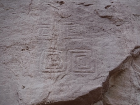
Square spiral petroglyphs in southern Utah. Photo by Gerald Trainor.

A unique set of four square spiral petroglyphs. Do they represent the seasons? I would be curious to revisit this site during the seasonal changes to see if there are any types of solar alignments.

One thing that struck me this trip beyond all else was the amount of time we spend planning, and where that planning can sometimes get us. Don’t get me wrong- planning can be everything, it can mean the difference between a fun, memorable trip and a disaster. But there are times that planning can get in the way of our adventures. Planning can hold us back, it can hold back the explorer in us and stifle the sense of accomplishment, the sense of discovery that we seek out there in the bush.

We live in an overstimulated world with just too much information flowing around us, in our heads and readily at hand. One of the reasons I go into the desert is to escape all that. And I don’t want to bring along a bunch of data- on anything. I want to walk and see and hear things, feel the sand under my boots or under my bare feet, wonder about what is around the next corner.  I don’t want to look for the next thing I am supposed to find at a certain distance from a certain point. Where is the fun in that? For me, that is too much like everything else in life these days- click a link and it’s all there. That is decidedly not what wilderness is about for me.
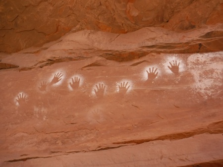
white hand pictographs in San Juan county, Utah. Photo by Gerald Trainor.

White hands- one of my favorite pictographs, and one of the first I “discovered” in southeast Utah about 20 years ago. I visited them again on this trip.

I have never been one to plan an entire trip, hour by hour, water point to water point, camp site to camp site. I know that people do this. There are guide books that do it for you. This is one of the very reasons I don’t use guide books, other than for very general information. My favorite writer of guides, as I have expressed over the years, is Michael Kelsey. He gives clear, concise, to-the-point information, and not much more. That is all I want- mileage to the trailhead for example, if I don’t choose my own, or maybe data on the best way to climb out of a canyon that everyone says cannot be climbed out of. Kelsey’s books are the place for something like that. After that, it is all up to me.

Moving on from my philosophy of wilderness travel back to civilisation, I always end my trips in Moab. I like to mention my favorite local businesses, in support of the community there. Moab Gear Trader has recently moved into the space above their original store. They have so much used and new gear now that it’s easy to find something you can use. I have an account there, and usually drop gear to sell on every trip. You don’t have to live locally to do this- give them a call to see if they may want your used gear. And if you can’t find what you need there, just down the street is Gearheads, where you will find whatever it is you forgot to bring along. There was a time when I would worry about that piece of gear that I inadvertently left behind, but not any more. Between Moab Gear Trader and Gearheads, I know I will find what I need.
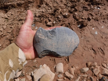
Axe head found in wash in southeast Utah. Photo by Gerald Trainor.

Found in a wash bottom- one large axe head. They artifact had signs that it had been in the wash for some time, and also plenty of use wear. It was made from a perfectly shaped, very flat river cobble.

Gear is good, but we can’t leave out food and coffee to make us happy. Moonflower Coop, on 100 North right off of Main Street, recently completed a major renovation and it is not to be missed. They even  have a seating area now at their deli, where they offer fresh salads, sandwiches, soups, and much more. They are right across the street from Moab Coffee Roasters, one of our favorites. Need a backup bike tube with your coffee? Be sure to visit Moab Classic Bikes on Center Street for both- yes, there is a coffee shop in the bike store. Very convenient!

Our next trip is planned for the end of May- a couple of weeks in the Hanksville area. We are planning, if weather and water levels permit, to walk the Dirty Devil River. No dragging the boat this year! In the meantime, there is plenty more information on desert travels in southern Utah at DesertExplorer.us.


This Way Down, and An Update From Moab

20 March 2016

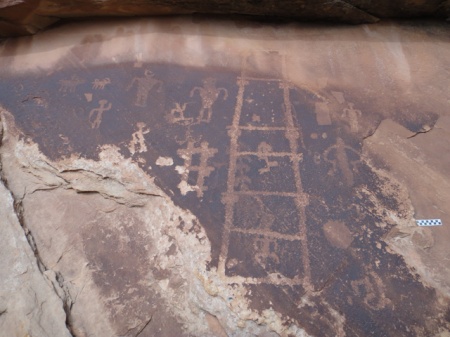
We have been spending a lot of time in Comb Ridge in recent years, stopping in for a few hikes on nearly every trip. We have been in many of the drainages along the southern end, starting at the highway. But there are many more summer’s worth of hikes towards the north. One specific goal this summer is to find at least one of the crossovers into Comb Wash from the Butler Wash side. I understand that there are a couple of them. And I have a suspicion that we may have been in one of the drainages that leads to the other side. A few summers back we here high up one of the canyons, walking up canyon, when we found a small petroglyph panel that had a large ladder-looking inscription. To me it looked just like a kiva ladder. Did the ladder signify to travelers that they could climb down the other side if the followed this particular drainage? This is a question I would like to answer, to see if this was an ancient signpost saying “this way down”.

Kia ladder petro. Image by Gerald Trainor.

Kiva ladder petroglyph from a canyon along Comb Ridge. Scale at right of image is 10 cm.

Update From Moab
We were in Moab in January when news broke about the closing of another missing person case. On the evening of 19 November, back in 2010, Ranger Brody Young was checking on a car parked at the Poison Spider trailhead. The person in the car opened fire on him, hitting him nine times. Range Brody returned fire and apparently hit the suspect as he fled. The suspect’s car was found within a few miles, but he was not found. A manhunt ensued, but was unsuccessful in locating the suspect. Now, five years later, the body of Lance Arellano has been located. A college student home for the Christmas holiday and his younger brother did a systematic search of the area where the suspect was last known to be, and found his remains.  The brothers will split the $30,000 reward. You can read more about the incident on the Moab Times website.

You can read my original blog post and subsequent updates at the Desert Explorer Blog. For more on the 1998 Four Corners Manhunt or all of our desert adventures, visit the Desert Explorer website.


Spring Break Trip Report- March 2014

6 April 2014

We have just returned from one if the most memorable Spring break trips in years. The trip included some of our usual endeavors- seeing rock art and ruins, a bit of gold panning, hiking along Comb Ridge, and plenty of exploring of dirt roads around southeastern Utah. It also included new adventures: a visit to Oljeto, on the Navajo reservation, to see the trading post where the Wetherills lived and then a drive down to the now defunct Piute Farms Marina at what was once part of Lake Powell.

Piute Farms waterfall. Photo by Gerald Trainor.

Piute Farms waterfall, about two miles below Clay Hills takeout, March 2014. The river below actually looked like a river. There were few signs that the lake had made it this far up the channel in years.

We also stopped in at Hite “Marina” (can you have a marina without water?) to take a look at the lake level on our way towards Hanksville. We drove down the boat ramp only to find that we could keep driving all the way across what used to be the lake right to the edge of the Colorado River. And it did look like a river- cutting down through the accumulated silt of the past 50 years and making its way toward the ocean. Looking down river, there was no lake in sight! Looking up river, the Dirty Devil was a muddy little stream braiding its way through the silt and into the Colorado. I can’t help but wonder how long it will take to clean out all that silt…. But more on that in a future blog.

Colorado River at Hite Marina. Photo by Gerald Trainor.

The Colorado River, at Hite Marina. Looking down river, as it makes its way to the ocean.

Silt plain that was once Lake Powell. Photo by Gerald Trainor.

I hope this adds a bit of perspective to what is going on at Hite Marina. This photo was taken at the edge of the river, where I stood when I took the top photo, looking back over the silty, tumbleweed-scattered plain that was once the bottom of Lake Powell. That is our Landcruiser in the middle distance, with the boat ramp far off in the photo.

Back to the archaeology for now. One of our early stops was just outside Blanding to look at a few rock art panels and nearby ruins. We met up with a group of archaeology students, their “tour” leader Daniel Cutrone, the Principle Investigator at the Nancy Patterson site in Montezuma Canyon and professor at California State University Dominguez Hills, and our friend Madalyn from the Edge of Cedars Museum in Blanding.

Nancy Patteson site. Photo by Gerald Trainor.

A central view of the Nancy Patterson site, showing excavated walls and many of the mounds that make up the possible 300 rooms of the site.

Daniel, Madalyn, and their crew kindly took us along on their outings to a few unnamed sites, the Nancy Patterson site, Spirit Bird Cave, and a behind-the-scenes tour of the Edge of Cedars Museum. We were joined on one of the days by Sally Cole, author of Legacy on Stone, among other titles. What a treat it was to look at rock art and not have to pull out our copy of her book for interpretation- all we had to do was listen! The best part for both Nicolai and I was when we were asked if we wanted to return in the summer to be part of the ongoing excavation of the Nancy Patterson site. I haven’t done any excavation in years, and definitely welcome the return to the dirt. For Nicolai, I think it is a dream come true. For more on the Nancy Patterson site, ongoing excavation, and field work possibilities, see the Shovelbums Website.

We spent a few days in Poison Spring canyon, as we often do, enjoying the sites there and some of the slot canyons accessible from the canyon bottom. Next we drove on to Green River town. In and around Green River we explored the abandoned U.S. Army Pershing missile launch complex. What an adventure that was!

Green River missile launch complex. Photo by Gerald Trainor.

The guard shack and associated buildings at one of the main parts of the Green River launch complex.

Abandoned around 1979, the buildings are in a serious state of decay, with doors falling off or missing, fences broken down from power poles falling on them- the power poles having been chopped down by looters stealing the copper wire strung between them! Ceilings had fallen in, windows were mostly broken out, and nearly everything that could be carried away had been. And the few things left on site were well smashed up and thrown into piles in corners. It was perfectly post-apocalyptic in look and feel, including a grey, overcast sky above us. While exploring I kept expecting to round a corner to find a growling pack of ferrell dogs, or maybe zombies, or at least a boy and his father resting as they made their way down The Road. Perhaps that was us?

Tent city concrete pads. Photo by Gerald Trainor.

The concrete pads, perfectly aligned and dressed right, at what is referred to as the “tent city” outside Green River.

Bunker near Green River, Utah. Photo by Gerald Trainor.

Nicolai next to the bunker at the weather missile launch pads.

Either way, let it be known that we never crossed a fence, or a building threshold, as it is still government property and clearly marked as of limits… in a couple of places at least (most of those signs appear to have been stolen.) If you go, be sure to view it from afar.  We spoke to a local deputy who warned us that theft and vandalism have ramped up recently and that they are watching the sites. I have only touched on this marvel of modern science, warfare, our military-industrial complex, and our cold war history. Volumes could be written about it- not by me however. But I do plan to write a full blog about the site, and the Pershing and weather monitoring missiles launched from it in the near future.

Missile launch pad near Green River, Utah. Photo by Gerald Trainor.

One of the main launch pads, with rolling building still in place. There are two other, identical pads, both without the building or even the rails that it rolls on.

For now, we are planning our summer fieldwork, a family backpacking and exploring trip, and a solo trip for me. The summer promises to be a full one- be sure to get out and enjoy it. And watch out for rattlesnakes, they are already out. For more about snakes, and our desert adventures, visit the Desert Explorer website.


Trip Report- November in Southeast Utah

28 November 2013

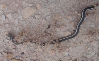
We usually end our hiking season in September at the latest, but that may change to November now based on our recent trip to the desert. Weather was our primary concern- we did not want to be snowed in, stuck in the tent sitting out storms. But luck was with us- the sky was clear and the days were warm, even hot, for nearly our entire trip. It was so warm that side blotched lizards and what I think was a striped whipsnake were still out! We timed our return perfectly and travelled back over the mountains just before the cold and snow returned to Colorado. Next November may not be the same, but if we can stretch our season and spend more time in the desert, we’ll certainly try a late trip again.

Striped Whipsnake. Photo by Gerald Trainor

What I think is a rather dark Striped Whipsnake. This photo was taken on November 15th along the San Juan river. All I have read about them says that they den up by mid-October. Not this year. This snake was high up though, right along a cliff face and getting ready to sleep for the winter.

Most of our time was spent around Bluff and along the San Juan River once again. Nicolai and I hiked nearly every day and re-visited a couple of sites, but mostly explored new areas; new canyons, new dirt roads, new rock art and ruins. While a visit to the desert is success in and of itself, based on the sites we found on this trip I would label it a complete success. We are at a point where we have visited many of the more well-known sites and are just picking a canyon and walking down it. On this trip we picked a canyon north of Bluff and spent a few days walking along one wall of the wide and bushy canyon bottom. We did the same in a few other canyons as well and, as always, needed more time to see all that was out there.

A Few Words About the Archaeology of the Region
As anyone familiar with the area knows, the ancient population density of these currently sparsely inhabited areas was greater than it is today. Of course the population was dynamic, and changed over the thousands of years of prehistory represented in the rock art of the northern San Juan region.  Certain areas were inhabited, abandoned, and re-inhabited later on, other areas were not populated until relatively late, and some were occupied for very long spans of time. The population here was more dispersed over the landscape, taking advantage of available resources including building sites and food and water sources. The larger “villages” were smaller than today’s rural cities and towns, but the “hinterlands”, the areas we are visiting when we walk down the canyons around Bluff, what many see as the empty spaces between the towns (both ancient and modern), certainly had a much higher population. For the record, when I mention “villages” I am not referring to large population centers such as Chaco Canyon or Mesa Verde, but rather those in the peripheral, “rural” northern San Juan region such as ancient Bluff, Hovenweep, and Yellow Jacket.

Moki steps in Northern San Juan region, Utah. Photo by Gerald Trainor

We found Moki steps nearly everywhere we went over this trip. Some of them were definitely needed in order to scale a wall, others seemed really unnecessary, and still others appeared to head to nowhere. Later, Ute petroglyphs were prominent in one area we hiked as well. Note horse in upper right of photo.

A few of the sites we visited had extensive middens, full of lithic debris and pot shards. It was clear that these sites are off the beaten path. Most sites that are found along a roadside or are included in guidebooks are completely devoid of any type of artifacts. Visitors over the years have taken everything away. As an archaeologist this is a painful thought. Artifacts tell a story. When they are found in context- at the location where they were deposited 600, 800, 1000 years prior- they can provide valuable evidence about the people who left them behind. They can inform us about occupation time spans at the site, about how far the occupants may have travelled or how far away their visitors came from, and can tell us about the relative importance of the site and its people. When you visit a site, please leave any artifacts you may find exactly where you found them. Although they may not seem important as you look them over, they may provide important data to the archaeologist who visits the site tomorrow.

Mesa verde black on white pot shards. Photo by Gerald Trainor.

A selection of Mesa Verde black on white pot shards, Pueblo III, about 1200-1300. A few of the sites we visited had large middens that still had hundreds of artifacts on the ground surface. The decoration ranged from hurried and uneven hachures to well thought out geometric designs.

A Drive into Arizona
We took a drive down to Kayenta one day, looping south from Bluff toward Mexican Water and then west toward Dinnehotso and Kayenta, and coming back through Monument Valley. If you have an extra day and feel like seeing some amazing scenery from your car, this is a great drive. Driving south you will see the Chuska Mountains rising in front of you, with Chinle and Canyon de Chelly off in the distance. Turning west you will see Black Mesa out in front, and Comb Ridge on your right. It is a scaled-down Comb Ridge after leaving Bluff, but it is still Comb Ridge. Then of course you will drive through Monument Valley on your way back into Utah. While in Kayenta, be sure to see the Code Talker exhibit- start at the Burger King- yes, that is where a part of the collection is housed. There is a small museum right next door where you can see more. Their hours seem to be erratic, so depending on the day and time of year they may or may not be open. There are plans for a permanent Code Talker museum- you can learn more about that project at the official Code Talker website.

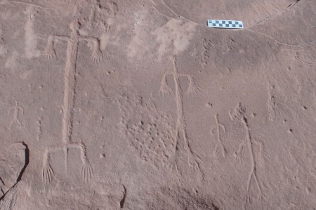
Petroglyphs in the Northern San Juan region. Photo by Gerald Trainor

Lizard figures (?)- part of a much larger panel we found on one of our hikes. Scale is ten centimeters.

Edge of the Cedars State Park Museum
Finally I have to mention one of our favorite museums, the Edge of the Cedars State Park Museum in Blanding. If you travel across southeast Utah on Highway 191 be sure to allow at least an extra hour or two for a museum visit. The museum is just a few minutes from “downtown” Blanding, right on the edge of town. It houses an extensive and impressive collection of artifacts, including pottery, a set of plates carved from cottonwood, and a one-of-a-kind Macaw feather sash. They also have a number of very important finds from Comb Ridge that were found by hikers who alerted archaeologists of their discoveries. Their stories and photographs are included in the exhibits.

Our trip was so full that this single blog does not nearly cover all we saw, or all we wanted to write about. We will do our best to write a second post soon, covering more of the rock art we found as well as mentioning a couple of new pieces of gear we tried out. In the meantime, visit the Desert Explorer website for more about our desert adventures.


Trip Report- Spring Break 2013 in Southeast Utah

15 April 2013

We have just returned from another exciting Spring break trip to southeast Utah. We made the usual rounds, from Cisco down to Bluff and Mexican Hat, across Cedar Mesa, back up through Hanksville to Price, and on to Green River and Moab for a day. The weather was varied as it always is this time of year- from freezing cold and strong winds, to sunny, warm, summer-like days. You just never know what you’ll get in Spring in southeast Utah and it is important to be prepared for everything from sitting out snowstorms in the tent for a few days, to having plenty of sunblock and your shorts and river sandals on hand.

Comb Ridge
One of the highlights of our trip included five days of camping near the San Juan River outside Bluff, and hiking there and in Comb Ridge. We also hiked along the river, including a look at the panels around Sand Island, and up some small side canyons right from camp. But most of our time was spent in the middle part of Comb Ridge.  We managed to see five of the canyons there with ruins and rock art around every corner. We did our best to hike up one canyon then down another, but as anyone who has been along Comb Ridge knows, there are plenty of pour offs to send you back the way you came or at least send you looking for another route.  The good thing about Comb Ridge is that the canyons are all short, and backtracking is never a big deal. Comb Ridge was a busy place, with lots of hikers and people camping at nearly every site along Butler Wash. Keep this in mind if you plan a visit over Spring break.

A kiva in one of the Comb Ridge canyons. Photo by Gerald Trainor.

A kiva in one of the Comb Ridge canyons.

Tracking Practice
We did take advantage of having to backtrack from a couple of the canyons, using it as a chance to work on our tracking skills and to see a different part of the lives of the ancient inhabitants along the canyon mouths- including ancient campsites, lithic scatters, and storage cysts. Some of the approaches were long for us (we didn’t drive to a different “trailhead” for each canyon, but worked our way along the ridge from one). The walks back along these routes allowed us to find our tracks coming in, examine them for changes based on the weather and other hikers, and follow them back to our start point.  Again, being Spring break, there were plenty of other hikers out- because of this we were forced to use the lost track drill a number of times, casting about for our tracks among others, and doing the same out on the flat where we made it a point to use anti-tracking measures on our way in. By anti-tracking, or counter-tracking, I mean simply trying to walk as carefully as possible so as to hide our tracks- walking close to brush in shadows, through heavy, well-traveled brush, and across slickrock patches wherever we could.  In doing so we benefited going out and coming back.

A grooved stone we found on our approach to one of the canyons. Scale is in centimeters.

A grooved stone we found on our approach to one of the canyons. Grooves are on both sides, running parallel. Pictured side is the more pronounced. Scale is in centimeters.

The Dirty Devil River
After our stay in the Comb Ridge area we headed west and spent a night near Hite on the rim of the Dirty Devil River canyon.  The river was flowing at about 150 CFS then, but the mud chutes at the end of the river and directly flowing into the Colorado at this point were not promising for a float. It looked like a muddy mess ready to capture anyone who stepped into it.  The lake was so low that the Dirty Devil actually flowed into the Colorado River, and together they flowed off into the distance, a thin stream of a river in the middle of a vast horizon of mud.

Dirty Devil River as it flows toward the Colorado at Hite Crossing.  Photo by Gerald Trainor.

Dirty Devil River as it flows toward the Colorado at Hite Crossing. A murky thread of water through dried mud.

We stopped for a day in the Irish Canyons in North Wash, and then spent a night at Angel Point and had a walk down to the Dirty Devil River the next day. The river looked much more floatable from this point, really looking like it was flowing at 150 CFS and without a sandbar snag in sight. We recently had some comments and questions on putting in there. Aside from the walk down to the river- across slickrock, rocky with exposure in a few places, and bushy in others, the river looked good. The party mentioned was using 5 pound pack rafts- we are still waiting to hear the outcome.

Nine Mile Canyon
Next was a visit to Price and the College of Eastern Utah Museum. The museum houses a collection of artifacts from the surrounding region highlighting, among other things, the Fremont culture.  There is also an impressive paleontology collection. If you visit Price, or even find yourself driving through, the museum can be found right in the center of town and is worth the stop. From Price it is just a 15 minute drive south to Wellington and the turn off into Nine Mile Canyon.

A well known pictograph in Nine Mile Canyon. You may have seen this one in National Geographic- the damaged happened long ago before the state intervened on behalf of history.

A well known pictograph in Nine Mile Canyon. You may have seen this one featured in National Geographic.  The damage happened long ago before the state intervened on behalf of the preservation of pre-history here.

The name of the canyon is deceiving, being some 70 miles long in total.  The road through the canyon has been recently paved, and is in perfect shape. The is a short section mid-way that remains unpaved, but any vehicle can make it all the way up to the Big Buffalo and Great Hunt petroglyph panels, some of the highlights of the canyon. We turned around there and backtracked, but you can continue north from about mile 37 to Myton. In my opinion, the canyon has more than can be seen in a long day, especially if you plan to do any of the hikes-there are countless rock art site, ruins, and many points of historic interest.  Note that camping is not allowed anywhere in the canyon, other than at the Nine Mile Ranch private campground. So plan accordingly and start your trip into the canyon early, allowing at least a full day.

Great Hunt panel in Nine Mile Canyon. Photo by Gerald Trainor.

One of the more well-known panels in Nine Mile Canyon- called the Great Hunt panel.

Gear Reviews
I always try to highlight a piece of gear in each blog, and for this post I have chosen Rite in the Rain notebooks and Fisher Pens.  It is hard to imagine one without the other. Rite in the Rain notebooks come in many different sizes and page formats, but I tend to use one of the originals- the 3 by 5 inch, spiral top notebook.  It fits easily into any pocket and with its plastic cover, it is virtually indestructible. But the key feature that makes Rite in the Rain products so important to someone who spends a lot of time outdoors is that the pages are waterproof.  I have swam with my notebooks, used them in monsoon rains where I have been soaked through, taken notes during archaeological fieldwork sessions in dripping Central American jungles, and used them for years while in the military. I cannot say enough about the quality and functionality of their products. You can see the spiral bound notebooks and Fisher pens at TwoHandsPaperie.com.

Rite in the Rain notebooks- photo by Gerald Trainor.

Rite in the Rain spiral notebooks- a collection from over the years, including one of Nicolai’s. Archaeological fieldwork, river trips, bikepacking trips, and backpacks are all recorded here.

Fisher pens are the perfect companion writing instrument for the waterproof notebooks. Fisher pen refills are pressurized, and will write upside down, in any temperature you might normally encounter, and on wet Rite in the Rain notebook pages. The Stowaway Pen with a clip is the perfect pen for the 3 by 5 spiral top notebook- the pen slides right into the spiral and clips into place. This pen is also about the most lightweight pen imaginable. The only thing lighter might be just a pen refill by itself! The refills last an incredibly long time as well, and perform perfectly in the desert, mountains, or jungle.

Rite in the Rain spiral notebook with Fisher pen, Photo by Gerald Trainor.

Rite in the Rain 3 by 5 inch spiral notebook with Fisher Stowaway pen securely fastened in spiral binding.

For more on our desert adventures, tracking, and rock art, visit the Desert Explorer website.


September Trip Report, Part Two- Chinle, Comb Ridge, and San Juan Rock Art

18 November 2012

In my most recent post I wrote about the first part of my September trip to Southeast Utah. This post completes my trip report.

My next stop after Grand Gulch was Chinle, Arizona. I made the trip south in order to attend the KTNN radio Drums of Summer celebration. It was the second to last gathering of the summer and being only a couple of hours away I made it a point to take the drive. KTNN radio, the Navajo Nation’s radio station, hosts the Drums of Summer celebrations throughout the summer every year. They are held around the reservation, often in local school auditoriums. They consist of Navajo singers and drummers performing for the audience, along with space for attendees to dance. There are countless raffles and giveaways, and at this particular event there was a pinion fire burning outside with fresh frybread cooking on it. The gathering was in honor of seniors, many of them as I understood it, from the local Chinle senior center. Most of the dancers were older Navajos, and really seemed to be enjoying the event. I spoke to one of the directors from the center for a while, and he told me of the importance of seniors in Navajo culture. I had given this some thought already upon realising that there was in fact a senior center for aging Navajos, people who traditionally would have been cared for in the home by family members, rather than in a western, institutional setting. I sensed that the director was concerned himself with this fact but resigned to it, that it was in the present day unavoidable. He also expressed his dismay with some younger Navajos, telling me how so many seemed to be abandoning their own culture and language in favor of the western world, something I have heard many times from older, more traditional Navajos.

After a night in Chinle I headed north again to Comb Ridge. I was joined on one day of hiking there by two Army medics who were visiting the Chinle area. It was a great opportunity for me to introduce them to the prehistory of the region, and for all of us to make some discoveries in the canyons. I had been along Comb Ridge on both east and west sides many times. I had examined various rock art panels along the way, camped there a number of times, used it to access the eastern drainages of Cedar Mesa, but never really done much hiking there. It has always been my understanding that parts of Comb Ridge were as densely populated as Grand Gulch in prehistoric times, although on a  much smaller scale.  Anyone who has visited the Edge of Cedars Museum in Blanding will note that many recent additions to the museum, and some very important ones,  have come from the Comb Ridge area.

Ruin along Comb Ridge, Utah. Photo by Gerald Trainor.

A ruin in one of the many short canyons along Comb Ridge.

There was also the recent discovery of skeletal remains along Comb Ridge thought to be those of the long-lost traveler Everett Ruess (in the end it was not Ruess). I have to admit that I always found the amount of archaeology from Comb Ridge hard to believe, considering that the canyons are so short. The distance from Butler Wash on the east to the crest of Comb Ridge is not more than a couple of kilometers on the average- very short in terms of resource availability, both food and water. But then I must consider Butler Wash itself, and the fact that Comb Ridge consists of many, many of these short canyons side by side, running east to west, for miles and miles. Also, the tilted Navajo sandstone of Comb Ridge creates perfect building locations, although not as defensible as the shelves and benches of nearby Grand Gulch and its associated drainages, and provides for some canyon-bottom farming locations.

View west from top of Comb Ridge. The drop to the west at this location is about 700 feet down to the road at Comb Wash below. Taken with iPhone panorama application by a fellow hiker.

Those who have read my blogs in the past know that I do not like to give too much away, that my intentions are to leave the discovery to the individual by not providing grid coordinates, maps, or even trail directions. With that said, Comb Ridge is a place that seems to me to allow for endless discovery. Not only that, but the hiking, in my opinion is fairly easy- my 8-year-old son and I will be there visiting the canyons together on our next trip to Utah. You can expect to see cultural and geologic wonders, and an unmatched view if you hike up to the ridge at just about any point along the way.

Detail shot of eastern end of a very large and distinct petroglyph panel along Comb Ridge.

After Comb Ridge I spent a couple of days around Bluff, and took a look around Sand Island, the primary launching point for floating the San Juan river. Besides the boat ramp, you will find rangers in residence, campsites, picnic areas, toilets, water, and petroglyphs. The main, Lower Sand Island petroglyph panel is easily accessible from the road leading into the campground. You can in fact view the panel from your car window if you so desire. It is an extensive and busy panel that covers more than 2000 years of prehistory. 

petroglyph panel near Sand Island, San Juan river, Utah.

One of the many panels near Sand Island, showing animated, possibly dancing figures.

There are many other panels up and down the San Juan from the same time period and possibly much, much earlier. And by much earlier I mean much earlier, with probable representations of Pleistocene megafauna- between 11,000 and 13,000 years ago. The panel I am specifically referring to is known locally as the “Bluff mastodon panel”, but likely represents Columbian Mammoths, two of them, and a possibly coeval, superimposed bison. See the paper in the journal Rock Art Research from 2011 for extensive background on the panel. The paper offers a very clear description and analysis of the panel and supporting arguments for the date that are very convincing. As the paper also points out, there are likely a panel or two from the same period still waiting to be found, and plenty of discoveries within the panels along the San Juan river waiting to be made.

For more on our desert adventures, the San Juan river, and rock art, visit the Desert Explorer website.


September Trip Report, Part One- Fish Creek Canyon and Grand Gulch

13 October 2012

I was lucky enough to have the last two weeks of September to myself in the Grand Gulch area of southeast Utah this year. I managed to spend about a week in Grand Gulch and on Cedar Mesa, and a few days hiking Comb Ridge. During my hikes I found countless rock art panels- a few that I revisited, but many new ones, and ruins all along the way. I also made a side trip down to Chinle, Arizona for an evening of Navajo singing and dancing sponsored by KTNN, the Navajo Nation’s radio station. The weather was perfect, not too cold, and warm during the day. There was one night and morning of sustained rain while I was down in Grand Gulch. There was enough rain to send water cascading off canyon rims and to turn the previously dry canyon bottom into a fast-moving stream.

My hikes started out with a few days in upper Fish Creek Canyon- 3 days and 2 nights to be exact. I entered from the Fish and Owl trailhead and then walked up the Main Fork and came back down the South Fork. This was a section of canyon I had wanted to visit for at least the last ten years, ever since my first trip into lower Fish and Owl Creek Canyons. The head of the canyon seems very inviting as you drive across it on Highway 95. Looking down canyon, it appears that it would be a gradual, even descent on slickrock canyon bottoms. This is not really the case, especially up high.

Entrance to Fish Creek Canyon, view north from canyon rim after walking across mesa. The walk is rough in the canyon bottom down below.

Since I was traveling alone and not carrying any technical canyoneering gear (no ropes, harness, slings) I started from below and worked my way up. It always feels safer to me to work this way- if I can climb up something I can usually climb right back down it. Coming in from above and following the canyon bottom in an unknown canyon often requires a lot of climbing out- around- back in. This adds the potential for becoming “rimrocked” while trying to find a way back in. Then there is the possibility of downclimbing and coming to impassable pouroffs requiring backtracking and climbing back out. Of course the same will then be true for traveling up canyon, but the potential for getting into trouble is minimised, in my opinion, by traveling up canyon.

Upper Fish Creek Canyon is not lower Fish Creek Canyon, not that lower Fish is that easy of a walk. The canyon started out with water everywhere, and associated brush, requiring lots of skirting of pools, and some climbs around bigger pools at pouroffs. I found pools of hundreds and even thousands of gallons of water on my hikes in Fish Creek, Grand Gulch and side canyons.  I should mention that just a couple of weeks before my arrival there was a tremendous downpour lasting some 10 hours at certain locations. This filled the canyons with water, scouring them out and depositing debris, and creating problems for navigation both in the canyons and on the mesa top. I was told by the rangers at Kane Gulch that “the narrows” of Grand Gulch had become a swimming hole at the bottom, and was jammed with debris at the top. There was a group of volunteers clearing out brush and rebuilding trails in that area while I was there.

Pothole- upper Dripping Canyon, Cedar Mesa, Utah. Photo by Gerald Trainor.

Large pothole holding thousands of gallons of water, upper Dripping Canyon.

Back to Fish- canyon bottom walking was rough at times. Besides water and brush, there was plenty of climbing over, under, and around boulders higher up in the canyon. Slots were a problem higher up, requiring climbing out, skirting on a bench, and climbing back in. The vegetation changes as I gained elevation traveling up canyon occurred in conjunction with the slots- once I started seeing Ponderosa and other pines, the canyon narrowed and started to slot. I encountered more slots coming back down the South Fork than moving up the Main Fork. A rope, harness, and some slings would have made for an interesting experience in these upper sections.  I spent a few hours on benches skirting slots on  the way back down.

Slot in upper Fish Creek Canyon, South Fork. Don’t be deceived by the photo- it is about 40 feet or so down to the water. This would have been fun with rope and harness.

After I finished up with Fish Creek Canyon I headed across the mesa into Grand Gulch proper. I entered via Dripping Canyon, which is passable. That is about all I will say on the subject; it is a fun one, and can be done. I spent the afternoon in Grand Gulch and headed out via Step Canyon, where I stayed the night. Along the way I passed by some of the well-know panels and ruins in the canyon bottom. If you are new to Grand Gulch, it was at one time very populated. This is evident as you walk along the canyon bottom; all you have to do is look up every now and then to see ruins and rock art.

Pueblo dwelling, Grand Gulch, Utah. Photo by Gerald Trainor.

Large, well-preserved, and defensible ruin in Grand Gulch.

Part two of my September Trip Report will cover hikes in Comb Ridge, rock art along the San Juan River, and my visit to Chinle, Arizona. I will also include an update on my tracking book bibliography. Look for that in about a week. In the meantime, for more on visiting southeast Utah, see the Desert Explorer website.


Spiders and Beetles, Dalton Wells, Great Horned Owls, and Escalante Photos

8 August 2011

The summer is a busy time for us- busy and fun- and this summer has been one of the busiest in recent years. We have been travelling since March, barely home at all. We’ve seen and done so much that it is hard to keep up with it. This will be a quick post- a follow-up on a couple of earlier posts, and few words about our most recent trip. And as soon as I finish this one, we are off again- we have a permit for the San Juan River next week. Look for a post from that trip in a few weeks time.

Spiders and Tamarisk Beetles
As luck would have it, Nicolai and I found ourselves with some free time a couple of weeks back, and we weren’t too far from Green River Town. We stopped in town for a cup of coffee and some ice for the cooler. Then we made a visit to Crystal Geyser where we had a swim in the still-swift Green River and spent a couple of hours waiting for the geyser to blow. The geyser wasn’t too active, but we did get to talk to a researcher from Grand County who was checking the condition of tamarisk trees and the resident beetle populations. He happened to be checking a group of trees that were covered with those big spiders that we have encountered on our floats down the Green, so we asked for more information about them. He couldn’t tell us specifically about the spiders, but he did say that they seem to be following the beetle populations. It seems that they are feeding on the beetle larvae. He said that in that area in particular he had noted a couple of groves that were covered with the spiders. It seems that the beetles do have a natural, local enemy, a question I am sure that researchers asked when they were deciding whether to allow the beetles to be released.

Unidentified species of spider at our camp at Crystal Geyser. This photo was taken on our float of the Green River in 2009.

Moab and Dalton Wells
On that same trip we made a visit to Moab, as we usually do. This time we did some driving around on roads and trails in the Sovereign area  north of town. One of the entrances to the Sovereign trail is through Dalton Wells, a historic site located just off the highway. It is on the National Register and there is an interpretive plaque explaining the history of the site. Dalton Wells began as a Civilian Conservation Corps camp and was in use for that purpose from 1935 to 1942. It was one of four camps located in the Moab area. The CCC members were responsible for countless projects in the Moab Valley and surrounding area during the years the camp was in operation. These projects were initiated by the Soil Conservation Service, the National Park Service, and what would become the Bureau of Land Management and included building stock trails, water development projects, range improvements, and fencing and pasture work.

From January through April of 1943 the Dalton Wells CCC camp became the “Moab Isolation Center”, one of many relocation camps for Japanese Americans during World War II. The camp was used for this purpose only briefly, and housed “troublemakers” from such camps as Manzanar in California and Gila River, Arizona. At most it housed about 4 dozen men, who were eventually transferred to the indian school at Leupp, Arizona on 27 April, 1943.

There are a couple of websites with more information on the camp- one is the Utah State History website, the other is the National Park Service page on Citizen Relocation Centers. The latter page has a couple of photos of the camp.

Great Horned Owls
In April we made a visit to Phoenix and Tucson where we visited the Arizona-Sonora Desert Museum among other locations. There is  a blog post about that trip for those interested in reading more. In Tucson we stayed in a hotel in the foothills that was also home to a Great Horned Owl and her two young ones. The owlets lived in a large planter box surrounding the deck of a second floor room of the hotel. It appeared that the hotel was respecting the owls by keeping the associated corner room vacant. Our room was right next door to the vacant room and so we had a great view of the owls, day and night. During the day the mother would sleep in a nearby pine tree, up high near the very top. The owlets would huddle together in the corner of the box, as far from onlookers as they could get. At one point the mother brought in a cottontail for the owlets to eat. They moved the rabbit around a bit, and we got to watch one of the owlets have its morning meal. At nights the mother and young ones would perch on the edge of the planter box, keeping a close eye on everything through the night. The mother would fly off and return all through the night, and would leave early in the morning for her daytime rest in the pine tree.

Mother and owlet Great Horned owls at their hotel room in Tucson. Photo by Gerald Trainor.

Mother and owlet Great Horned owls at their hotel room in Tucson. The owlet to the right that is bent over was only concerned with its rabbit breakfast. Most of the rabbit is in the foreground near the cactus.

Owlets in the planter box, Tucson. Photo by Gerald Trainor.

Owlets in the planter box.


Owlets huddling together for their daily rest in the early morning. Photo by Gerald Trainor.

Owlets getting ready for their daily rest in the early morning.

Final Words on Escalante Trip

I have covered nearly everything I wanted to regarding my Escalante Trek in recent blog posts. The only loose end was posting photos of the trip. I have finally done that. A series of photos from the trek is up on the Desert Explorer Picasa page. For more on our desert adventures, desert backpacking, floating and general information, visit the Desert Explorer website.

Escalante Trek, May 2011- Geology, Rock Art, Tracking, and Poison Ivy

8 July 2011

This is the third part of my May 2011 Escalante Trek blog posts. There was so much to see along the way that it was impossible to cover everything in a single post. Part one covered the trek itself, part two was gear reviews. In this post I will touch upon rock art, geology, flora, and tracking practice while hiking. It is a lot to cover I know, and this post will just scratch the surface of these topics. I am still planning a post on Leave No Trace Principles, and probably a separate post on access issues on public lands. I have seen a lot in the news lately- in the Moab, Blanding, and Monticello areas- regarding problems accessing roads and campsites that folks have been visiting for 10 or 20 years. I have had emails regarding the same. It is a topic that demands careful attention, and I will start soon with visits to a couple of BLM offices in southeast Utah to ask some questions. But for now, it is back to the Escalante.

Geology
Whenever I find myself in a canyon I am always captivated by the countless millions of years of geologic history in front of me. And I always wish I knew a bit more about what I was seeing. The Escalante area is no excepotion- it is a geologic wonder. With so many different formations and so much geologic time represented there, volumes could be written on the geology of the area. Oddly, a thorough search of the internet yielded very little information about exactly which formations you are walking through as you make your way down the river, at least if you are a novice geologist. If you can read a geologic surface map, or follow a technical paper written specifically for geologists, then you will find some detailed data available. I had expected to find a geologic map of the canyon bottom for the hiker walking down the river, but found very little other than references to the formations themselves. And those were not specific. So the task remains for a geologically minded canyon bottom hiker to give us such a map. I’d really like to see one.

thin sheet of quartzite material on navajo sandstone slab, escalante river, utah. Photo by Gerald Trainor.

Thin sheet of quartzite, about 1/8 inch thick at most, on a slab of Navajo sandstone along the river. This was a rather common occurrence on the lower section of the river.

From the Moody Canyon trailhead I began my walk in the Wingate and Chinle formations, which apparently dip down and disappear at the river. Most of what I walked through was Navajo sandstone, in the lower part of the river canyon, and up Coyote Gulch.

While I wish I knew more about the specifics of what I was viewing- the depositional environment, the minerals that caused the specific colors, and the events that caused the folding, bending, and dipping- enjoying the imposing beauty of the vertical Navajo sandstone walls, the fluted columns of the Wingate sandstone, or the colorful Chinle shales is usually enough. Not much needs to be said about the Navajo walls- for me they represent the desert canyons with their dark, patinated, vertical walls reaching hundreds of feet high, and the occasional arch such as Stevens arch near the mouth of Coyote Gulch.  

The Chinle formation is one that I have not had much experience with, but on this trip I got to see and feel it up close. On my last day of walking I had to cross through it on my way up and out of East Moody canyon. It was a wet day and the clayey material, revealing ancient swamps and waterways, stuck to my boots, more with every step, until each foot weighed 10 pounds more. But the moisture only added to the beauty- the purples were deeper, the greens brighter, and the extra weight on my feet just added to the adventure.

Another unique geologic feature that I have wondered about for years are “Moqui marbles”. These are round or near-round sandstone spheres varying in size from BB-size up to an inch or more in diameter. I have found them on the mesa top in the Escalante in a few different locations. Don’t confuse Moqui marbles with tumbled sandstone “marbles” found in stream beds. The formation processes for each are completely different. Moqui marbles are formed during the deposition of sand as iron froth-coated air bubbles in very wet sand. Eventually they weather out of the parent material and are found, in the Escalante at least, in large concentrations making their way down gentle slopes.

"Moqui marbles"- ironstone concretions found weathering out of sandstone. Photo by Gerald Trainor.

"Moqui marbles"- ironstone concretions found weathering out of sandstone.

Rock Art
I encountered only a few rock art panels along the river, and a few in Coyote Gulch. As it usually goes, I likely walked by at least as many as I saw. They will be there for the next trip. All of the panels that I saw were small in size and number of elements compared to most panels I have seen both in and out of the area. Perhaps it has something to do with the rough nature of the lower part of the river canyon. The early inhabitants likely chose more hospitable locations for hunting and living and making art, if in fact it was art. Excluding one panel in Coyote Gulch, all were petroglyphs. Coyote Gulch has a few impressive panels, one of which is a pictograph of at least 5 near life-size anthropomorphs. For me, there is nothing quite like finding rock art. And finding life-size human figures staring down at me from a canyon wall, knowing that they have been there for hundreds of years, is really a humbling experience.

A small rock art panel along the lower Escalante River. Photo by Gerald Trainor.

A small rock art panel along the lower Escalante River.

Tracking
Whenever I walk in the canyons I am always on the lookout for tracks. I search them out not only to identify them, but also to follow them. This is how you learn to track- by finding and following them, by reading them, and by building a profile of the quarry you are tracking. On a previous trip in the Escalante, on the upper part of the river, Robert and I made it a point to follow the turkey tracks that we found all along the river. Not only did we practice finding and following the freshest tracks, but after a while we found that the turkeys led us to the easiest paths and around obstacles.

On this trip I found the usual turkey, beaver, coyote, fox, and of course human tracks. Walking along the river margin, in many places there was only a narrow strip of dry land. I followed the tracks of a previous hiker through much of that. It was interesting to see where this person chose to cross the river, when to climb through or over or under obstacles. By following any set of tracks, after a time you begin to build a picture of who or what made the tracks, and you can begin to anticipate their next move. In this case it was a male traveling alone, on the river for days, and with plenty of experience in route finding and canyon bottom travel. Even when I stopped looking for the tracks, I found that I was still following them, that this person and I shared our choices for a route down river.

A Quick Note About Poison Ivy
Poison Ivy is found all along the Escalante River and in many of the side canyons. The river corridor, and the side canyons draining into it, tend to be very wet. They are perfect locations for Poison Ivy to thrive. Keep your eyes open for the stuff- you will find it everywhere there is a constant source of water. If you come down Scorpion Gulch, be especially watchful. The narrows down near the river require either careful wading through the potholes, or more careful squeezing and scrambling along the stream edge. Either way you will be negotiating a Poison Ivy jungle. I have taken to wearing long pants most of the time and also carry a small bottle of Tecnu, a soap made specifically to combat the oils deposited on the skin when you brush against the plant. 

Poison Ivy in a relatively dry location just up Fool's Canyon form the river. Photo by Gerald Trainor.

Poison Ivy in a relatively dry location just up Fool's Canyon from the river. It gets much thicker further up canyon where spring-fed pools of water are common.

For more on the Escalante Region, Poison Ivy and other desert flora, tracking and geology, visit the Desert Explorer website.


Escalante Trek, May 2011- Moody Canyon to Coyote Gulch and Back

27 May 2011

Wind, clouds, rain showers, and cool weather- this summarises the eight days I took to “finish” my trek of the Escalante River. I know it is still spring, but I had hoped for more summer-like weather. I began on the 12th of May at the Moody Canyon trailhead, about 20 miles down the Wolverine Loop road from the Burr Trail. The road to the trailhead is well maintained, and if dry it is not really a problem for almost any vehicle, although a high clearance, 4WD is recommended in case bad weather does move in. From the trailhead I walked for 8 days to complete a loop back to my start point. Along the way I saw a few rock art panels, endless geologic marvels, was serenaded by flycatches and towhees, and had an overall terrific experience alone in the bush.

Swimming the Escalante
My first day took me down to the river. On day two I walked up river to 25 Mile Wash and back to “connect” this walk to my 2009 walk from the Highway 12 bridge down to and out 25 Mile Wash. After that the walk really got interesting. The weather grew cooler, wind blew, rain fell, and the river got rougher with every kilometer I walked down it. River crossings- there were at least 25 each day- were deeper, swifter, and colder as I got further down river. I had to swim on a number of occasions, floating my pack alongside me. A note on crossing rivers- as a safety measure when crossing swifter water always unclip your breast strap and waist belt and at least loosen your pack straps, or remove one arm entirely. If you should happen to lose your balance and fall in the current it is far better to swim out of it without a backpack strapped to you, which can become quite dangerous in some circumstances. By the last day of walking down the river the flow had peaked, and as I got closer to the mouth of Coyote Gulch, within a few kilometers, it began to calm and become shallow. This was mainly due to the height of the water in the reservoir below.

View of the Escalante River below Scorpion Gulch looking up river, photo by Gerald Trainor.

View of the Escalante River below Scorpion Gulch, looking up river. Note the boulders and tight margins along the water that must be negotiated. It gets tougher the further down river you get.

Floating the Escalante
Coyote Gulch is about where the Escalante starts backing up and the flat water below begins, although this year water was still flowing on past Coyote Gulch. I met a few groups of boaters along the way. All were in inflatables and two of the groups were taking the smart way out, floating all the way down and meeting a boat to shuttle them back to Bullfrog. I am told this will cost about 350 dollars or so per shuttle boat. Even if you go solo, you can try to link up with another group and split the cost of the shuttle boat out. The other option is to haul all your gear up and out Coyote Gulch, something not very fun with just a backpack, let alone a boat and river gear. Currently there is only one portage on the lower part of the river, a large boulder jam that has been there for years. Depending on the flows, there may be more than this one. The river was flowing around 100 CFS during my trip according to the USGS website, but apparently that number doubles once you reach Boulder Creek. Current river flows can be found at the USGS website.

The Loop
To finish out the trip I walked up Coyote Gulch to Dry Fork of Coyote Gulch, across the mesa to the head of Scorpion Gulch, back down to the river, up river to East Moody Canyon, and out from there. It all sounds fairly easy, but don’t be fooled. It was a long one, just over 100 miles, and although the bushwhacking wasn’t too bad as compared to conditions on the upper part of the river, the river crossings and negotiating the river banks more than made up for that. Navigation was not much of an issue- follow the water down to Coyote Gulch, walk up, cross the mesa, and so on. Of course there is more to the walk than this, but for the sake of rambling and spoiling the adventure for anyone else who might choose to do it, I will stop the narrative here.

A pool of fresh, clean water about mid-way down Scorpion Gulch. Photo by Gerald Trainor.

A pool of fresh, clean water about mid-way down Scorpion Gulch.

Trip Summary
It goes without saying- but I am going to say it- that you should be prepared for this hike. Carry the gear that you will need, don’t overpack, and be in shape. There was really nothing too technical anywhere along the 100 miles of the loop other than a bit of bouldering and crawling though a few cracks here and there along the river. There was no climbing or rappelling, no need for technical gear unless you explore further up some of the side canyons such as Fools Canyon. You can walk up Fools a couple of kilometers before you reach a pouroff that requires rope and harness to get around it. From there it’s anyone’s guess.

In my experience, May is a good time to do this walk, with the chance for cool weather and lower river flows.  Average river flows are around 10 CFS for May- but they could be at 200, 300, 400 CFS or higher. Temperatures should be around 75 or 80 with a sunny sky- they could be 35 or 40 with clouds and rain. Bugs were not an issue, but they certainly could be, especially if you visit later in the summer. A point of note- do keep your eyes open for poison ivy. It is all along the river, and up and down many of the side canyons, especially the lower sections of Fools Canyon and Scorpion Gulch.

Water was not an issue anywhere and excluding the river entirely, there was plenty of water in every canyon, just around every corner at this time of year. I didn’t have to filter any of it, I just filled my bottles and treated the water with the MSR MIOX purifier pen. You can read more about the MIOX at the Desert Explorer website. This fact helped to keep my pack weight down. For the most part I didn’t carry any more than a few liters of water on my back at any given time. Again, the water situation could change dramatically from year to year, and as it gets later in the summer. For more on ultralight desert backpacking, backpack foods and meals, water, and desert adventures, visit the Desert Explorer website.

Part Two
Check back in a few days for part two of this post, where I will review the new gear that I tried out on this trek including the Golite Trinity Malpais jacket, OTB DesertLite Boots, and Rokit Fuel endurance foods. You can also read our gear reviews from the first part of the trek– we tried out Sea To Summit pack liners, the Sealine HP  map case, and a Drypack case for the digital camera. I’ll also touch on the geology and rock art that you might see while walking down the river, as well as a little about the flora and fauna.