Urban Tracking Exercise

23 September 2016

On  a recent morning I took an early walk to our local coffee shop. After getting a cup of coffee, I continued on my walk to another destination a few blocks away. But as I rounded the first corner and was about to cross the street, I noticed a coin at my feet- a dime. I thought”I should pick that up”… and then I noticed another. Next thought, “I’ll pick up both f them.” But then I noticed something else shining out in the middle of the street. Scanning the area, I picked up 4 or 5 more shimmering coins in the early morning sun. I picked them all up and stood pondering some 55 cents in my hand and why the coins were there: there was a parking space nearby- perhaps someone getting out of a car dropped them? But they were scattered, too far from the parking space, out into both directions of traffic. My tracking exercise for the day had begun.

While nearly all of my tracking training takes place in the bush, and most of it in Utah, I will take any challenge I can get. Not only did a few coins on the ground offer me an opportunity to track, but it offered a mystery to ponder: why were coins scattered in the street? It didn’t make sense that they were dropped exiting a car; how did they get distributed as they did? And why did someone not pick them up after dropping them?

After pocketing the coins I walked off towards the west, down the middle of the street (I was still in a small parking lot), scanning carefully, looking for more “sign”. I quickly picked up more dimes, and a few nickles. Standing at an intersection in the parking lot, I had lost sight of sign ahead. West lead to an empty stretch of road for a while, then to another small strip mall. Instead I turned around toward the east and walked in the direction of many blocks of apartment buildings.

Urban tracking exercise- beggining of sign.

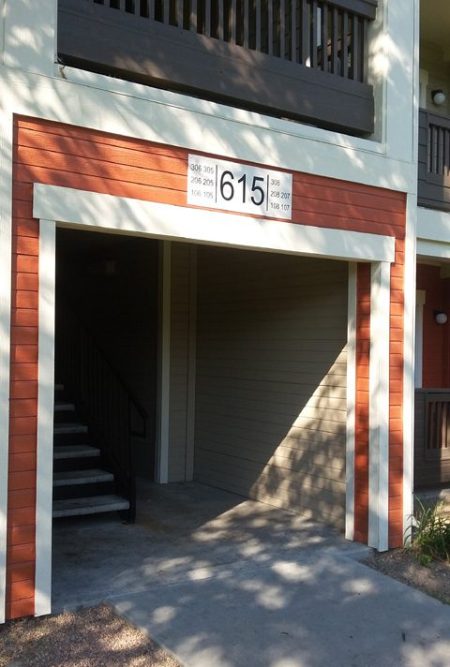
Apartment breezeway where sign trail began.

To shorten what could be a long and detailed story, I spent the next hour slowly walking down streets- usually close to the gutter and sidewalk, and with traffic for me, crossing the street a couple of times, down sidewalks, through apartment parking lots, through breezeways, and even through a play area and around an apartment’s pool area. By the time I arrived at the east end nearly an hour later I had two pockets full of change. This end- which was undoubtedly the beginning for the dropper-of-coins, was at a staircase in a breezeway leading to 4 upstairs apartments in one of the complexes. I confirmed the lack of further sign by casting out in all directions from my last definite sign, essentially doing a lost track drill from the base of the stairs, not once but twice. Not a coin was to be found. Next I backtracked, double-checking, finding a couple of missed coins, all the way to my western-most point. I cast out from there and found the trail once again. It only lead me a little further along the road just across from the strip mall, and essentially to the front of a small shop that sold cigarettes.

Urban tracking exercise- coffee money for the week.

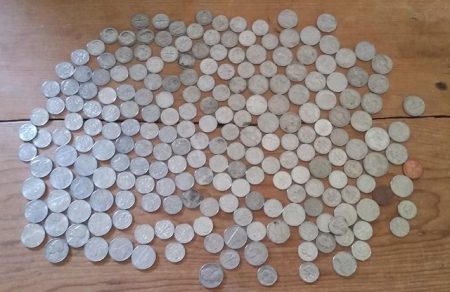
The outcome of my exercise- about $20.38- coffee money for the week.

My conclusion about my exercise: a person had left their apartment building possibly in a time of limited light (the reason they may not have seen the dropping coins) and/or because they had ear buds in their ears and couldn’t hear the coins dropping. They either held the coins in a bag (a plastic shopping bag perhaps as they always come with a ready-to-tear seam in the bottom), or more likely in an unzipped pocket, or pocket with a small tear, of a backpack. They likely rode a bicycle (many were found locked at the bottom of the apartment stairs) towards the strip mall end-point. The bicycle theory is based on the winding trail of coins, the fact the more coins were found where the quarry rode off a sidewalk onto the street (the bounce forced more coins to fall), and the path staying on concrete or asphalt, and when in the street, close to the gutter and in the direction of traffic. There were plenty of places where a person walking would have cut across grass, or between parked cars for example, but a bike would go around which it clearly did.

All in all it was a great morning walk, and a welcome and unexpected chance to do some tracking. And in the end, with $20.38 in coins in my pockets, I was set for coffee for the rest of the week! For more on our tacking endeavors visit the Desert Explorer tracking pages and be sure to see our recommended books on tracking.


Tracking Update- A Weekend of Training

22 June 2014

I always start any post about tracking by stating that I do not consider myself an expert; it is just something that I enjoy doing. After a recent weekend in Wyoming with Joel Hardin and his team of instructors, and 26 other students of all tracking abilities, I can now safely classify myself as a novice tracker. My abilities have been put in perspective. But as I heard Joel say again and again, actual tracking never goes beyond the basic level. This means, in essence, that if you can see the sign, you can follow it. Joel’s entire philosophy is built on this- it’s all about “learning to see sign.”

The tracking weekend started Friday morning at 8 am. Friday ended for us at about 10 pm after a long, cool, wet day. And part of the night. After a morning classroom session, we tracked all afternoon, ate dinner in the field, then continued tracking in the dark. I have looked at tracks in the dark before, lying flat and examining them in oblique moonlight, or using my flashlight on them, and have clearly seen them better by moving myself or my light around at different angles and heights. But the exercise, and the entire weekend, took it far beyond any tracks that my son and I have “followed” before. In Joel’s courses you follow your sign, and you find every track. Not nearly every track, not most tracks, but every one. Joel and his team are proficient experts, and professionals. They train trackers to act the same way, to represent all trackers by being accountable professionals. Part of being a proficient, accountable tracker is found in “continuity of sign.” It means that if you are asked, in court say, to prove that you connected someone from Point A to Point B, you can do so. It means finding every track. In training, especially in the beginning, the idea is that you may be on your stomach, or moving around the sign line on your knees, taking as much time as necessary to positively identify each track. Eventually you are hunched over a bit doing the same thing. Then, some day, you are walking upright and following the track at a faster pace, one that allows you to close the gap between you and the person you are searching for. This is the ultimate goal.

Saturday found us in the field again, hunched over, on our knees, staring into the grass, and at times straining our eyes to find that one blade of grass that connected one track to another. There can be as many as 1800 “clues” per mile, that is, 1800 footprints or other pieces of sign connecting Point A to Point B. In Joel’s courses you are out there finding every one of them. A little excessive maybe? At the end of the day, or really at the beginning of the next day’s tracking when the mind and body and especially the eyes are fresh, it really begins to make sense. Even in the course of three days of tracking like this, my ability to see sign, at least on the surface we were operating in, increased greatly. One thing I did notice however, was that when our team transitioned from one tracking media, aka ground surface, to another, our tracking slowed considerably. It was like starting over again. To clarify, we were tracking across fairly level terrain, with fine-grained sandy soil covered by short grasses, bunch grasses, a bit of lupine and pasture sage. After a number of hours we started downhill and came to a wash lined with pine trees. The ground surface immediately changed to a deep bed of decomposing pine cones and pine needles. This was our first problem point, and where we had to “start over” learning about what to look for. My point here is that tracks and sign change with the terrain, ground surface, and slope of the ground. It is necessary to learn to see sign in all possible situations to be able to follow it.

By Sunday we were more confident in what we were seeing, whether it be in grasses, pine needles, or climbing up a slope. And on Sunday we were viewing sign that was now three days old and really seeing the difference from one and two days before. This was something that Joel and the other instructors really stressed to us- to watch the sign as it aged. They stressed “aging of sign” to us, and made it clear that sign ages visibly every 4 to 6 hours. Yet another factor that the mind has to process! By Sunday it really made sense though, and it was much easier to see that the tracks were 3 days old. Even a single blade of grass shows signs of aging- perhaps a small bruise where the edge of a boot has bent it. There may be a darkening, healing bend in the stalk of a pasture sag. And even with all the moisture, the very small, drying blades of grass that had been pulled up in the treads of the boot on Thursday afternoon were clearly visible. It is all there to be seen; you just have to look for it!

If you are interested in Joel’s classes, you can visit his website and learn more about tracking step by step. For those in the Boulder area interested in tracking, take a look at the Rocky Mountain Trackers, an organisation dedicated to keeping tracking alive. And as always, you can read more about us at the Desert Explorer website, including our own tracking thoughts and endeavors.


Tracking Practice on Our Recent Desert Trip

8 December 2013

When Nicolai and I are in the bush our eyes are always open, constantly searching for signs of the ancient inhabitants, for birds and mammals, and for tracks along our trail. There are tracks to be found everywhere; often they are not human tracks in many of the places we find ourselves, but always tracks of coyote, lizard, beetles, and other desert dwellers. All tracks are interesting, and all tracks tell a story. We often stop to read tracks when we find them- we spend some time looking at them, find out where they came from, where they are headed, and try to deduce what the track maker was doing at the point we found them. It is much like detective work. We look around us collecting all the available information: track size, stride, gait, the path of the track, the details of the immediate vicinity including vegetation, water, and even geology. All of these details added up help us build our tracking picture; that is, the overall disposition of the track maker. They inform us about what happened when this animal passed through this exact location when it did, what the animal was doing, its purpose. Tracks and other sign help the tracker decide whether the animal was hungry, thirsty, frightened, tired, old, young, injured, or healthy.

A typial canyon bottom in southern Utah. Photo by Gerald Trainor

Looking down canyon from the canyon rim. Nicolai and I easily followed many sets of tracks up this canyon including lots of deer- tracks in the moist, narrow canyon bottom are some of the easiest tracks ever to follow. We weren’t sure if there was a way out, but based on the deer sign we guessed the deer know something we didn’t. At the canyon head we found an old cattle trail leading up to the rim.

But it is not just a matter of looking at the tracks in the sand, or the grass that is pushed aside, or the bit of fur left in a thick section of brush. All of this is important- these are absolute pieces of data which add to our picture. But just as important is what we perceive on the inside, what we feel about the animal that passed by here and left the clues. When we are following sign, we are not only collecting  clues, but we are doing our best to mentally become the animal we are following. Based on the clues we collect and the tracking picture we build, we put ourselves in the animal’s skin, we make our mind its mind. This is the way, we are told, that the best trackers work. They become their quarry, the develop a relationship with it. And if they are hunting it for food, and they are successful, in the end they mourn for the animal they have tracked and hunted, because the animal became part of them.

These very basic tracking concepts- especially the part about thinking like and becoming the animal- are something that Nicolai and I talk about, something that we have been practicing- or at least doing our best to practice, for years now. I think that many of the books that we have read, and that we have put on our Tracking Bibliography on the Desert Explorer website, discuss these concepts. Some go into it more than others. One book that really dwells on the point is Louis Liebenberg’s The Art of Tracking and the Origins of Science. I mentioned this book in a recent post, and noted that it is available for FREE as a PDF download from the author’s website. I have downloaded and had my own copy printed for our library. Liebenberg’s approach to tracking is unlike any other author I have yet read. He begins at the beginning- he starts way back with our hominid ancestors and works forward to modern Homo sapiens, speculating along the way about how tracking came into being and how it developed, and complemented the overall development, of our species. I highly recommend the book to anyone who really wants to get a feel for tracking in the most primal sense.

Another canyon bottom in southeast Utah. Gerald Trainor photo

Another section of canyon bottom. We found deer, coyote, lizard, chipmunk, turkey, human, and of course cow tracks here.

Another book that Nicolai and I have just finished reading is called The Harmless People.  It is about the bushmen of the Kalahari desert, written by Elizabeth Marshall Thomas. This book does not cover tracking specifically as much as The Old Way, another book by the same author. Both books are studies of the bushmen lifestyle and the author’s experience there with her family in the 1950’s. This was before the profound changes that occurred which have catapulted the bushmen into the 21st century, causing them to abandon many of the skills that kept them alive for hundreds, if not thousands of years. Both books have a revised afterword that was written in the late 1980’s which addresses the changes. Both books are written more for the laymen rather than the archaeologist, but will be enjoyable and important to both, if they have an interest in the hunter gatherer societies and how they lived.

Read more about our desert adventures at the Desert Explorer website, and more about us specifically on our biographies page.


The Utah Desert in November and Tracking Books

28 October 2013

As a person who actually enjoys 100 degree days, I tend to visit the Utah desert mostly in summer. But Nicolai and I are ready to try something new- we are planning a trip to Utah in early November, something I haven’t done in a long time. The days will be shorter, and the nights colder. But the stars will still be in the sky, tracks will still be on the ground, and the canyons will still be waiting for us. And to paraphrase that rather common fishing bumper sticker, “any day exploring the desert is better than a day….” You can fill the rest in.

An interesting petroglyph along the San Juan River. I have adjusted the contrast a bit to make it clearer. The actual patina is much lighter.

An interesting petroglyph along the San Juan River. I have adjusted the contrast a bit to make it clearer. The actual patina is much lighter and the glyph is covered by a light coating of sand carried by water running down the wall from high above.

Our plan is to head over the mountains on about the 7th of November and spend 10 or 12 days exploring. We will start in the Bluff area and continue walking the canyons of Comb Ridge, and investigating some of the new canyons we “discovered” on a recent trip. On the edge of one of those canyons we found a tremendous flake scatter, along with some incredible potsherds in many different styles. This will be our starting point for our exploration, with the goal of finding out if there are any other occupation areas in the canyon. If the weather allows we may do an overnight or two in the canyon. Otherwise there will be lots of day hikes and plenty of fires at the truck. We had hoped to fit in a visit to Kayenta, and then Navajo National Monument with a hike out to Keet Seel. But the park closes for hiking from early September through late May. So we’ll save that hike for next summer. Read more about Navajo National Monument, their season, and hiking there on the NPS website.

Beautiful potsherds at a site we have recently "discovered". The styles there were incredibly diverse.

Beautiful potsherds at a site we have recently “discovered”. The styles there were incredibly diverse.

I am also looking forward to finding some tracks- any tracks- and following them. Tracking is something that I find relaxing, challenging, soothing, and exciting at the same time. It is a primal urge that still lives in all of us, and for me it is important to let it out. And as I have noted in many past blogs, I feel it is an incredibly important skill for Nicolai to learn, for many reasons. We will take along a few of our tracking guides to study, being sure to re-read parts of them before we start out. Since we don’t have a teacher or mentor and are primarily using books to learn from,  it is important for us to revisit them as often as possible to make sure we haven’t forgotten too much. We have posted a list of all the tracking books we have in our library on the Desert Explorer website Tracking Pages, and continue to add to it as we find more titles.

A tracking book that we hope to add to the list soon, one I have been trying to find for years is The Art of Tracking: The Origin of Science by Louis Liebenberg. The link takes you to a free download of the book, which will be available in print in the very near future, by the end of October 2013 according to various internet sources. I will be ordering a printed copy if the rumor is true. Be sure to click through to the home page if you visit Liebenberg’s website- the site is quite interesting and there is a lot to it.

Anyone wishing to can follow our trip at our website, DesertExplorer.us– see the Twitter posts at the bottom of the page. These are automated and posted as we check in with our SPOT Messenger. We usually do a check in each night at camp, and also when we find a ruin or rock art panel.


Trip Report- Spring Break 2013 in Southeast Utah

15 April 2013

We have just returned from another exciting Spring break trip to southeast Utah. We made the usual rounds, from Cisco down to Bluff and Mexican Hat, across Cedar Mesa, back up through Hanksville to Price, and on to Green River and Moab for a day. The weather was varied as it always is this time of year- from freezing cold and strong winds, to sunny, warm, summer-like days. You just never know what you’ll get in Spring in southeast Utah and it is important to be prepared for everything from sitting out snowstorms in the tent for a few days, to having plenty of sunblock and your shorts and river sandals on hand.

Comb Ridge
One of the highlights of our trip included five days of camping near the San Juan River outside Bluff, and hiking there and in Comb Ridge. We also hiked along the river, including a look at the panels around Sand Island, and up some small side canyons right from camp. But most of our time was spent in the middle part of Comb Ridge.  We managed to see five of the canyons there with ruins and rock art around every corner. We did our best to hike up one canyon then down another, but as anyone who has been along Comb Ridge knows, there are plenty of pour offs to send you back the way you came or at least send you looking for another route.  The good thing about Comb Ridge is that the canyons are all short, and backtracking is never a big deal. Comb Ridge was a busy place, with lots of hikers and people camping at nearly every site along Butler Wash. Keep this in mind if you plan a visit over Spring break.

A kiva in one of the Comb Ridge canyons. Photo by Gerald Trainor.

A kiva in one of the Comb Ridge canyons.

Tracking Practice
We did take advantage of having to backtrack from a couple of the canyons, using it as a chance to work on our tracking skills and to see a different part of the lives of the ancient inhabitants along the canyon mouths- including ancient campsites, lithic scatters, and storage cysts. Some of the approaches were long for us (we didn’t drive to a different “trailhead” for each canyon, but worked our way along the ridge from one). The walks back along these routes allowed us to find our tracks coming in, examine them for changes based on the weather and other hikers, and follow them back to our start point.  Again, being Spring break, there were plenty of other hikers out- because of this we were forced to use the lost track drill a number of times, casting about for our tracks among others, and doing the same out on the flat where we made it a point to use anti-tracking measures on our way in. By anti-tracking, or counter-tracking, I mean simply trying to walk as carefully as possible so as to hide our tracks- walking close to brush in shadows, through heavy, well-traveled brush, and across slickrock patches wherever we could.  In doing so we benefited going out and coming back.

A grooved stone we found on our approach to one of the canyons. Scale is in centimeters.

A grooved stone we found on our approach to one of the canyons. Grooves are on both sides, running parallel. Pictured side is the more pronounced. Scale is in centimeters.

The Dirty Devil River
After our stay in the Comb Ridge area we headed west and spent a night near Hite on the rim of the Dirty Devil River canyon.  The river was flowing at about 150 CFS then, but the mud chutes at the end of the river and directly flowing into the Colorado at this point were not promising for a float. It looked like a muddy mess ready to capture anyone who stepped into it.  The lake was so low that the Dirty Devil actually flowed into the Colorado River, and together they flowed off into the distance, a thin stream of a river in the middle of a vast horizon of mud.

Dirty Devil River as it flows toward the Colorado at Hite Crossing.  Photo by Gerald Trainor.

Dirty Devil River as it flows toward the Colorado at Hite Crossing. A murky thread of water through dried mud.

We stopped for a day in the Irish Canyons in North Wash, and then spent a night at Angel Point and had a walk down to the Dirty Devil River the next day. The river looked much more floatable from this point, really looking like it was flowing at 150 CFS and without a sandbar snag in sight. We recently had some comments and questions on putting in there. Aside from the walk down to the river- across slickrock, rocky with exposure in a few places, and bushy in others, the river looked good. The party mentioned was using 5 pound pack rafts- we are still waiting to hear the outcome.

Nine Mile Canyon
Next was a visit to Price and the College of Eastern Utah Museum. The museum houses a collection of artifacts from the surrounding region highlighting, among other things, the Fremont culture.  There is also an impressive paleontology collection. If you visit Price, or even find yourself driving through, the museum can be found right in the center of town and is worth the stop. From Price it is just a 15 minute drive south to Wellington and the turn off into Nine Mile Canyon.

A well known pictograph in Nine Mile Canyon. You may have seen this one in National Geographic- the damaged happened long ago before the state intervened on behalf of history.

A well known pictograph in Nine Mile Canyon. You may have seen this one featured in National Geographic.  The damage happened long ago before the state intervened on behalf of the preservation of pre-history here.

The name of the canyon is deceiving, being some 70 miles long in total.  The road through the canyon has been recently paved, and is in perfect shape. The is a short section mid-way that remains unpaved, but any vehicle can make it all the way up to the Big Buffalo and Great Hunt petroglyph panels, some of the highlights of the canyon. We turned around there and backtracked, but you can continue north from about mile 37 to Myton. In my opinion, the canyon has more than can be seen in a long day, especially if you plan to do any of the hikes-there are countless rock art site, ruins, and many points of historic interest.  Note that camping is not allowed anywhere in the canyon, other than at the Nine Mile Ranch private campground. So plan accordingly and start your trip into the canyon early, allowing at least a full day.

Great Hunt panel in Nine Mile Canyon. Photo by Gerald Trainor.

One of the more well-known panels in Nine Mile Canyon- called the Great Hunt panel.

Gear Reviews
I always try to highlight a piece of gear in each blog, and for this post I have chosen Rite in the Rain notebooks and Fisher Pens.  It is hard to imagine one without the other. Rite in the Rain notebooks come in many different sizes and page formats, but I tend to use one of the originals- the 3 by 5 inch, spiral top notebook.  It fits easily into any pocket and with its plastic cover, it is virtually indestructible. But the key feature that makes Rite in the Rain products so important to someone who spends a lot of time outdoors is that the pages are waterproof.  I have swam with my notebooks, used them in monsoon rains where I have been soaked through, taken notes during archaeological fieldwork sessions in dripping Central American jungles, and used them for years while in the military. I cannot say enough about the quality and functionality of their products. You can see the spiral bound notebooks and Fisher pens at TwoHandsPaperie.com.

Rite in the Rain notebooks- photo by Gerald Trainor.

Rite in the Rain spiral notebooks- a collection from over the years, including one of Nicolai’s. Archaeological fieldwork, river trips, bikepacking trips, and backpacks are all recorded here.

Fisher pens are the perfect companion writing instrument for the waterproof notebooks. Fisher pen refills are pressurized, and will write upside down, in any temperature you might normally encounter, and on wet Rite in the Rain notebook pages. The Stowaway Pen with a clip is the perfect pen for the 3 by 5 spiral top notebook- the pen slides right into the spiral and clips into place. This pen is also about the most lightweight pen imaginable. The only thing lighter might be just a pen refill by itself! The refills last an incredibly long time as well, and perform perfectly in the desert, mountains, or jungle.

Rite in the Rain spiral notebook with Fisher pen, Photo by Gerald Trainor.

Rite in the Rain 3 by 5 inch spiral notebook with Fisher Stowaway pen securely fastened in spiral binding.

For more on our desert adventures, tracking, and rock art, visit the Desert Explorer website.


More Tracking Books, Michael Yon Online, and Primitive Technology

6 December 2012

It has been two full moons now since I last left Utah. It is nearing the time of year when I start dreaming of returning, when I start really planning for next year. It is also the time of year when I re-read all of Tony Hillerman’s Jim Chee and Joe Leaphorn stories. It helps bring me closer to the desert I am so fond of. Those stories also get my mind thinking about tracking- if you aren’t familiar with Hillerman’s writing, tracking plays a part in every story. Jim Chee was an especially good tracker.

Besides Hillerman’s stories, I have recently re-read Theodora Kroeber’s Ishi In Two Worlds. Kroeber’s writing is scientifically interesting and informative, as well as entertaining. The book is not necessarily a book about tracking, but it is definitely a book that addresses what I call “wilderness mind”, or being tuned in, a necessary part of tracking. For Ishi, “the last wild Indian in North America”, what I call “wilderness mind” was just everyday life. Ishi’s life was unique, living as he did on the cusp of “the old way” and modern America. Reading about “the old way” can help anyone interested in tracking develop a better understanding for the attitude that native people lived in, being one with nature, and how they were in a state of awareness, naturally, that few will likely ever achieve in this modern age.

Another book I recently read is Freddy Osuna’s Index Tracking. Osuna, a Yaqui Indian, was a Marine sniper and tracker, and taught tracking to the military. His book is a very clear, quick read, outlining tracking in general including basic terms and concepts as well as his own adaptations to the ancient art. While there are references to hunting and tracking animals, the book is written with a human quarry in mind. The book is full of clear, well-captioned photos and leaves one with a good sense of what tracking is, and a yearning to delve further into it.

My final book reference is one that is highly recommended. Tom Brown’s Case Files of The Tracker is both thought-provoking and at the same time a bit disturbing. In this book Brown outlines what he feels are some of his great mistakes, and at the same time he really brings home what tracking is about to him. The endings to many of the stories are far from what he hoped they would be, and definitely not what I as a reader had hoped would happen. But there are lessons to be learned in every experience- that is what Tom Brown is telling us here, along with the countless other lessons on every page of the book. Again, in this modern age, few will ever achieve what someone such as Tom Brown has, and after reading some of his accounts, we might be thankful for this fact.

Michael Yon Online
Michael Yon is writer, photographer, journalist, and tracker. He is also and old friend from a “past life”. He is rather outspoken in nearly every field he writes about, often criticised, always critical and straightforward in his research and writing. The field he is currently writing about that I want to highlight is that of tracking. He has recently begun a series of articles about tracking and its application for soldiers in combat. Whether or not you care to read about Afghanistan, no matter what side you might take in the issue, the fact that tracking has very practical applications in the modern world cannot be denied. In his first few dispatches on the subject, Michael gives clear and concise examples of the importance of tracking for combat soldiers. Please take a look at his latest articles at his website.

Print from a Bates desert boot, size 10, in a canyon bottom about 28 hours old.

Print from a Bates desert boot, size 10, in a canyon bottom about 28 hours old.

Primitive Technology
I have mentioned the Society of Primitive Technology many times in my blogs, as well as praising their journal The Bulletin of Primitive Technology.  I am going to introduce them one more time. I learned about The Bulletin and the Society about 20 years ago as a student of anthropology, and found it to be one of the best real-world resources out there. In terms of experimental archaeology, that is, physically learning the skills that are studied and conjectured from the archaeological record, The Bulletin is invaluable. If you have even the slightest interest in primitive technology, then I recommend visiting their website and considering joining up.

The Bulletin comes out twice a year and its cost is included in membership, which is minimal and affordable at only 30 dollars a year. One look at the journal and you will be convinced it is worth every penny of membership.  The Bulletin is a full-color, magazine-style publication with articles that run the gamut of simple, clear and informative, to being so detailed and scientific that you will need to do research in order to  fully understand the concepts. And this is the beauty of The Bulletin- you can learn to make a functional scraper from a piece of quartzite and hammer stone after a couple of pages of reading, or you can learn the mechanics of flintknapping in all its intricacies, the qualities of materials, the benefits of heat treating  raw materials at various temperatures, and be on your way to making eccentric lithics like those made by the ancient Maya.

I would also like to mention that I have heard that the printed Bulletin may be going away. Costs are always rising for printing and distribution. And my guess is that memberships have lapsed over the last few years of lean economic times. To let this valuable resource go away would be a shame. Please take a look and consider a membership.

For more on tracking, primitive skills, and our desert adventures visit the Desert Explorer website.


September Trip Report, Part Two- Chinle, Comb Ridge, and San Juan Rock Art

18 November 2012

In my most recent post I wrote about the first part of my September trip to Southeast Utah. This post completes my trip report.

My next stop after Grand Gulch was Chinle, Arizona. I made the trip south in order to attend the KTNN radio Drums of Summer celebration. It was the second to last gathering of the summer and being only a couple of hours away I made it a point to take the drive. KTNN radio, the Navajo Nation’s radio station, hosts the Drums of Summer celebrations throughout the summer every year. They are held around the reservation, often in local school auditoriums. They consist of Navajo singers and drummers performing for the audience, along with space for attendees to dance. There are countless raffles and giveaways, and at this particular event there was a pinion fire burning outside with fresh frybread cooking on it. The gathering was in honor of seniors, many of them as I understood it, from the local Chinle senior center. Most of the dancers were older Navajos, and really seemed to be enjoying the event. I spoke to one of the directors from the center for a while, and he told me of the importance of seniors in Navajo culture. I had given this some thought already upon realising that there was in fact a senior center for aging Navajos, people who traditionally would have been cared for in the home by family members, rather than in a western, institutional setting. I sensed that the director was concerned himself with this fact but resigned to it, that it was in the present day unavoidable. He also expressed his dismay with some younger Navajos, telling me how so many seemed to be abandoning their own culture and language in favor of the western world, something I have heard many times from older, more traditional Navajos.

After a night in Chinle I headed north again to Comb Ridge. I was joined on one day of hiking there by two Army medics who were visiting the Chinle area. It was a great opportunity for me to introduce them to the prehistory of the region, and for all of us to make some discoveries in the canyons. I had been along Comb Ridge on both east and west sides many times. I had examined various rock art panels along the way, camped there a number of times, used it to access the eastern drainages of Cedar Mesa, but never really done much hiking there. It has always been my understanding that parts of Comb Ridge were as densely populated as Grand Gulch in prehistoric times, although on a  much smaller scale.  Anyone who has visited the Edge of Cedars Museum in Blanding will note that many recent additions to the museum, and some very important ones,  have come from the Comb Ridge area.

Ruin along Comb Ridge, Utah. Photo by Gerald Trainor.

A ruin in one of the many short canyons along Comb Ridge.

There was also the recent discovery of skeletal remains along Comb Ridge thought to be those of the long-lost traveler Everett Ruess (in the end it was not Ruess). I have to admit that I always found the amount of archaeology from Comb Ridge hard to believe, considering that the canyons are so short. The distance from Butler Wash on the east to the crest of Comb Ridge is not more than a couple of kilometers on the average- very short in terms of resource availability, both food and water. But then I must consider Butler Wash itself, and the fact that Comb Ridge consists of many, many of these short canyons side by side, running east to west, for miles and miles. Also, the tilted Navajo sandstone of Comb Ridge creates perfect building locations, although not as defensible as the shelves and benches of nearby Grand Gulch and its associated drainages, and provides for some canyon-bottom farming locations.

View west from top of Comb Ridge. The drop to the west at this location is about 700 feet down to the road at Comb Wash below. Taken with iPhone panorama application by a fellow hiker.

Those who have read my blogs in the past know that I do not like to give too much away, that my intentions are to leave the discovery to the individual by not providing grid coordinates, maps, or even trail directions. With that said, Comb Ridge is a place that seems to me to allow for endless discovery. Not only that, but the hiking, in my opinion is fairly easy- my 8-year-old son and I will be there visiting the canyons together on our next trip to Utah. You can expect to see cultural and geologic wonders, and an unmatched view if you hike up to the ridge at just about any point along the way.

Detail shot of eastern end of a very large and distinct petroglyph panel along Comb Ridge.

After Comb Ridge I spent a couple of days around Bluff, and took a look around Sand Island, the primary launching point for floating the San Juan river. Besides the boat ramp, you will find rangers in residence, campsites, picnic areas, toilets, water, and petroglyphs. The main, Lower Sand Island petroglyph panel is easily accessible from the road leading into the campground. You can in fact view the panel from your car window if you so desire. It is an extensive and busy panel that covers more than 2000 years of prehistory. 

petroglyph panel near Sand Island, San Juan river, Utah.

One of the many panels near Sand Island, showing animated, possibly dancing figures.

There are many other panels up and down the San Juan from the same time period and possibly much, much earlier. And by much earlier I mean much earlier, with probable representations of Pleistocene megafauna- between 11,000 and 13,000 years ago. The panel I am specifically referring to is known locally as the “Bluff mastodon panel”, but likely represents Columbian Mammoths, two of them, and a possibly coeval, superimposed bison. See the paper in the journal Rock Art Research from 2011 for extensive background on the panel. The paper offers a very clear description and analysis of the panel and supporting arguments for the date that are very convincing. As the paper also points out, there are likely a panel or two from the same period still waiting to be found, and plenty of discoveries within the panels along the San Juan river waiting to be made.

For more on our desert adventures, the San Juan river, and rock art, visit the Desert Explorer website.


September Trip Report, Part One- Fish Creek Canyon and Grand Gulch

13 October 2012

I was lucky enough to have the last two weeks of September to myself in the Grand Gulch area of southeast Utah this year. I managed to spend about a week in Grand Gulch and on Cedar Mesa, and a few days hiking Comb Ridge. During my hikes I found countless rock art panels- a few that I revisited, but many new ones, and ruins all along the way. I also made a side trip down to Chinle, Arizona for an evening of Navajo singing and dancing sponsored by KTNN, the Navajo Nation’s radio station. The weather was perfect, not too cold, and warm during the day. There was one night and morning of sustained rain while I was down in Grand Gulch. There was enough rain to send water cascading off canyon rims and to turn the previously dry canyon bottom into a fast-moving stream.

My hikes started out with a few days in upper Fish Creek Canyon- 3 days and 2 nights to be exact. I entered from the Fish and Owl trailhead and then walked up the Main Fork and came back down the South Fork. This was a section of canyon I had wanted to visit for at least the last ten years, ever since my first trip into lower Fish and Owl Creek Canyons. The head of the canyon seems very inviting as you drive across it on Highway 95. Looking down canyon, it appears that it would be a gradual, even descent on slickrock canyon bottoms. This is not really the case, especially up high.

Entrance to Fish Creek Canyon, view north from canyon rim after walking across mesa. The walk is rough in the canyon bottom down below.

Since I was traveling alone and not carrying any technical canyoneering gear (no ropes, harness, slings) I started from below and worked my way up. It always feels safer to me to work this way- if I can climb up something I can usually climb right back down it. Coming in from above and following the canyon bottom in an unknown canyon often requires a lot of climbing out- around- back in. This adds the potential for becoming “rimrocked” while trying to find a way back in. Then there is the possibility of downclimbing and coming to impassable pouroffs requiring backtracking and climbing back out. Of course the same will then be true for traveling up canyon, but the potential for getting into trouble is minimised, in my opinion, by traveling up canyon.

Upper Fish Creek Canyon is not lower Fish Creek Canyon, not that lower Fish is that easy of a walk. The canyon started out with water everywhere, and associated brush, requiring lots of skirting of pools, and some climbs around bigger pools at pouroffs. I found pools of hundreds and even thousands of gallons of water on my hikes in Fish Creek, Grand Gulch and side canyons.  I should mention that just a couple of weeks before my arrival there was a tremendous downpour lasting some 10 hours at certain locations. This filled the canyons with water, scouring them out and depositing debris, and creating problems for navigation both in the canyons and on the mesa top. I was told by the rangers at Kane Gulch that “the narrows” of Grand Gulch had become a swimming hole at the bottom, and was jammed with debris at the top. There was a group of volunteers clearing out brush and rebuilding trails in that area while I was there.

Pothole- upper Dripping Canyon, Cedar Mesa, Utah. Photo by Gerald Trainor.

Large pothole holding thousands of gallons of water, upper Dripping Canyon.

Back to Fish- canyon bottom walking was rough at times. Besides water and brush, there was plenty of climbing over, under, and around boulders higher up in the canyon. Slots were a problem higher up, requiring climbing out, skirting on a bench, and climbing back in. The vegetation changes as I gained elevation traveling up canyon occurred in conjunction with the slots- once I started seeing Ponderosa and other pines, the canyon narrowed and started to slot. I encountered more slots coming back down the South Fork than moving up the Main Fork. A rope, harness, and some slings would have made for an interesting experience in these upper sections.  I spent a few hours on benches skirting slots on  the way back down.

Slot in upper Fish Creek Canyon, South Fork. Don’t be deceived by the photo- it is about 40 feet or so down to the water. This would have been fun with rope and harness.

After I finished up with Fish Creek Canyon I headed across the mesa into Grand Gulch proper. I entered via Dripping Canyon, which is passable. That is about all I will say on the subject; it is a fun one, and can be done. I spent the afternoon in Grand Gulch and headed out via Step Canyon, where I stayed the night. Along the way I passed by some of the well-know panels and ruins in the canyon bottom. If you are new to Grand Gulch, it was at one time very populated. This is evident as you walk along the canyon bottom; all you have to do is look up every now and then to see ruins and rock art.

Pueblo dwelling, Grand Gulch, Utah. Photo by Gerald Trainor.

Large, well-preserved, and defensible ruin in Grand Gulch.

Part two of my September Trip Report will cover hikes in Comb Ridge, rock art along the San Juan River, and my visit to Chinle, Arizona. I will also include an update on my tracking book bibliography. Look for that in about a week. In the meantime, for more on visiting southeast Utah, see the Desert Explorer website.


Visit to Nevada, Tracking Movies, Lizards- July 2012

22 July 2012

We are back from another trip during our busy summer of travel. The latest trip took us to central Nevada where we enjoyed the relatively cool temperatures for the most part, cooler than the Front Range of Colorado at least. And without the smell of smoke. There were no great plans for this trip (meaning no long walks or survival exercises), just the usual visit home- some birding at Stillwater and a few other locations in the valley, a visit to the Churchill County museum and the Grimes Point petroglyphs, and a visit to the jet crash site that we wrote about 2 years back . We took a look at the crash site to see what kind of changes occurred over the last 2 years since it happened. If we didn’t know what had transpired at that location, we would never have guessed that a jet crashed and burned up where it did. For more about what to do in and around the town of Fallon, see the Desert Explorer Nevada Pages.

jet crash site, fallon nevada. photo by gerald trainor.

Jet crash site, two years later. Fill dirt is still visibly different. Burn scarring in field is no longer visible, at least from a distance. There were still a few small pieces of aluminum and plastic to be found here and there on the ground surface.

The tree apparently hit by the wing tip. the scar is still visible, but only after pulling aside branches covering it up.

Outside of Fallon we made a trip to the state capital, Carson City where we visited the Nevada State Museum. The museum is housed in the historic Carson City Mint building. The history of the mint in itself is fascinating, being privately financed while waiting years for government funds. Local businessmen and politicians felt it was necessary that a mint be built so that coinage could be made from the millions in gold and silver that were coming out of the Comstock mining district at Virginia City.

The historic courthouse in Virginia City, Nevada. Phot by Gerald Trainor.

The historic courthouse in Virginia City, Nevada.

Another highlight of our trip, especially for Nicolai, was our visit to the Silver State Peace Officers Museum in Virginia City. It is housed inside the still operating courthouse in the actual jails cells. The museum features not only Nevada law enforcement history, but stories, photos, and artifacts from across the United States. The museum is only a couple of years old, but takes you back through law enforcement history for the last hundred years or more. When the courthouse and jail were built, Virginia City was  the richest city in the entire world, hosting world-class entertainers and the visiting rich and famous from around the world . A visit to both Carson City and Virginia City will leave you with a clear understanding of the history of Nevada. We ended our visit with an afternoon at Lake Tahoe, a welcome reprieve from the heat of the valleys below.

Nico cautiously entering the cold waters of Lake Tahoe- very different from the waters we are used to in the silty San Juan and Green Rivers.

Tracking Movies
Although two years of change is probably outside what a tracker might need to understand, change over time is important for a tracker, and anyone serious about nature observation, to understand. We haven’t done any tracking since our recent Dirty Devil trip, but I did watch a couple of movies I found on Netflix on the subject (they weren’t suitable for Nicolai’s viewing). One movie was called “The Tracker”, the other just “Tracker”. They are set in Australia and New Zealand respectively, early in the last century. While neither were specifically about tracking per se, both were about trackers, and those being tracked, and the relationships that develop between them. Both movies are studies of human values, empathy, commentaries on colonialism and war (the Boer war specifically), and so on. The scenery alone makes them worth watching, and you can find a reference here or there to tracking specifically. The main character in one of the movies is played by the same actor that played the tracker in the movie “Rabbitproof Fence”, another period movie set in the same part of the world and well worth watching.

Lizards
I have added a few lizard photos and basic data, along with a correction to the identification of a photo, to the Lizard Pages  on the Desert Explorer website. I added information about the Longnose Leopard Lizard and the Tree Lizard, both of which I now have photos of. I mentioned in my last post an email I received from Utah state biologist who commented on the lizards and my Escalante Trek pages. Besides correcting one of my lizard identifications, he sent me information on the fish of the Escalante River drainage. The paper is quite long and detailed, and is essentially an inventory of the different species found in the Escalante and select tributaries, done in 2003 and 2004. I will ask if I can post the paper on my site for access by the general public, in case anyone is interested in it.

Next Up…
We have been experimenting with different configurations for rigging our new Cutthroat 2 from Jack’s Plastic Welding. I think the configuration is just about finalised. we are very excited to try out the boat, and especially to take advantage of all the room for gear. It will be quite a different float and camp experience than what we are used to, being so limited in cargo capacity in our 2 person inflatables. Now, as long as we have water in the Green River in a few weeks, we will be all set. Look for a trip report on that float in a month or so. If you have time, take a look at the report on the Jack’s website about the recent crossing of Lake Powell using solar power.

For more on our adventures in the Utah desert and across the west, visit the Desert Explorer website.


Tracking Reading List, Highway Cameras, Spring Break Planning, Zion Fugitive

19 February 2012

More About Our Tracking Practices- 
When Nicolai and I are out in the bush, we make it a point to observe any tracks we come across, even our own. We make careful examinations of our own tracks whether they be footprints in a canyon bottom, the sign left behind after a lunch break under some juniper trees, or all the tracks and sign left by us as we leave a campsite in the morning. We practice Leave No Trace principles on all our adventures, but as trackers, there is always plenty to see at a campsite no matter how careful and clean we are. It is especially interesting to examine the campsites and break areas, not to mention the tracks and sign, of others. Building a tracking picture of a group of hikers might include the number of people, their gender, if they used tents or slept on the ground, what kind of food they ate, and how conscientious they were of cleaning up and leaving absolutely nothing other than tracks. If you haven’t tried this before, and are interested in tracking, give it a try the next time you are out. It can be a fun exercise.

I have been meaning for some time now to add a bibliography of tracking books to the website. Following is a list of books we have read, or are in the process of reading, and a few that are on the list to buy. Many of the titles that are specifically about tracking cover a lot of the same material- the technical aspects of tracking and how to go about learning the process. But each one has something to add. I follow each title with a brief description of the book (or books). We will post this list in the Tracking Pages at the Desert Explorer website, and update it periodically.

  • The SAS Guide to Tracking– Bob Carss- our favorite, great all-around guide on learning to track
  • Training in Tracking– Gilcraft- A book written for the Scouts (the Boy Scouts) early in the 2oth century
  • Tactical Tracking Operations- David Scott-Donelan- great guide, great stories, military or police applications
  • Tracking- Signs of Man, Signs of Hope– David Diaz- another introduction to tracking
  • Tom Brown’s Field Guide to Nature Observation and Tracking- the book I started with
  • The Tracker– Tom Brown- great stories about hsi tracking adventures
  • Tony Hillerman’s Joe Leaphorn and Jim Chee detective novels- real tracking information embedded in most of the stories
  • Arthur Conan-Doyle’s Sherlock Holmes stories- Holmes teaches us about observation and tracking
  • The Dobe Kung (The Dobe Ju/’hoansi)- Richard Lee- the Kalahari bushmen are considered some of the best trackers in the world
  • The Kalahari Hunter-Gatherers– Richard Lee and Irvin Devore
  • The Old Way– Elizabeth Marshall-Thomas- about the Kung/San/Ju Huanse
  • Kim– Rudyard Kipling- where “Kim’s game” comes from, a memory game used to build observation skills
  • The Rhodesian War– from the Stackpole Military History Series- about a brutal conflict; trackers were vital
  • Footwear Impression Evidence– William Bodziak- a very technical manual written by an FBI footwear scientist for investigators
  • Shadows In The Sand– Sisingi Kamongo- accounts of trackers and soldiers during the late 80’s Angolan/ South West African bush war

    coyote tracks in mud along the Escalante River, photo by G. Trainor

    Coyote tracks in mud along the Escalante River


Highway Cameras for Trip Planning
For those interested in nearly up to the minute data on climate conditions in southeast Utah, the Utah Department of Transportation maintains a number of cameras along the roadways around the state, including a few in canyon country. One of my favorites is the camera on Highway 95 right at Salvation Knoll, on the north side of Cedar Mesa. Click here to visit the website, drag and resize the map so that you can click on the cameras in the southeast corner of the state. There is also one down near Monument Valley, a few on Highway 191 between Blanding and Moab, and a number of them in the Capital Reef area. The cameras are a great way to add to pre-trip data collection.

First Trip of the Season
This is about the time of year that Nicolai and I start preparing for our first trip of the season. We will head to Utah at that end of March, as we do each year. This year we will spend another week in Poison Spring Canyon, near Hanksville. We have plans to explore some of the side canyons, work on our primitive bows and arrows and associated skills, search out rock art, and just enjoy the quiet of the canyon in the spring. We’ll make a stop at North Wash for a little canyoneering on our way to Cedar Mesa where we also plan to spend a few days. We will post a trip report once we return, and try to make a post or two from the road.

In The News
Southern Utah is in the news once again with yet another “fugitive”. Robert sent me the following link this morning. It concerns a “mountain man” who has been using and abusing vacation homes in the Zion National Park area for as long as the past five years- the story says “he’s roamed across 1000 square miles” (not a radius of 1000 miles, as I first wrote). There is no mention of any kind of reward in the present story; no one has been harmed yet. But it does mention him being armed (see photo), and dangerous. Lets hope we don’t have a repeat of the recent Moab ranger shooting, or the mess we had in 1998. I will research the story further and post more info in my next blog. Click here to see the full article at MSNBC. Larger photos can be seen at the Iron County Sheriff’s Office website.

For more on our adventures, tracking, and trip planning, visit the Desert Explorer website.