Alone in the Desert and Thoughts on Trip Planning

10 May 2017

I’ll begin with one of my favorite statements lately- there just isn’t enough time in the day to do it all. As luck would have it, I did find time to get out over spring break, and of course I have planned to write something about it. So here we go, to summarise: I managed 12 days of hiking and saw some amazing sights, as always. Weather was great, excepting the usual spring winds that always come up. There were birds- lots of raptors this trip, including many bald eagles. Reptiles were out- lizards of many types and one very cold rattlesnake that didn’t move throughout an entire day.  And the rock art- there were so many amazing panels and elements and discoveries within panels that it constitutes a blog in itself. But beyond all that, this trip was unique as it was my first spring break alone in about 10 years. My usual sidekick, my son, had too many prior engagements to come along. I made the most of my time alone, enjoying the Utah sunrises, sunsets, evening fires, and every minute in between.
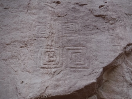
Square spiral petroglyphs in southern Utah. Photo by Gerald Trainor.

A unique set of four square spiral petroglyphs. Do they represent the seasons? I would be curious to revisit this site during the seasonal changes to see if there are any types of solar alignments.

One thing that struck me this trip beyond all else was the amount of time we spend planning, and where that planning can sometimes get us. Don’t get me wrong- planning can be everything, it can mean the difference between a fun, memorable trip and a disaster. But there are times that planning can get in the way of our adventures. Planning can hold us back, it can hold back the explorer in us and stifle the sense of accomplishment, the sense of discovery that we seek out there in the bush.

We live in an overstimulated world with just too much information flowing around us, in our heads and readily at hand. One of the reasons I go into the desert is to escape all that. And I don’t want to bring along a bunch of data- on anything. I want to walk and see and hear things, feel the sand under my boots or under my bare feet, wonder about what is around the next corner.  I don’t want to look for the next thing I am supposed to find at a certain distance from a certain point. Where is the fun in that? For me, that is too much like everything else in life these days- click a link and it’s all there. That is decidedly not what wilderness is about for me.
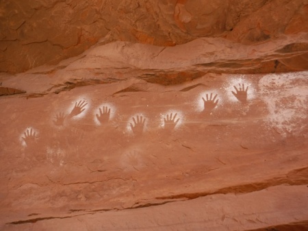
white hand pictographs in San Juan county, Utah. Photo by Gerald Trainor.

White hands- one of my favorite pictographs, and one of the first I “discovered” in southeast Utah about 20 years ago. I visited them again on this trip.

I have never been one to plan an entire trip, hour by hour, water point to water point, camp site to camp site. I know that people do this. There are guide books that do it for you. This is one of the very reasons I don’t use guide books, other than for very general information. My favorite writer of guides, as I have expressed over the years, is Michael Kelsey. He gives clear, concise, to-the-point information, and not much more. That is all I want- mileage to the trailhead for example, if I don’t choose my own, or maybe data on the best way to climb out of a canyon that everyone says cannot be climbed out of. Kelsey’s books are the place for something like that. After that, it is all up to me.

Moving on from my philosophy of wilderness travel back to civilisation, I always end my trips in Moab. I like to mention my favorite local businesses, in support of the community there. Moab Gear Trader has recently moved into the space above their original store. They have so much used and new gear now that it’s easy to find something you can use. I have an account there, and usually drop gear to sell on every trip. You don’t have to live locally to do this- give them a call to see if they may want your used gear. And if you can’t find what you need there, just down the street is Gearheads, where you will find whatever it is you forgot to bring along. There was a time when I would worry about that piece of gear that I inadvertently left behind, but not any more. Between Moab Gear Trader and Gearheads, I know I will find what I need.
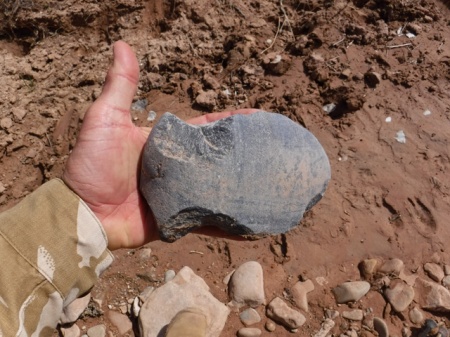
Axe head found in wash in southeast Utah. Photo by Gerald Trainor.

Found in a wash bottom- one large axe head. They artifact had signs that it had been in the wash for some time, and also plenty of use wear. It was made from a perfectly shaped, very flat river cobble.

Gear is good, but we can’t leave out food and coffee to make us happy. Moonflower Coop, on 100 North right off of Main Street, recently completed a major renovation and it is not to be missed. They even  have a seating area now at their deli, where they offer fresh salads, sandwiches, soups, and much more. They are right across the street from Moab Coffee Roasters, one of our favorites. Need a backup bike tube with your coffee? Be sure to visit Moab Classic Bikes on Center Street for both- yes, there is a coffee shop in the bike store. Very convenient!

Our next trip is planned for the end of May- a couple of weeks in the Hanksville area. We are planning, if weather and water levels permit, to walk the Dirty Devil River. No dragging the boat this year! In the meantime, there is plenty more information on desert travels in southern Utah at DesertExplorer.us.


This Way Down, and An Update From Moab

20 March 2016

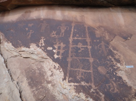
We have been spending a lot of time in Comb Ridge in recent years, stopping in for a few hikes on nearly every trip. We have been in many of the drainages along the southern end, starting at the highway. But there are many more summer’s worth of hikes towards the north. One specific goal this summer is to find at least one of the crossovers into Comb Wash from the Butler Wash side. I understand that there are a couple of them. And I have a suspicion that we may have been in one of the drainages that leads to the other side. A few summers back we here high up one of the canyons, walking up canyon, when we found a small petroglyph panel that had a large ladder-looking inscription. To me it looked just like a kiva ladder. Did the ladder signify to travelers that they could climb down the other side if the followed this particular drainage? This is a question I would like to answer, to see if this was an ancient signpost saying “this way down”.

Kia ladder petro. Image by Gerald Trainor.

Kiva ladder petroglyph from a canyon along Comb Ridge. Scale at right of image is 10 cm.

Update From Moab
We were in Moab in January when news broke about the closing of another missing person case. On the evening of 19 November, back in 2010, Ranger Brody Young was checking on a car parked at the Poison Spider trailhead. The person in the car opened fire on him, hitting him nine times. Range Brody returned fire and apparently hit the suspect as he fled. The suspect’s car was found within a few miles, but he was not found. A manhunt ensued, but was unsuccessful in locating the suspect. Now, five years later, the body of Lance Arellano has been located. A college student home for the Christmas holiday and his younger brother did a systematic search of the area where the suspect was last known to be, and found his remains.  The brothers will split the $30,000 reward. You can read more about the incident on the Moab Times website.

You can read my original blog post and subsequent updates at the Desert Explorer Blog. For more on the 1998 Four Corners Manhunt or all of our desert adventures, visit the Desert Explorer website.


Spring Break Trip Report- March 2014

6 April 2014

We have just returned from one if the most memorable Spring break trips in years. The trip included some of our usual endeavors- seeing rock art and ruins, a bit of gold panning, hiking along Comb Ridge, and plenty of exploring of dirt roads around southeastern Utah. It also included new adventures: a visit to Oljeto, on the Navajo reservation, to see the trading post where the Wetherills lived and then a drive down to the now defunct Piute Farms Marina at what was once part of Lake Powell.

Piute Farms waterfall. Photo by Gerald Trainor.

Piute Farms waterfall, about two miles below Clay Hills takeout, March 2014. The river below actually looked like a river. There were few signs that the lake had made it this far up the channel in years.

We also stopped in at Hite “Marina” (can you have a marina without water?) to take a look at the lake level on our way towards Hanksville. We drove down the boat ramp only to find that we could keep driving all the way across what used to be the lake right to the edge of the Colorado River. And it did look like a river- cutting down through the accumulated silt of the past 50 years and making its way toward the ocean. Looking down river, there was no lake in sight! Looking up river, the Dirty Devil was a muddy little stream braiding its way through the silt and into the Colorado. I can’t help but wonder how long it will take to clean out all that silt…. But more on that in a future blog.

Colorado River at Hite Marina. Photo by Gerald Trainor.

The Colorado River, at Hite Marina. Looking down river, as it makes its way to the ocean.

Silt plain that was once Lake Powell. Photo by Gerald Trainor.

I hope this adds a bit of perspective to what is going on at Hite Marina. This photo was taken at the edge of the river, where I stood when I took the top photo, looking back over the silty, tumbleweed-scattered plain that was once the bottom of Lake Powell. That is our Landcruiser in the middle distance, with the boat ramp far off in the photo.

Back to the archaeology for now. One of our early stops was just outside Blanding to look at a few rock art panels and nearby ruins. We met up with a group of archaeology students, their “tour” leader Daniel Cutrone, the Principle Investigator at the Nancy Patterson site in Montezuma Canyon and professor at California State University Dominguez Hills, and our friend Madalyn from the Edge of Cedars Museum in Blanding.

Nancy Patteson site. Photo by Gerald Trainor.

A central view of the Nancy Patterson site, showing excavated walls and many of the mounds that make up the possible 300 rooms of the site.

Daniel, Madalyn, and their crew kindly took us along on their outings to a few unnamed sites, the Nancy Patterson site, Spirit Bird Cave, and a behind-the-scenes tour of the Edge of Cedars Museum. We were joined on one of the days by Sally Cole, author of Legacy on Stone, among other titles. What a treat it was to look at rock art and not have to pull out our copy of her book for interpretation- all we had to do was listen! The best part for both Nicolai and I was when we were asked if we wanted to return in the summer to be part of the ongoing excavation of the Nancy Patterson site. I haven’t done any excavation in years, and definitely welcome the return to the dirt. For Nicolai, I think it is a dream come true. For more on the Nancy Patterson site, ongoing excavation, and field work possibilities, see the Shovelbums Website.

We spent a few days in Poison Spring canyon, as we often do, enjoying the sites there and some of the slot canyons accessible from the canyon bottom. Next we drove on to Green River town. In and around Green River we explored the abandoned U.S. Army Pershing missile launch complex. What an adventure that was!

Green River missile launch complex. Photo by Gerald Trainor.

The guard shack and associated buildings at one of the main parts of the Green River launch complex.

Abandoned around 1979, the buildings are in a serious state of decay, with doors falling off or missing, fences broken down from power poles falling on them- the power poles having been chopped down by looters stealing the copper wire strung between them! Ceilings had fallen in, windows were mostly broken out, and nearly everything that could be carried away had been. And the few things left on site were well smashed up and thrown into piles in corners. It was perfectly post-apocalyptic in look and feel, including a grey, overcast sky above us. While exploring I kept expecting to round a corner to find a growling pack of ferrell dogs, or maybe zombies, or at least a boy and his father resting as they made their way down The Road. Perhaps that was us?

Tent city concrete pads. Photo by Gerald Trainor.

The concrete pads, perfectly aligned and dressed right, at what is referred to as the “tent city” outside Green River.

Bunker near Green River, Utah. Photo by Gerald Trainor.

Nicolai next to the bunker at the weather missile launch pads.

Either way, let it be known that we never crossed a fence, or a building threshold, as it is still government property and clearly marked as of limits… in a couple of places at least (most of those signs appear to have been stolen.) If you go, be sure to view it from afar.  We spoke to a local deputy who warned us that theft and vandalism have ramped up recently and that they are watching the sites. I have only touched on this marvel of modern science, warfare, our military-industrial complex, and our cold war history. Volumes could be written about it- not by me however. But I do plan to write a full blog about the site, and the Pershing and weather monitoring missiles launched from it in the near future.

Missile launch pad near Green River, Utah. Photo by Gerald Trainor.

One of the main launch pads, with rolling building still in place. There are two other, identical pads, both without the building or even the rails that it rolls on.

For now, we are planning our summer fieldwork, a family backpacking and exploring trip, and a solo trip for me. The summer promises to be a full one- be sure to get out and enjoy it. And watch out for rattlesnakes, they are already out. For more about snakes, and our desert adventures, visit the Desert Explorer website.


The Utah Desert in November and Tracking Books

28 October 2013

As a person who actually enjoys 100 degree days, I tend to visit the Utah desert mostly in summer. But Nicolai and I are ready to try something new- we are planning a trip to Utah in early November, something I haven’t done in a long time. The days will be shorter, and the nights colder. But the stars will still be in the sky, tracks will still be on the ground, and the canyons will still be waiting for us. And to paraphrase that rather common fishing bumper sticker, “any day exploring the desert is better than a day….” You can fill the rest in.

An interesting petroglyph along the San Juan River. I have adjusted the contrast a bit to make it clearer. The actual patina is much lighter.

An interesting petroglyph along the San Juan River. I have adjusted the contrast a bit to make it clearer. The actual patina is much lighter and the glyph is covered by a light coating of sand carried by water running down the wall from high above.

Our plan is to head over the mountains on about the 7th of November and spend 10 or 12 days exploring. We will start in the Bluff area and continue walking the canyons of Comb Ridge, and investigating some of the new canyons we “discovered” on a recent trip. On the edge of one of those canyons we found a tremendous flake scatter, along with some incredible potsherds in many different styles. This will be our starting point for our exploration, with the goal of finding out if there are any other occupation areas in the canyon. If the weather allows we may do an overnight or two in the canyon. Otherwise there will be lots of day hikes and plenty of fires at the truck. We had hoped to fit in a visit to Kayenta, and then Navajo National Monument with a hike out to Keet Seel. But the park closes for hiking from early September through late May. So we’ll save that hike for next summer. Read more about Navajo National Monument, their season, and hiking there on the NPS website.

Beautiful potsherds at a site we have recently "discovered". The styles there were incredibly diverse.

Beautiful potsherds at a site we have recently “discovered”. The styles there were incredibly diverse.

I am also looking forward to finding some tracks- any tracks- and following them. Tracking is something that I find relaxing, challenging, soothing, and exciting at the same time. It is a primal urge that still lives in all of us, and for me it is important to let it out. And as I have noted in many past blogs, I feel it is an incredibly important skill for Nicolai to learn, for many reasons. We will take along a few of our tracking guides to study, being sure to re-read parts of them before we start out. Since we don’t have a teacher or mentor and are primarily using books to learn from,  it is important for us to revisit them as often as possible to make sure we haven’t forgotten too much. We have posted a list of all the tracking books we have in our library on the Desert Explorer website Tracking Pages, and continue to add to it as we find more titles.

A tracking book that we hope to add to the list soon, one I have been trying to find for years is The Art of Tracking: The Origin of Science by Louis Liebenberg. The link takes you to a free download of the book, which will be available in print in the very near future, by the end of October 2013 according to various internet sources. I will be ordering a printed copy if the rumor is true. Be sure to click through to the home page if you visit Liebenberg’s website- the site is quite interesting and there is a lot to it.

Anyone wishing to can follow our trip at our website, DesertExplorer.us– see the Twitter posts at the bottom of the page. These are automated and posted as we check in with our SPOT Messenger. We usually do a check in each night at camp, and also when we find a ruin or rock art panel.


Trip Report- Spring Break 2013 in Southeast Utah

15 April 2013

We have just returned from another exciting Spring break trip to southeast Utah. We made the usual rounds, from Cisco down to Bluff and Mexican Hat, across Cedar Mesa, back up through Hanksville to Price, and on to Green River and Moab for a day. The weather was varied as it always is this time of year- from freezing cold and strong winds, to sunny, warm, summer-like days. You just never know what you’ll get in Spring in southeast Utah and it is important to be prepared for everything from sitting out snowstorms in the tent for a few days, to having plenty of sunblock and your shorts and river sandals on hand.

Comb Ridge
One of the highlights of our trip included five days of camping near the San Juan River outside Bluff, and hiking there and in Comb Ridge. We also hiked along the river, including a look at the panels around Sand Island, and up some small side canyons right from camp. But most of our time was spent in the middle part of Comb Ridge.  We managed to see five of the canyons there with ruins and rock art around every corner. We did our best to hike up one canyon then down another, but as anyone who has been along Comb Ridge knows, there are plenty of pour offs to send you back the way you came or at least send you looking for another route.  The good thing about Comb Ridge is that the canyons are all short, and backtracking is never a big deal. Comb Ridge was a busy place, with lots of hikers and people camping at nearly every site along Butler Wash. Keep this in mind if you plan a visit over Spring break.

A kiva in one of the Comb Ridge canyons. Photo by Gerald Trainor.

A kiva in one of the Comb Ridge canyons.

Tracking Practice
We did take advantage of having to backtrack from a couple of the canyons, using it as a chance to work on our tracking skills and to see a different part of the lives of the ancient inhabitants along the canyon mouths- including ancient campsites, lithic scatters, and storage cysts. Some of the approaches were long for us (we didn’t drive to a different “trailhead” for each canyon, but worked our way along the ridge from one). The walks back along these routes allowed us to find our tracks coming in, examine them for changes based on the weather and other hikers, and follow them back to our start point.  Again, being Spring break, there were plenty of other hikers out- because of this we were forced to use the lost track drill a number of times, casting about for our tracks among others, and doing the same out on the flat where we made it a point to use anti-tracking measures on our way in. By anti-tracking, or counter-tracking, I mean simply trying to walk as carefully as possible so as to hide our tracks- walking close to brush in shadows, through heavy, well-traveled brush, and across slickrock patches wherever we could.  In doing so we benefited going out and coming back.

A grooved stone we found on our approach to one of the canyons. Scale is in centimeters.

A grooved stone we found on our approach to one of the canyons. Grooves are on both sides, running parallel. Pictured side is the more pronounced. Scale is in centimeters.

The Dirty Devil River
After our stay in the Comb Ridge area we headed west and spent a night near Hite on the rim of the Dirty Devil River canyon.  The river was flowing at about 150 CFS then, but the mud chutes at the end of the river and directly flowing into the Colorado at this point were not promising for a float. It looked like a muddy mess ready to capture anyone who stepped into it.  The lake was so low that the Dirty Devil actually flowed into the Colorado River, and together they flowed off into the distance, a thin stream of a river in the middle of a vast horizon of mud.

Dirty Devil River as it flows toward the Colorado at Hite Crossing.  Photo by Gerald Trainor.

Dirty Devil River as it flows toward the Colorado at Hite Crossing. A murky thread of water through dried mud.

We stopped for a day in the Irish Canyons in North Wash, and then spent a night at Angel Point and had a walk down to the Dirty Devil River the next day. The river looked much more floatable from this point, really looking like it was flowing at 150 CFS and without a sandbar snag in sight. We recently had some comments and questions on putting in there. Aside from the walk down to the river- across slickrock, rocky with exposure in a few places, and bushy in others, the river looked good. The party mentioned was using 5 pound pack rafts- we are still waiting to hear the outcome.

Nine Mile Canyon
Next was a visit to Price and the College of Eastern Utah Museum. The museum houses a collection of artifacts from the surrounding region highlighting, among other things, the Fremont culture.  There is also an impressive paleontology collection. If you visit Price, or even find yourself driving through, the museum can be found right in the center of town and is worth the stop. From Price it is just a 15 minute drive south to Wellington and the turn off into Nine Mile Canyon.

A well known pictograph in Nine Mile Canyon. You may have seen this one in National Geographic- the damaged happened long ago before the state intervened on behalf of history.

A well known pictograph in Nine Mile Canyon. You may have seen this one featured in National Geographic.  The damage happened long ago before the state intervened on behalf of the preservation of pre-history here.

The name of the canyon is deceiving, being some 70 miles long in total.  The road through the canyon has been recently paved, and is in perfect shape. The is a short section mid-way that remains unpaved, but any vehicle can make it all the way up to the Big Buffalo and Great Hunt petroglyph panels, some of the highlights of the canyon. We turned around there and backtracked, but you can continue north from about mile 37 to Myton. In my opinion, the canyon has more than can be seen in a long day, especially if you plan to do any of the hikes-there are countless rock art site, ruins, and many points of historic interest.  Note that camping is not allowed anywhere in the canyon, other than at the Nine Mile Ranch private campground. So plan accordingly and start your trip into the canyon early, allowing at least a full day.

Great Hunt panel in Nine Mile Canyon. Photo by Gerald Trainor.

One of the more well-known panels in Nine Mile Canyon- called the Great Hunt panel.

Gear Reviews
I always try to highlight a piece of gear in each blog, and for this post I have chosen Rite in the Rain notebooks and Fisher Pens.  It is hard to imagine one without the other. Rite in the Rain notebooks come in many different sizes and page formats, but I tend to use one of the originals- the 3 by 5 inch, spiral top notebook.  It fits easily into any pocket and with its plastic cover, it is virtually indestructible. But the key feature that makes Rite in the Rain products so important to someone who spends a lot of time outdoors is that the pages are waterproof.  I have swam with my notebooks, used them in monsoon rains where I have been soaked through, taken notes during archaeological fieldwork sessions in dripping Central American jungles, and used them for years while in the military. I cannot say enough about the quality and functionality of their products. You can see the spiral bound notebooks and Fisher pens at TwoHandsPaperie.com.

Rite in the Rain notebooks- photo by Gerald Trainor.

Rite in the Rain spiral notebooks- a collection from over the years, including one of Nicolai’s. Archaeological fieldwork, river trips, bikepacking trips, and backpacks are all recorded here.

Fisher pens are the perfect companion writing instrument for the waterproof notebooks. Fisher pen refills are pressurized, and will write upside down, in any temperature you might normally encounter, and on wet Rite in the Rain notebook pages. The Stowaway Pen with a clip is the perfect pen for the 3 by 5 spiral top notebook- the pen slides right into the spiral and clips into place. This pen is also about the most lightweight pen imaginable. The only thing lighter might be just a pen refill by itself! The refills last an incredibly long time as well, and perform perfectly in the desert, mountains, or jungle.

Rite in the Rain spiral notebook with Fisher pen, Photo by Gerald Trainor.

Rite in the Rain 3 by 5 inch spiral notebook with Fisher Stowaway pen securely fastened in spiral binding.

For more on our desert adventures, tracking, and rock art, visit the Desert Explorer website.


A Quick Post From Moab

23 May 2011

I am in Moab today, heading in the direction of home. I’ve spent nearly the last two weeks in the Escalante, down Moody Canyon to the Escalante River and points south and west of there. The backpack, although windy, cold, and rainy at times, was a complete success. I ended up walking a comfortable 100 miles in 8 days time. I will outline the details in a series of posts once I get back home in a few days. There is a lot to cover and it will take two or three posts to do it. Besides discussing the walk itself, I plan to review a few new pieces of equipment including the Golite Trinity Malpais jacket, OTB Desert Boots, and Rokit Fuel endurance foods that I tried out, and discuss some issues I had in the area once again (involving Leave No Trace policies).

A few quick points of note from Moab this afternoon:

  • On the way through Hanksville yesterday the Dirty Devil River from the bridge looked about as high as I have seen it. Lots of water flowing in Southern Utah right now. I am thinking about getting home as fast as I can and arranging a float trip right away.
  • While driving through Green River this morning I saw that the Green is very high as well, extremely high in fact. There are sand bags piled at the river’s edge at the hotel across from the J.W. Powell River History Museum. I drove down to Crystal Geyser and the water there is up to the geyser’s lower ledges of mineral deposits. Time to float the Green if you can get away to do it!
  • Here in Moab the new recreation center is open. I stopped in this morning and had a look. If it weren’t overcast, rainy, and breezy I would consider going for a swim. The place is truly a gem. Stop in and take a look next time you are in town.
  • Finally, Horsethief Road down to Mineral Bottom is open. Apparently it has been open since late March. Talk is that the drive down is much nicer than it used to be. Now the bad news- the river is currently so high that you might not be able to drive over to Mineral Bottom. I am told the water is up to and covering the road in places. Be sure to check in with the Park Service before finalising any upcoming trips.

That is it from Moab this afternoon. I am off to look at some rock art now. Check back in the next week or so for the first of my post-Escalante Trek posts.

Until then visit the Desert Explorer website for more information on the region.


Utah and Arizona- March 2011

21 April 2011

Nicolai and I left Colorado on 15 March and headed for our usual special camp just across the border in Utah. We expected- or at least hoped for- warm weather through the trip. We ended up with cool weather, some rain, some snow, and wind nearly every day. Knowing that this can happen in the early spring of the desert, we were prepared with plenty of winter clothing, our Sorrel boots, and goggles for the sand storms. And plenty of fire wood.

Poison Spring Canyon
We began our trip by spending 4 days down Poison Spring Canyon south of Hanksville. We tried our hand at gold panning, did some exploring up side canyons, drove down to the ford at the Dirty Devil, looked at some rock art, and made a tamarisk bow and willow arrows for Nicolai. Both of these materials worked well for his purposes. We rounded the arrow shafts the best we could and straightened them on the fire. Our next step will be to make a shaft straightener and get them really straight.

Nicolai trying out his tamarisk bow and willow arrow.

There was a lot of activity in the area while we were there. It seemed that quite a few groups were floating the river, or at least trying to, around that same time. As we understand it, some people opted out in the end, others pushed on, even while on the verge of hypothermia, and another group had to cache their equipment, hike out, and return to finish the float a couple of weeks later. We are looking forward to hearing more about everyone’s trips.

Shield figures fighting, Poison Spring canyon, petroglyph

Shield figures fighting, Poison Spring canyon.

A Drive Down to Arizona- Canyon de Chelly
After our time in the Hanksville area we headed south towards Arizona. We made our usual stops around Moki Dugway for a night, and in Mexican Hat at the San Juan Inn for breakfast. Next we visited Chinle and Canyon de Chelly. This is an amazing canyon, full of history and prehistory, being occupied for over 5000 years. The canyon was the final stronghold of the Diné people against forced relocation by Kit Carson and his troops in 1864. This was known as “the Long Walk” to the Diné, as they were marched to Fort Sumner in New Mexico over 300 miles away.

Monument Valley off in the distance, on the drive south to Chinle.

The canyon is worth a visit even for a quick look if you are traveling through the area. There are driving tours on both the north and south sides of the canyon with viewing overlooks into the canyon along the way. There is only one location where you an enter the canyon without a guide, and that is to see the White House ruin. You can visit other places in the canyon by hiking or driving, even backpack there, but a guide must accompany you on the trip. Guides can be found in Chinle, and complete information can be found at the Canyon de Chelly visitor’s center.

The Hubbell Trading Post
Our drive took us on towards Ganado and the Hubbell Trading Post, where we spent and afternoon, an inadequate amount of time for a place so rich in history. While nothing can make up for the Long Walk and forced relocation, John Lorenzo Hubbell did more to help the Diné than anyone in his day. He is largely responsible for making the Navajo weaver known to the world. He helped create the craft at least in a commercial sense through the design and marketing of the “Ganado Red” rug, the quintessential style of Navajo textile.

Hubbell was a friend to the Navajo and to the artist as well. His house is full of drawings, paintings, weavings, baskets, and collections of art bought by him and given to him by many a famous artist. You can tour the house, and will find it in exactly the state lived in by the Hubbell family- it was sold to the Park Service by the Hubbell family in the 1960’s as is. Some clothes were packed up, the door was locked- this is how you will find it. The trading post itself is still in operation. You can buy supplies there, as well as contemporary weavings, baskets and other works of art. I have to mention that Teddy Roosevelt visited the place, and we saw the room and very bed where he slept- Nicolai was fascinated by this, as he is a big fan of Roosevelt.

Window Rock and the Navajo Nation Museum
We stayed the night in the Navajo Nation capital, Window Rock. There we visited the arch which gives the town its name, saw the veteran’s memorial and Code Talker memorial under Window Rock, stopped by KTNN, the nation’s radio station, for stickers, and toured the Navajo Nation museum. The museum is not to be glossed over. It is in new, modern structure whose form is after the hogan, the traditional Navajo dwelling, and of course it is entered from the east, as the hogan is.  The museum houses displays of contemporary Navajo art, historic and prehistoric artifacts, and a number of weavings of the “chief’s blanket” style that shouldn’t be missed. The museum is another “must see” if you are in the area.

Navajo Code Talker memorial, Window Rock, Arizona.

Navajo Code Talker memorial, Window Rock, Arizona.

Exped SynMat 7 Sleeping Pad
After Window Rock we headed back north for some camping and exploring in Cross Canyon, near Hovenweep National Monument, and further north around Blanding and Monticello and then to Moab. As we didn’t plan much in the way of backpacking for this trip, knowing it would be more of a road trip with plenty of tent nights, I finally took the plunge and invested in a new sleeping pad.

Eped SynMat 7

The Eped SynMat 7

The SynMat 7 by Exped is one of my favorite new pieces of gear in years. It has an integral pump that is operated by placing your hands over valves in the pump. I opted for the size medium-72 inch long, 20 inch wide, synthetic version. It comes in a down-filled version- the SynMat 9 Deluxe, giving a higher R value, and both are avail able in various widths and lengths. The SynMat 7 can be inflated in a couple of minutes without much effort. I had some of the best sleep I’ve had on the ground with this pad, and while it is not something I would carry in my backpack due to the weight (just under 2 pounds) and size, I will not sleep on anything else if I am at my truck or on a river trip. If you are in the market for a new pad make sure you take a look at this one.

For more gear recommendations and reviews, visit the Desert Explorer Gear Shop pages.

I am off to the Escalante in just under 3 weeks. I will be in the bush for 12 days or so, on a solo from Moody Canyon down to Coyote Gulch and back out. Check back for a trip report towards the end of May.

In the meantime, for more on our adventures, the Dirty Devil, primitive skills, and recommended gear, visit the Desert Explorer website.


Trip Report- Swell Rock Art, Grand Gulch, and Johns Canyon

12 October 2010

We are back in Colorado after two and a half perfect weeks in southeast Utah. You never know what to expect at the end of September, but we had great weather with unseasonably warm days and nights. The skies were clear,  filled with stars, planets, and a full moon. Temperatures were a warm 85 to 90 or so during the day, dropping to around 50 to 55 at night.

Rock Art and Green River Town
We began our trip by visiting a few rock art panels in the San Rafael Swell area. All the panels are named, quite well known, and are found on most maps. The Head of Sinbad panel, the Lone Warrior panel, and the Black Dragon panel are all rather easy to find and get to, provided you have a four wheel drive, or are prepared for a little walking. All three panels consist of pictographs, with petroglyphs also found at the Black Dragon panel.


Head of Sinbad panel, San Rafael Swell. The detail in this panel is really amazing, the lines are very fine and crisp.


The Lone Warrior panel is as the name implies, a single, isolated image. The pictograph is exposed to sun and the elements and as a result is not as clear as the Sinbad panel.


Along the way we stopped at the town of Green River where they were having their annual Melon Festival. The honeydew, cantaloupe, and watermelon were at their peak of ripeness and sweet and juicy. We also made a visit to Crystal Geyser and spent an afternoon there, alternating between walking through the cold water erupting from the geyser, and then dips into the warmer water of the Green River. There is a new coffee shop in town, right at the corner of Broadway and 150 West- it is a few doors away from the Melon Vine grocery store.  They serve Illy coffee- stop in and support them. See our Desert Links page for more on Green River.

After we left the Green River area we did our usual drive south towards Cedar Mesa with stops in Moab, along the edge of Canyonlands, and in Blanding. Matrimony Spring in Moab is still running strong, and there was nothing in the paper and no talk around town about closing it down again.

Horsethief Road
One important piece of news out of the Moab area had to do with a torrential downpour some time in August. The storm literally washed away the switchbacks on Horsethief road coming up from Mineral Bottom. The road is impassable by any vehicle (even a Toyota Land Cruiser.) It can be walked, and I could portage a mountain bike up through the washed out spots, and get a good workout doing it. According to the Grand Junction Sentinel, the damage is going to cost Grand County about 2.5 million dollars to fix, and it will take about 6 months to do so. The estimated loss in revenue is about 5 million dollars! So if you are still planning a river trip with a takeout at Mineral Bottom, or a ride of the White Rim, you will want to review your plans. See the National Park Service website for more info and great photos.

Cedar Mesa and Grand Gulch
We did a couple of overnight backpacks in Grand Gulch and its tributaries. On our first overnight we walked in on Government Trail and Nicolai finally got to see Big Man Panel, something he was very excited to do. Our next overnight took us down an unnamed canyon at the lower end of Cedar Mesa known locally as Lookout Canyon. This walk is not for the faint of heart or those that are out of shape, especially when it comes to exiting up the left drainage if you do the loop. Be sure to see our Lookout Canyon Dayhike page at the Desert Explorer website for more details on this hike. The hike is certainly worth it if you are up for it. Nicolai enjoyed the solitude, and we entered the canyon the night after a huge downpour, so we were negotiating not only downclimbs, house-sized boulders, pouroffs, and brush, but also pools and potholes filled with fresh rainwater. Red spotted toads were out in force after the rains. It was a great adventure, especially for a 6-year old.


Nicolai sketching the Big Man.


Johns Canyon Bikepacking Trip
Next we drove into Johns Canyon as far as is possible with a full-sized vehicle (Johns is spelled with no apostrophe, this is not a typo). After crossing over the drainage in the canyon bottom and heading south out of the canyon, there is a washout that apparently will not be repaired as it has been there for a number of years now and is just getting worse. It stops vehicle travel altogether, although dirt bikes and possibly ATV’s can get past. From this point we got on our bikes and rode most of a day to an even rougher section of what was once the road to the mouth of Slickhorn Canyon. Nicolai made the decision at this point that we should turn back and camp at a nearby switchback. It was a perfect campsite, allowing us to watch the sun set, then Venus, and Jupiter rise in the east.


Petroglyph in Johns Canyon- man with headdress, over a meter high.


Along the way we saw a number of rock art panels. I am sure we missed a few as well. It seems that this road was also a route used by the ancient inhabitants of the area to reach the San Juan River at the mouth of Slickhorn Canyon. If you do this ride, and plan to go all the way to the river, I recommend not hauling a trailer as we did. Panniers would make the portages through the washouts much easier. Be sure to carry a patch kit and extra tubes!

Unschooling in Southeast Utah
Adventures such as these are a large part of our unschooling experience. Nicolai does not attend school; his learning is largely based on what we decide to do on any given day, and on our travels and adventures, wherever they may take place. Learning for us occurs on many levels, but it is always occurring. For example while on this trip we studied not only the rock art of the basketmaker and Puebloan cultures who inhabited the area, but many other aspects of their cultures such as their technology, farming practices, building methods, food storage and preparation, and hunting strategies.

On our trips we always pay attention to astronomy- the planets and their appearance and disappearance, moon phases, and stellar navigation. On this trip we talked about how our view of the stars and planets differ between the northern and southern hemispheres. We always focus on geology while in Utah- discussing geology there is as necessary as breathing. Utah is a living geology textbook. We incorporate engineering and math into our discussions of ancient cultures, as well as the spiritual aspects of their lives. We discuss military tactics and strategies on our trips as well- Puebloan cultures and their choices for habitation lend well to this topic.  And of course there is the flora and fauna of Utah and our ongoing study of primitive skills. The point here is that learning is not something we do at a desk, and never will be. Learning comes with our daily experiences and we take advantage of every one of them to grow and learn and expand our horizons. For more of our thoughts on unschooling and nature, visit the Desert Explorer Wilderness Kids pages.

Next on the agenda: a trip to the Colorado Canyons. It has been years since I have visited the area, and I have been trying to get back there ever since. A few days exploring Jones Canyon from its mouth is in the works for early November. Check back for more on that trip. See our Colorado Canyons pages for more information on the area.


Photos Posted, Planning, and Dirty Devil Updates

6 May 2010

We have posted a selection of photos from our recent trip to Utah. These are posted on Picasa.  We have tried Flickr and Picasa recently, and Picasa seems to be the better of the two. Most of the photos are just snapshots, but capture the feel of the desert. We usually carry only a small digital point and shoot, an older Sony Cybershot. The camera is small, fits in my pocket, and weighs little. For what it is, it takes great photos and has held up very well through river floats, sand and rain storms, countless miles in canyon bottoms, being beaten on canyon walls while climbing, and more drenchings than it should have survived. The latest version must be up to around 10 or 12 megapixels. I am sure it can be found at Amazon.com or at B and H Photo.

We are currently in the process of doing truck maintenance and planning and packing for our next trip.  We will leave the first of June for some exploration of the area north of Arches National Park- we have heard there are dinosaur bones and tracks visible in that area. From there we are planning 4 or 5 days of backpacking in Grand Gulch, then we’ll head south to Kayenta for mutton stew and Navajo National Monument to see ruins there.

For those floating the Dirty Devil, many people have been posting on our original Dirty Devil trip report blog post.  There is information there from recent floats for those planning on floating soon. Every time I get a comment I start thinking about floating it again. You may see a planning post for it here soon, with some luck. The river is flowing at about 30 CFS this morning for those interested.

For more on visiting southeast Utah, visit the Desert Explorer website.


Planning For the Next Utah Trip- Hiking, Hafting, and Hunting

23 January 2010

Normally this time of year finds me working away  at reviewing the past season, posting blogs, photos, info, and adding new web pages to the Desert Explorer website. The cold of the winter usually keeps me indoors, and thus affords the time for writing and planning for the coming summer. But this winter proves to be quite busy- with the holidays, new business ventures, and a notebook full of things to do, my time has been taken up elsewhere. My apologies to those looking for new info from Desert Explorer.

The Next Trip
Nicolai and I had planned to take a trip to Utah before Christmas, focusing on Horseshoe Canyon and a few other points of interest around Hanksville. But the cold put us off. My five-year old is quite tough, but the constant low temperatures and snow forecast for the area made both of us think twice about 8 or 10 days out in the bush at this time of year. At this point we have re-scheduled our trip for mid-March, once the temperatures start to rise and the days are longer.  We are both really looking forward to the trip as we always are; Nicolai now brings up ‘going to Utah’ as much as I do.

As for our itinerary, we  are planning a couple of hikes in Horseshoe Canyon, with an overnight up a side canyon (camping is not allowed in the Horseshoe Canyon unit of Canyonlands). We are also planning a recon of trailheads and entrances into a couple of canyons in the San Rafael Swell and a look at the river for a future float, some hiking in Robbers Roost Canyon,  a day or two of canyoneering in North Wash, and some time looking at the geology of the region.

The area around Hanksville has some very interesting geologic features. First there is the Factory Butte area with its mesas of Mancos shale capped with sandstone.  Near Factory Butte, on the road to Hanksville, you can see fossilised oysters in the exposed Mancos shale and Dakota sandstone. There is Goblin Valley to the north- Entrada sandstone eroded into animal, human, and various other sculpted forms.  There are the igneous lacoliths that make up the Henry Mountains. And there is the Dirty Devil River canyon and its tributaries, starting in the Entrada formation and emerging at Hite in the Moenkopi formation. If you are interested in the geology of the region, one of our favorite books  is Halka Chronic’s Roadside Geology of Utah.

Rabbit Hunting and Primitive Weapons
Nicolai is very excited about the prospect of hunting rabbits on this trip. He has been practicing his tracking and stalking techniques on the countless squirrels, and the few cottontails, that inhabit our neighborhood. He has been talking about shooting a rabbit and eating it for months now. He plans to eat all the meat, the marrow (which he already does with chicken bones), keep some of the bones for tools, and keep the hide to make a bag for his tools. I am not averse to killing and eating a rabbit, although I can honestly say I haven’t done it in many years. I am not sure if we will use our primitive weapons for the task (I am not even sure it is allowed in Utah). Most likely we’ll take a long a rifle. Either way I think it is an important task for him, something I remember doing when I was his age. It will help further his understanding of the power of a rifle and its uses, the concept that we use all we can of an animal if we kill it, and even death itself and our responsibility  for the life of an animal. I think these are all concepts that are overlooked by most people, and are too far from the lives of most children these days where meat comes from the supermarket.

We have finally finished hafting an obsidian blade on a handle and a point on an arrow shaft.  I collected chunks of hardened pine pitch recently on a couple of mountain runs, and we melted it down in a can in our fire pit. We then painted the sinew holding the point and blade with the liquid pitch and dusted it with clean, dry, white ash from the fire. The white ash causes a  reaction when it contacts the warm pitch and creates an epoxy-like bond. Whether or not we use the tools on our trip, Nicolai now has them in his tool kit.

For more information on primitive weapons and skills, Utah trip guides, and desert hiking and backpacking, visit the Desert Explorer website.