End of Summer Reflection- Canyons, Rock Art, Backroads, and Walled Cities

21 November 2016

It seems that summer has finally ended. We had our first snow of the year in Boulder county last week, signaling the official end of warm weather. It is always a tough time of year when I change from shorts and Chacos into pants, boots, and jacket.  But it is also a time when I look back on the summer that has ended and reflect on all the new things I have seen and the adventures I have had. This year included more time at Nancy Patterson Village, lots of exploration in Montezuma Canyon, a couple of trips into Grand Gulch, and plenty of time in smaller canyons and on dirt roads across southern Utah. More exploration of Cottonwood Wash revealed many ruins, rock art panels, and a few sets of moki steps. One of my favorite “discoveries”, and it may be just that as I have been unable to find references to it, was a series of stone alignments pointing to Spirit Bird Cave. And as always, there was more climbing around in Comb Wash.

Besides indulging in the archaeology of Utah, we did a “side trip” this year and looked at some very different, and more extensive cultural history. Although it requires another post entirely, which may or may not happen, I’ll at least mention our few weeks in Europe in September, most of it in Croatia. In summary: Roman ruins, defensive positions from the time of the Romans, Venetians, Turks, World War II, and the Balkan war of the 1990’s. There was Split, Dubrovnik, Zagreb, and many cities in between, a week on the Adriatic Sea and visits to many islands including the Isle of Vis, which was a partisan stronghold during World War II and was covered with the history and archaeology of the period, not to mention its Cold War history.

Dubrovnik, Croatia- view from wall surrounding the city looking towards the Adriatic Sea.

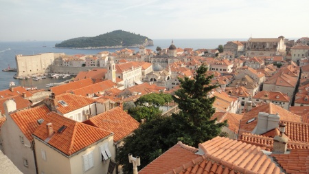
Dubrovnik, Croatia. Far from southern Utah, but an archaeological and historical dream. This view of the city’s rooftops is from the wall surrounding the city looking towards the Adriatic Sea. Many of the roofs are new- a relative term in a city over 1000 years old- having been destroyed by shelling from the Yugoslav Army and Navy during the siege of the city in late 1991.

Stone Alignments
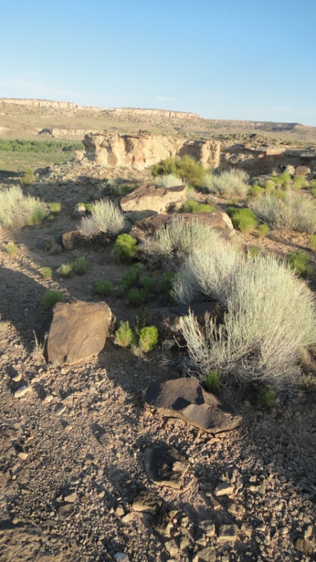
Back to Utah and its stone alignments. I do not recall having found anything quite like these stone alignments before, at least in this area of southern Utah. Of course that doesn’t mean they aren’t out there.  They reminded me of Mayan roads we often encountered while working in the jungles of Belize; wide, clear pathways with rocks piled along the margins leading off through the jungle. Inevitably the paths led directly to another ruin.  In this case, upon finding the first alignment, I suspected it had something to do with the nearby power lines and the access roads leading up to them. But then I found a corresponding alignment parallel to the first. To make it even more interesting, the next finger to the east had the same alignments, parallel to those on the first. And the third finger, still further east, had more aligned stones, albeit not as neatly done nor as complete as the first two sets. The first two sets had neatly cleared “alleyways” in between the stacked stones, where the stones were likely taken from.

Finally, standing in the center of the alignments looking west brought your eyes directly to Spirit Bird Cave on the rim across the canyon. Not a coincidence, to be sure. And not a “roadway” per se, but more of a ritual or spiritual roadway perhaps, if we accept the importance of Spirit Bird Cave within the context of the local ritual complex.

stone alignment near Sprit Bird Cave, southern Utah. Photo by Gerald Trainor

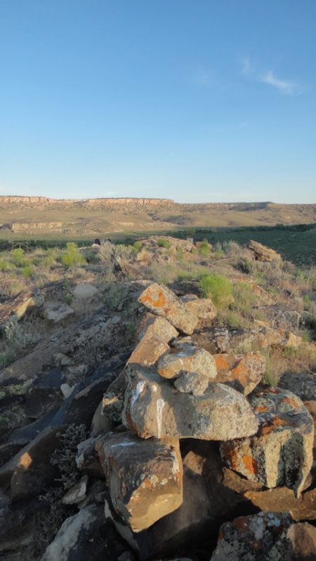
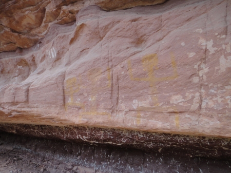
Stone alignment near Spirit Bird Cave, southern Utah. Spirit Bird is on the canyon rim off in the distance, directly in line with the stacked stones. Spirit Bird is slightly higher in elevation than the mesas the three alignments sit on.


Stone alignment near Nancy Patterson Village, southern Utah. Photo by Gerald trainor.

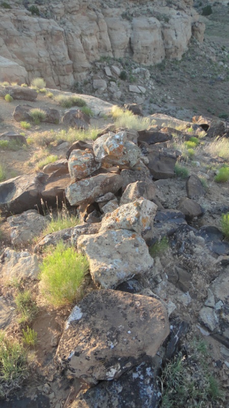
Same set of aligned stones, looking east toward the second finger of the mesa.


ritual pathways near Spirit Bird Cave, southern Utah. Photo by Gerald Trainor.

Alignment on the second finger, looking west towards the first finger and Spirit Bird Cave. The azimuth of the stones parallels those on the first finger and points directly to Spirit Bird Cave. This alignment had even larger stones than the alignments on the first finger, but not nearly as many stones in total.


Cottonwood Wash
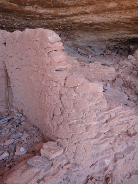
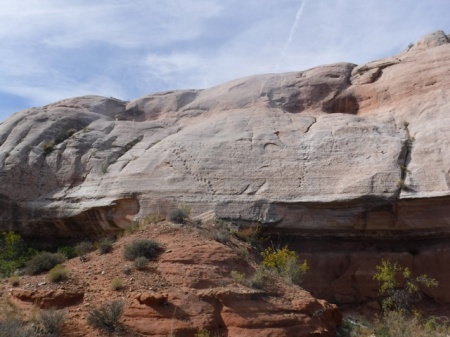
Cottonwood Wash is an extensive drainage covering more than forty miles from the Abajo Mountains until it meets the San Juan River in Bluff. The drainage is rich in many ways- plants, animals, birds, geology, and of course archaeology. Like Comb Ridge, Cottonwood Wash is a favorite “standby” hike for us. During my October trip I hiked the wash a couple of days at a couple of different locations and as always found more than I bargained for. A number of ruins had the most perfectly faced cut stones I have seen in some time. Not only was the facing perfectly flat and smooth, all the exposed stones in the walls were on exactly the same plane. I expected to find the level and string used in building the walls among the pot sherds.

Moki steps, southeast Utah. Photo by Gerald Trainor.

An array of moki steps. For some reason the ancient inhabitants created many ways out of the canyon at this location.

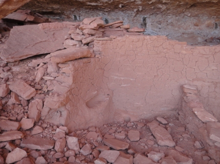
I also happened upon a very large cave with semi-subterranean structures. Unfortunately many of the structures had been dug out by looters, leaving the walls exposed. The cave also contained an array of hand prints- mostly yellow and green, but plenty of red as well.

Yellow hand prints, southern utah. Photo by Gerald Trainor.

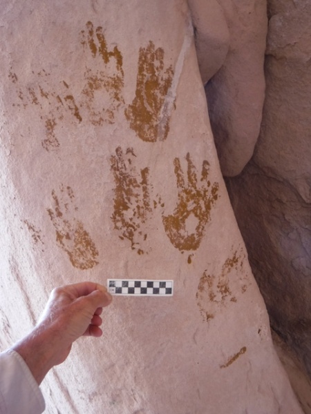
Some of the 200 hands in a large cave. Scale is 10 centimeters.


For more on our desert adventures, an introduction to the flora and fauna of Utah, and links to some of our favorite Utah-related books, visit the Desert Explorer website.


Another Spring Break in Canyon Country

21 April 2016

We have just returned from southern Utah once again. It was a late spring break for us, but well worth waiting for April to make the trip. The weather was perfect right up till the end, when we caught a bit of the storm that brought winter back to Colorado. We spent our two weeks in the usual places, revisited some of our favorite canyons, and explored some new ones. We made it a point to include plenty of time enjoying sunrises, sunsets, and the star filled night sky, and more than a few afternoons sitting on the slickrock with a cup of tea.

Blooming holly. Photo by Gerald Trainor.

Holly in bloom. The desert was alive with color and fragrance.

Our itinerary brought us straight to southern San Juan county this time. We made an afternoon stop in Moab for final supplies as always, but the weather was so perfect that Moab was too busy for us. April is the perfect time of year for most people- warm days and not too cool nights, without the extreme heat that comes in another month or so. Besides ATV’s and other off-road vehicles, there were mountain bikes everywhere, and more RV’s and camp trailers to be found around every corner than I have ever seen. This was the case everywhere we went- down every road whether it be along Comb Ridge, on Cedar Mesa, or around Green River, where we finished up our trip.

Grand Gulch
We did get a few days of backpacking in this trip. We walked in through Dripping Canyon, had a day in Grand Gulch, and walked out Step Canyon. This is something I have done before, so knew the walk quite well. It was perfect for Nicolai and I- nothing an 11-year-old couldn’t handle. As always, we could have used a couple more days in this short stretch of the canyons- there was just so much to see that we had to choose where to spend our time. For anyone venturing in any time soon, water was not a problem. At least finding drinking water that is. From another perspective, that of walking, it was quite a problem in places. There was so much water in the canyons that we found ourselves skirting pools all along the walk, and especially in Grand Gulch.

Yellow ancestral puebloan pictograph in Grand Gulch, Utah. Photo by Gerald Trainor.

“Yellow Man” panel in Grand Gulch.

Cedar Mesa was a busy place. The Kane Gulch ranger station was packed on the few occasions we stopped in. But once we got in the canyons we only saw, and heard, one group of people. I should say heard more than saw them. Their presence was known to us by their extremely loud voices, yelling I would call it, and their crashing wildly through the brush. We made it a point to discuss this problem with the folks at the ranger station after our walk- noise pollution is  a problem everywhere and especially in such a place as this. I feel that these days so many people don’t know the difference between a place that is… sacred, and say, the grocery store. The analogy I like to use is that I would not come bounding and crashing and yelling into your church, so please don’t come into mine that way. But I suppose, to continue the analogy, I am preaching to the choir here.

Comb Ridge
We have a favorite camp in view of Comb Ridge making it easy to get into the canyons there. We spent five nights on the slickrock at that camp, really enjoying the night sky. I have to make a plug here for one of my more recent equipment purchases. I have been sleeping better than ever these days on an Exped SynMat 7 Sleeping Pad. This inflatable sleeping pad has an integral pump which inflates it in just a couple of minutes. No blowing it up by mouth involved! I have the synthetic fill version which is rated at an insulation value of 4.9, but there is a higher rated pad that has down filling.  I use it at the truck and on the river- it’s just too heavy for me to carry on a backpack. The pads are not cheap, but if you are struggling with getting a good night’s sleep on a thinner pad, you may want to give one a try.

We spent a couple of days exploring Comb Ridge, and as always found more ruins and rock art, middens and moki steps, sweat lodges and seasonal campsites. Comb Ridge is truly a place where one can learn about the varied archaeology of the Northern San Juan region all in one place. One ruin we visited stood out in the amount of mud that was plastered on the walls. The ruin lacked for stone, but still held together well with mud. Looking at it you could see the way it was applied, in great masses, each appearing to be left to sag and dry before the next mass was applied. The interior of the walls had niches built-in, and the end walls were curiously rounded, as if they were not continued across the front, but were left open.

Ancestral Puebloan structure in Comb Ridge, Utah. Photo by Gerald Trainor

Comb Ridge ruin with walls lacking in stone but showing an abundance of mud.

Ancestral Puebloan dwelling in Comb Ridge, Utah. Photo by Gerald Trainor.

End wall of plastered ruin showing rounded finish. Note the thick mortar beds between the thin pieces of sandstone.

There is always so much to see, and to write about afterwards, on our Utah trips. But for now it’s back to preparation for the next trip. In about a month we are back in southern Utah for more archaeology at Nancy Patterson Village. For more about us and our desert adventures visit the Desert Explorer website.


This Way Down, and An Update From Moab

20 March 2016

We have been spending a lot of time in Comb Ridge in recent years, stopping in for a few hikes on nearly every trip. We have been in many of the drainages along the southern end, starting at the highway. But there are many more summer’s worth of hikes towards the north. One specific goal this summer is to find at least one of the crossovers into Comb Wash from the Butler Wash side. I understand that there are a couple of them. And I have a suspicion that we may have been in one of the drainages that leads to the other side. A few summers back we here high up one of the canyons, walking up canyon, when we found a small petroglyph panel that had a large ladder-looking inscription. To me it looked just like a kiva ladder. Did the ladder signify to travelers that they could climb down the other side if the followed this particular drainage? This is a question I would like to answer, to see if this was an ancient signpost saying “this way down”.

Kia ladder petro. Image by Gerald Trainor.

Kiva ladder petroglyph from a canyon along Comb Ridge. Scale at right of image is 10 cm.

Update From Moab
We were in Moab in January when news broke about the closing of another missing person case. On the evening of 19 November, back in 2010, Ranger Brody Young was checking on a car parked at the Poison Spider trailhead. The person in the car opened fire on him, hitting him nine times. Range Brody returned fire and apparently hit the suspect as he fled. The suspect’s car was found within a few miles, but he was not found. A manhunt ensued, but was unsuccessful in locating the suspect. Now, five years later, the body of Lance Arellano has been located. A college student home for the Christmas holiday and his younger brother did a systematic search of the area where the suspect was last known to be, and found his remains.  The brothers will split the $30,000 reward. You can read more about the incident on the Moab Times website.

You can read my original blog post and subsequent updates at the Desert Explorer Blog. For more on the 1998 Four Corners Manhunt or all of our desert adventures, visit the Desert Explorer website.