This Way Down, and An Update From Moab

20 March 2016

We have been spending a lot of time in Comb Ridge in recent years, stopping in for a few hikes on nearly every trip. We have been in many of the drainages along the southern end, starting at the highway. But there are many more summer’s worth of hikes towards the north. One specific goal this summer is to find at least one of the crossovers into Comb Wash from the Butler Wash side. I understand that there are a couple of them. And I have a suspicion that we may have been in one of the drainages that leads to the other side. A few summers back we here high up one of the canyons, walking up canyon, when we found a small petroglyph panel that had a large ladder-looking inscription. To me it looked just like a kiva ladder. Did the ladder signify to travelers that they could climb down the other side if the followed this particular drainage? This is a question I would like to answer, to see if this was an ancient signpost saying “this way down”.

Kia ladder petro. Image by Gerald Trainor.

Kiva ladder petroglyph from a canyon along Comb Ridge. Scale at right of image is 10 cm.

Update From Moab
We were in Moab in January when news broke about the closing of another missing person case. On the evening of 19 November, back in 2010, Ranger Brody Young was checking on a car parked at the Poison Spider trailhead. The person in the car opened fire on him, hitting him nine times. Range Brody returned fire and apparently hit the suspect as he fled. The suspect’s car was found within a few miles, but he was not found. A manhunt ensued, but was unsuccessful in locating the suspect. Now, five years later, the body of Lance Arellano has been located. A college student home for the Christmas holiday and his younger brother did a systematic search of the area where the suspect was last known to be, and found his remains.  The brothers will split the $30,000 reward. You can read more about the incident on the Moab Times website.

You can read my original blog post and subsequent updates at the Desert Explorer Blog. For more on the 1998 Four Corners Manhunt or all of our desert adventures, visit the Desert Explorer website.


Nancy Patterson Report, 2014- Long Overdue

25 October 2015

Let me apologise in advance to anyone who has been waiting to read more about archaeology at Nancy Patterson Village. But as I have noted in other posts, life in the physical realm takes precedence over “life” in cyberspace. This is becoming more and more the reality for me, which I feel is perfectly fine. No philosophical arguments will follow that statement. Instead, on to the archaeology. What follows is our report of fieldwork for the summer of 2014. There were no earth shattering discoveries. However there were plenty of exciting moments- the “ghost impression” of a metate that had been plastered in a floor and since removed, turkey egg shells, plenty of secondary refuse as fill between floors, and an interesting range of post-occupational stratigraphy inside the unit.

Below are the introduction and background of the paper. Click the link at the bottom of this page to open the full PDF of the paper. Permission to quote the paper is hereby granted so long as the work is properly cited. Finally, I apologise for the quality of a couple of the scans in the paper. I will try to update them with higher resolution scans.

Introduction

This paper will report on the findings and preliminary results of excavations of Unit R1 at Nancy Patterson Village, 42SA2110. Excavation and examination of artifacts took place over the course of 11 days, from 28 June through 08 July, 2014. Excavation was undertaken by Gerald Trainor and Nicolai Trainor, acting under Daniel Cutrone, project director of the Nancy Patterson Archaeological Project. Excavation focused on a single room in the southeast corner of the lower, floodplain pueblo of the site (Figure 1). Excavation began as a 1 by 1 meter unit on the interior of the room and was placed based on the exposure of the northwest, inside corner of two interior walls running east and south from this point. The unit was ultimately expanded to a 1 meter by 1.6 meter unit once the north-south trending wall was traced towards the adjacent plaza, and its adjoining east-west trending wall was discovered.

Background

Nancy Patterson Village is a large, multicomponent, temporally dynamic site spanning Basketmaker III through Pueblo III (AD 700- 1250) (Janetski and Hurst 1984; Wilde and Thompson 1988). The site is located at the confluence of Montezuma and Cross Canyons in San Juan County, Utah (Figure 2). Its location gave it not only access to water that flowed through the canyons and the wide canyon bottom floodplain for farming, but also potential control of traffic up and down Montezuma Canyon and eastward up Cross Canyon towards Hovenweep. The site consists of the commanding, mesa top component with its large viewshed and the floodplain component below and to the south. Views up and down Montezuma Canyon take in other dwelling sites, shrine sites, and petroglyph panels. The mesa top site was given the site identifier of 42SA2110 which is now used to refer to the entire Nancy Patterson Village, including the floodplain site.

The site is mentioned in early literature by Prudden (1903) during his exploration of the San Juan watershed. There are also references to Montezuma Canyon and its abundance of ruins by Cummings (1910), and other early archaeologists. Since that time investigation of the site has been undertaken by various archaeologists and students from Brigham Young University, and more recently by Cutrone and his students along with help from Blanding residents. The land on which Nancy Patterson Village sits is privately held and, being now more closely controlled, it is hoped also protected from further vandalism, looting, and damage.

NPROOM1_JULY2014_w_scans


Trip Report- August Family Trip and San Juan Float

22 September 2014

We took about two and a half weeks in August for our yearly, family desert adventure which included 6 days for yet another leisurely float of the San Juan River. This seems to be our most common family adventure, occurring almost every year, and it never gets old. As usual it was challenging at times (wind, rain, not enough ice!), and of course completely relaxing. Any time in the bush, away from the craziness of the world is good.

Panoramic view to the south of "train camp", one of our frequently visited camps in Utah. It has a great view of Westwater, the La Sals, and the railroad tracks.

Panoramic view to the south from “train camp”, one of our frequently visited camps in Utah. It has a great view of Westwater, the La Sals, and the railroad tracks from the cliff edge.

We made our way casually down to Bluff and the put in, beginning with a day in Green River for lunch from the taco truck, melons, and a look at a part of the abandoned Pershing Missile Launch Complex that we had not visited. Mia had not seen it at all, so it was an exciting experience for her, seeing a part of our Cold War history in person. Not to mention her first rattlesnake. We were at the radar site, taking a look in the lunch room, admiring the pink porcelain stove that was still sitting there. Right next to the stove, coiled and resting on a piece of fallen drywall, sat a small snake taking advantage of the cool lunch room. It didn’t even move; we stayed far enough from it so as not to disturb its rest, and backed out the door. They can be anywhere, so be careful crawling around in desert canyons and abandoned lunch rooms.

Green River Pershing Missile Launch Complex. Photo by Gerald Trainor

Inside view of one of the abandoned radar station buildings at the launch complex.

Once we reached the river it was the usual packing frenzy to get on the river as early as possible. It must look funny to people who stumble upon river runners packing, with gear strewn in seemingly random piles, half-filled dry bags lying about, and boat parts, paddles, and PFD’s hanging off the truck. But there is a method, and it all fits in its place perfectly in the end. I am always amazed at how much gear can go into a dry bag, and how much we take along in our little boats.

Aire duckies ready to go on the San Juan river. Photo by Gerald Trainor

Our duckies, and Mia and Nico, ready for the 6 day trip. It’s amazing how much they hold and how stable they are.

I won’t say much about the float, other than it was perfect. The weather was mild for the most part, the river was low, and therefore quite clean, until the last day. On our last night there were storms off to the southeast and we woke to a river that had risen about 2500 CFS, making the last day was a quick float down to Mexican Hat. Along the way we visited some of the usual sites, trying to alternate as there are so many, and trying to add new stops to our itinerary as well. Butler Wash, River House, and Baseball Man were a few of the stops. There was much sitting around, enjoying cups of tea, the sound of the river, the play of light on the canyon walls as the sun moved across the sky. As usual we took along a trip book- a set of blank pages, mostly Mohawk, but some Arches and  Stonehenge (paper brands) for writing, drawing, painting, and gluing. On all of our trips we create a visual  and written journal, adding scraps of paper to it- receipts, food wrappers, permits, and eventually photos from the trip. Once we are home we bind them and they go on a special shelf full of books of our adventures.

Baseball Man panel, Utah. Photo by Gerald Trainor

Baseball Man panel, one of our favorite hikes from the river.

After the float we had a goal (unmet) of finding roast mutton and frybread. We drove south to Monument Valley, hoping to find a roadside vendor, but were out of luck. We traveled on to Kayenta and searched there, but again without success. Down in the Shiprock area it’s easy to find, but not so in the Monument Valley area. We settled for Mexican food at the Amigo Cafe, a good choice. We stayed in Kayenta for the night to clean up after the trip and prepare for the next week of travel. The Wetherill Inn is our favorite motel in Kayenta, always clean, quiet, and offering a good night’s rest.

Before leaving we took Mia to the Code Talker exhibit at the Burger King, and visited the Shade House Museum next door. Nicolai and I have visited there a few times, but Mia had never seen it. The Burger King has a few well-presented cases full of donated items brought back from the Pacific theater, and the Shade House has even more. The Shade House has the PBS documentary on the Code Talkers playing continuously- if you have the time sit and watch it. It is an amazing piece of history, very informative, and something that everyone should know about. The Shade House also displays and explains a bit about the history and life of the Navajo people, not just about their WWII service.

After Kayenta, we headed north again with time in Montezuma Canyon and the Nancy Patterson site, and a drive through Lisbon Valley. A few days in Moab, and two days in Grand Junction ended our trip. For more on our desert adventures visit the Desert Explorer website.


Trip Report- July, 2014- Excavation at Nancy Patterson Village

5 August 2014

Nicolai and I spent another two weeks in some of our favorite places in southeast Utah in late June and early July. The weather was normal for this time of year- hot, dry, and windy. There was no rain to speak of, and likely none coming for a while. We made it to the San Juan River on a few afternoons for a swim, and also to the Blanding pool a couple of times. We spent the Fourth of July in Blanding, enjoyed the great selection of food at their celebration, and the fireworks later that night. I have to mention that we had the best Fourth of July food there- roast mutton and fry bread, Navajo tacos, and chil chin (in Navajo), or red berry soup. That was a treat! We hiked a couple of days, as we had time, along the San Juan and in Comb Ridge, and camped at a few of our favorite spots. Favorite spots are easy to find in southeast Utah (they are just about anywhere we go.)

Collared lizard. Photo by Gerald Trainor.

Collared lizard that was very curious about our excavation. There were many of them out and about this summer.

Nancy Patterson Village
The highlight of our trip was the archaeology of Nancy Patterson Village. We spent 10 days focused on excavation at the site, examination of the artifacts, and formulating a draft report. We will post a separate blog on the excavation as the report comes together, but we give a brief account here. Nancy Patterson Village is a Pueblo III (AD 1100- 1250) with underlying P II (AD 900-1100) habitation. It is located in Montezuma Canyon and at its height had some 300 rooms with as many as 30 associated kivas. There are two distinct parts to the site- the upper, mesa-top ruins and the lower, flood plain ruins.  Culturally it is related to nearby Mesa Verde.

Nicolai in our excavation unit- Nancy Patteson Village. Photo by Gerald Trainor.

Nicolai the archaeologist in our unit- living the dream of the 9-year-old.

The goal of the current excavation at Nancy Patterson Village is the definition of architecture on the outside edge of the lower, flood plain settlement area. This area is considered to be the latest construction at the site, and therefore is assumed to have the shortest occupation sequence. Excavation defines not only the physical, spatial boundaries, exposing the actual walls and floors, but tells us the temporal boundaries as well- how long the structure was in use. Charcoal samples taken from three separate levels, the earliest found in the fill below the first floor, will give us an idea of the construction date and the date of final use, now assumed to be about 1275 ACE. The occupation sequence of our unit is confirmed to be later based on the pottery we found as we excavated. All of the pottery was later, Mesa Verde style pottery.

Mesa Verde corrugated wares at Nancy Patterson Village. Photo by Gerald Trainor.

Mesa Verde corrugated wares from our Level 2, found directly on our final floor. There appear to be 3 distinct jars, with some shards showing intense burning that likely did not occur during normal use.

We found a number of interesting features in our unit, including what appeared to be “post-abandonment” (happening at some point after the room fell into disuse) burning and pottery left on the final floor. We found numerous lenses of charcoal, some of which may have been hearths within the room. We also found the masonry outline of a metate, a grinding stone that had been imbedded in mortar in a corner of the floor. The outline of the metate was clear, and the small, flat pieces of sandstone embedded in mortar that were used to level and secure the metate were still in place. Finally, if the fill under the floors is an indication of the intensity of occupation, that is, if there is more trash in the floor fill we can assume the was more trash to use as fill, this tells us that there was likely more going on to create that trash. The fill under the floor about mid-way down was replete with artifacts- pottery, flakes, cores, hammer stones, part of an axe, and a mano were all found in a very small area.

Metate impression on top of floor. Photo by Gerald Trainor.

Metate impression on our earliest floor. The small pieces of sandstone used to level the metate are still imbedded in the masonry on the floor. Most of our artifacts were found on top of this floor and were used as fill under the floor above.

Salmon Ruins
Besides the excavation, we made a side trip down to Salmon Ruins near Bloomfield, New Mexico. It had been years since I visited there; Nicolai had never been. Seeing the excavated and consolidated ruins made for a good contrast with Nancy Patterson Village. Salmon is a large pueblo located near the San Juan River. It has two distinct occupation sequences- its initial construction by Chacoan peoples around 1090 ACE, followed by a period of decline and depopulation by about 1125 ACE (referred to as abandonment in the literature at the site- but I am not a fan of that word.) The second distinct occupation begins about the same time and ends around 1280 ACE. The second group of inhabitants come from the San Juan area and some of the literature indicates there are distinct ties to Mesa Verde.  One argument for this relationship is the distinct change in architecture, including the shape, size, and location of kivas, resembling those of the Mesa Verde region more than the Chaco region.

Look for more about our excavation later this year. Once the weather turns cold, we will focus on writing. In the meantime, we are planning our San Juan trip in late August. For more about the archaeology of the southwest and our desert adventures, see our earlier blog posts or visit the Desert Explorer website.


Stone Tools From the Northern San Juan Region

17 April 2014

Over the years, with so many visits to archaeological sites and so many walks through the desert, I have seen countless numbers of stone tools. One tool that has been catching my eye recently on many hikes in southern Utah is the large biface- both the handaxe or oval (or ovoid) biface, and choppers. Biface? Handaxe? Chopper? What is the difference?  For many archaeologists, arguments on the technicalities will never cease. Just as there is regional variation in the stone used to make a tool (and plenty of debate over what it should be called), there is regional variation in what to call the tool made from the stone.  But here are a few quick definitions based on those in An Introduction to Flintknapping by Don Crabtree and The Old Stone Age by Francois Bordes. Also see Flintknapping: Making and Understanding Stone Tools by John Whittaker for a complete and thorough examination of stone tools.

Fine ovel biface from the Northern San Juan region. Photo by Gerald Trainor.

A rather large oval biface found on our last Utah trip in the Northern San Juan region. The biface is approximately 18 cm long by 9 cm wide by 7 cm thick. It is made from a yellow quartzite and was found in the center of a large pueblo site. Scale in all photos is in centimeters and all artifacts are surface finds.

Biface– an artifact bearing flake scars (the evidence left behind as flakes have been removed during the creation of the tool) on both sides.
Handaxe– Pear-shaped or ovoid stone tool that is bifacially worked.
Chopper– A heavy core tool presumed to be used for chopping. May be uniface (worked on one side) or biface.
Core– A mass of material often pre-formed by the worker, and from which tools are made; the piece you strike to make the tool.
Debitage– The residual lithic material resulting from tool manufacture; the waste material from the tool making process.

Stone axe head from Northern San Juan region. Photo by Gerald Trainor.

A well-used ground stone axe head. Note shape of axe head- smaller and thinner in the center to allow for hafting, in this case a “full groove”, the groove going all the way around the head. Also note the perfectly formed flat face, or “poll end” opposite the bit end. This was an isolated, canyon bottom find from the Northern San Juan region. Approximately 10 cm in length.

For practical purposes I will refer to these tools as “large bifaces” unless otherwise noted. And maybe that is why they are so easy to spot? It is all about their size- large tools are easy to spot as isolated finds and are easy to see in a scatter of lithic debitage. Many of the examples I have found recently, and finally started photographing, show signs of use. Many of the isolated finds also appear to be more expedient, and therefore may have been expendable tools. That is, they may have been made at or near the place where they are found from readily available material, what some refer to as “casual tools” as opposed to “formal tools”. This would make sense- pick up a piece of material, create the tool you need, use it, and discard it. It would be interesting to map out the location of some of these isolated tool finds and locate the nearest popular source for raw material used, thus adding credence to the theory that they were more local, expedient tools.

Chopping tool from Northern San Juan region. Photo by Gerald Trainor.

Small chopping tool made from rounded cobble. This piece was bifacially flaked only on one side. From a midden in Northern San Juan Region. This might be considered more of a “casual tool”.

Another consideration for the toolmaker is that curation of lithic material, that is, traveling somewhere to collect the material and returning to your home with it, takes time and energy. Consider carrying a bundle of large cobbles or cores across the desert 800 years ago, without a pickup bed to toss them in. Or trading for them- either way work, and possibly considerable work, is involved on the part of the recipient of the material. Using finer raw materials for larger cutting tools may not have been preferable- the good stuff was likely saved for finer, smaller implements. Larger chopping tools and handaxes were likely made from local materials that were readily available.

Chopper from Glen Canyon area. Photo by Gerald Trainor.

A large oval biface we found in the bottom of one of the Irish Canyons in North Wash while canyoneering. This was an isolated find, and the tool had likely been washing down canyon for some time based on the amount of post-depositional wear visible.

But let’s be careful about conjecture; I find an abundance of large tools and see few small ones while walking in the desert. Did the ancient inhabitants of the region prefer large tools over small? Probably not. A more likely explanation could be that modern hikers would rather carry home a small, beautifully made projectile point than a large, cumbersome chopper. The former would be less obtrusive sitting on the desk at home. Twenty or thirty years ago I might have found more projectile points, as there may have been more to find. Again, it is all just conjecture, and there are always alternatives.

With that statement made, please leave stone tools and other artifacts in place! “Collect” them in photographs. Carry a scale or small ruler to help show dimensions. Remember that every artifact removed from its original context is a piece of the archaeological puzzle that is missing forever, making the archaeological record a little less complete.

For more on southwestern archaeology and our desert adventures scroll through our blogs or visit the Desert Explorer website.


Spring Break Trip Report- March 2014

6 April 2014

We have just returned from one if the most memorable Spring break trips in years. The trip included some of our usual endeavors- seeing rock art and ruins, a bit of gold panning, hiking along Comb Ridge, and plenty of exploring of dirt roads around southeastern Utah. It also included new adventures: a visit to Oljeto, on the Navajo reservation, to see the trading post where the Wetherills lived and then a drive down to the now defunct Piute Farms Marina at what was once part of Lake Powell.

Piute Farms waterfall. Photo by Gerald Trainor.

Piute Farms waterfall, about two miles below Clay Hills takeout, March 2014. The river below actually looked like a river. There were few signs that the lake had made it this far up the channel in years.

We also stopped in at Hite “Marina” (can you have a marina without water?) to take a look at the lake level on our way towards Hanksville. We drove down the boat ramp only to find that we could keep driving all the way across what used to be the lake right to the edge of the Colorado River. And it did look like a river- cutting down through the accumulated silt of the past 50 years and making its way toward the ocean. Looking down river, there was no lake in sight! Looking up river, the Dirty Devil was a muddy little stream braiding its way through the silt and into the Colorado. I can’t help but wonder how long it will take to clean out all that silt…. But more on that in a future blog.

Colorado River at Hite Marina. Photo by Gerald Trainor.

The Colorado River, at Hite Marina. Looking down river, as it makes its way to the ocean.

Silt plain that was once Lake Powell. Photo by Gerald Trainor.

I hope this adds a bit of perspective to what is going on at Hite Marina. This photo was taken at the edge of the river, where I stood when I took the top photo, looking back over the silty, tumbleweed-scattered plain that was once the bottom of Lake Powell. That is our Landcruiser in the middle distance, with the boat ramp far off in the photo.

Back to the archaeology for now. One of our early stops was just outside Blanding to look at a few rock art panels and nearby ruins. We met up with a group of archaeology students, their “tour” leader Daniel Cutrone, the Principle Investigator at the Nancy Patterson site in Montezuma Canyon and professor at California State University Dominguez Hills, and our friend Madalyn from the Edge of Cedars Museum in Blanding.

Nancy Patteson site. Photo by Gerald Trainor.

A central view of the Nancy Patterson site, showing excavated walls and many of the mounds that make up the possible 300 rooms of the site.

Daniel, Madalyn, and their crew kindly took us along on their outings to a few unnamed sites, the Nancy Patterson site, Spirit Bird Cave, and a behind-the-scenes tour of the Edge of Cedars Museum. We were joined on one of the days by Sally Cole, author of Legacy on Stone, among other titles. What a treat it was to look at rock art and not have to pull out our copy of her book for interpretation- all we had to do was listen! The best part for both Nicolai and I was when we were asked if we wanted to return in the summer to be part of the ongoing excavation of the Nancy Patterson site. I haven’t done any excavation in years, and definitely welcome the return to the dirt. For Nicolai, I think it is a dream come true. For more on the Nancy Patterson site, ongoing excavation, and field work possibilities, see the Shovelbums Website.

We spent a few days in Poison Spring canyon, as we often do, enjoying the sites there and some of the slot canyons accessible from the canyon bottom. Next we drove on to Green River town. In and around Green River we explored the abandoned U.S. Army Pershing missile launch complex. What an adventure that was!

Green River missile launch complex. Photo by Gerald Trainor.

The guard shack and associated buildings at one of the main parts of the Green River launch complex.

Abandoned around 1979, the buildings are in a serious state of decay, with doors falling off or missing, fences broken down from power poles falling on them- the power poles having been chopped down by looters stealing the copper wire strung between them! Ceilings had fallen in, windows were mostly broken out, and nearly everything that could be carried away had been. And the few things left on site were well smashed up and thrown into piles in corners. It was perfectly post-apocalyptic in look and feel, including a grey, overcast sky above us. While exploring I kept expecting to round a corner to find a growling pack of ferrell dogs, or maybe zombies, or at least a boy and his father resting as they made their way down The Road. Perhaps that was us?

Tent city concrete pads. Photo by Gerald Trainor.

The concrete pads, perfectly aligned and dressed right, at what is referred to as the “tent city” outside Green River.

Bunker near Green River, Utah. Photo by Gerald Trainor.

Nicolai next to the bunker at the weather missile launch pads.

Either way, let it be known that we never crossed a fence, or a building threshold, as it is still government property and clearly marked as of limits… in a couple of places at least (most of those signs appear to have been stolen.) If you go, be sure to view it from afar.  We spoke to a local deputy who warned us that theft and vandalism have ramped up recently and that they are watching the sites. I have only touched on this marvel of modern science, warfare, our military-industrial complex, and our cold war history. Volumes could be written about it- not by me however. But I do plan to write a full blog about the site, and the Pershing and weather monitoring missiles launched from it in the near future.

Missile launch pad near Green River, Utah. Photo by Gerald Trainor.

One of the main launch pads, with rolling building still in place. There are two other, identical pads, both without the building or even the rails that it rolls on.

For now, we are planning our summer fieldwork, a family backpacking and exploring trip, and a solo trip for me. The summer promises to be a full one- be sure to get out and enjoy it. And watch out for rattlesnakes, they are already out. For more about snakes, and our desert adventures, visit the Desert Explorer website.


Trip Report- November in Southeast Utah

28 November 2013

We usually end our hiking season in September at the latest, but that may change to November now based on our recent trip to the desert. Weather was our primary concern- we did not want to be snowed in, stuck in the tent sitting out storms. But luck was with us- the sky was clear and the days were warm, even hot, for nearly our entire trip. It was so warm that side blotched lizards and what I think was a striped whipsnake were still out! We timed our return perfectly and travelled back over the mountains just before the cold and snow returned to Colorado. Next November may not be the same, but if we can stretch our season and spend more time in the desert, we’ll certainly try a late trip again.

Striped Whipsnake. Photo by Gerald Trainor

What I think is a rather dark Striped Whipsnake. This photo was taken on November 15th along the San Juan river. All I have read about them says that they den up by mid-October. Not this year. This snake was high up though, right along a cliff face and getting ready to sleep for the winter.

Most of our time was spent around Bluff and along the San Juan River once again. Nicolai and I hiked nearly every day and re-visited a couple of sites, but mostly explored new areas; new canyons, new dirt roads, new rock art and ruins. While a visit to the desert is success in and of itself, based on the sites we found on this trip I would label it a complete success. We are at a point where we have visited many of the more well-known sites and are just picking a canyon and walking down it. On this trip we picked a canyon north of Bluff and spent a few days walking along one wall of the wide and bushy canyon bottom. We did the same in a few other canyons as well and, as always, needed more time to see all that was out there.

A Few Words About the Archaeology of the Region
As anyone familiar with the area knows, the ancient population density of these currently sparsely inhabited areas was greater than it is today. Of course the population was dynamic, and changed over the thousands of years of prehistory represented in the rock art of the northern San Juan region.  Certain areas were inhabited, abandoned, and re-inhabited later on, other areas were not populated until relatively late, and some were occupied for very long spans of time. The population here was more dispersed over the landscape, taking advantage of available resources including building sites and food and water sources. The larger “villages” were smaller than today’s rural cities and towns, but the “hinterlands”, the areas we are visiting when we walk down the canyons around Bluff, what many see as the empty spaces between the towns (both ancient and modern), certainly had a much higher population. For the record, when I mention “villages” I am not referring to large population centers such as Chaco Canyon or Mesa Verde, but rather those in the peripheral, “rural” northern San Juan region such as ancient Bluff, Hovenweep, and Yellow Jacket.

Moki steps in Northern San Juan region, Utah. Photo by Gerald Trainor

We found Moki steps nearly everywhere we went over this trip. Some of them were definitely needed in order to scale a wall, others seemed really unnecessary, and still others appeared to head to nowhere. Later, Ute petroglyphs were prominent in one area we hiked as well. Note horse in upper right of photo.

A few of the sites we visited had extensive middens, full of lithic debris and pot shards. It was clear that these sites are off the beaten path. Most sites that are found along a roadside or are included in guidebooks are completely devoid of any type of artifacts. Visitors over the years have taken everything away. As an archaeologist this is a painful thought. Artifacts tell a story. When they are found in context- at the location where they were deposited 600, 800, 1000 years prior- they can provide valuable evidence about the people who left them behind. They can inform us about occupation time spans at the site, about how far the occupants may have travelled or how far away their visitors came from, and can tell us about the relative importance of the site and its people. When you visit a site, please leave any artifacts you may find exactly where you found them. Although they may not seem important as you look them over, they may provide important data to the archaeologist who visits the site tomorrow.

Mesa verde black on white pot shards. Photo by Gerald Trainor.

A selection of Mesa Verde black on white pot shards, Pueblo III, about 1200-1300. A few of the sites we visited had large middens that still had hundreds of artifacts on the ground surface. The decoration ranged from hurried and uneven hachures to well thought out geometric designs.

A Drive into Arizona
We took a drive down to Kayenta one day, looping south from Bluff toward Mexican Water and then west toward Dinnehotso and Kayenta, and coming back through Monument Valley. If you have an extra day and feel like seeing some amazing scenery from your car, this is a great drive. Driving south you will see the Chuska Mountains rising in front of you, with Chinle and Canyon de Chelly off in the distance. Turning west you will see Black Mesa out in front, and Comb Ridge on your right. It is a scaled-down Comb Ridge after leaving Bluff, but it is still Comb Ridge. Then of course you will drive through Monument Valley on your way back into Utah. While in Kayenta, be sure to see the Code Talker exhibit- start at the Burger King- yes, that is where a part of the collection is housed. There is a small museum right next door where you can see more. Their hours seem to be erratic, so depending on the day and time of year they may or may not be open. There are plans for a permanent Code Talker museum- you can learn more about that project at the official Code Talker website.

Petroglyphs in the Northern San Juan region. Photo by Gerald Trainor

Lizard figures (?)- part of a much larger panel we found on one of our hikes. Scale is ten centimeters.

Edge of the Cedars State Park Museum
Finally I have to mention one of our favorite museums, the Edge of the Cedars State Park Museum in Blanding. If you travel across southeast Utah on Highway 191 be sure to allow at least an extra hour or two for a museum visit. The museum is just a few minutes from “downtown” Blanding, right on the edge of town. It houses an extensive and impressive collection of artifacts, including pottery, a set of plates carved from cottonwood, and a one-of-a-kind Macaw feather sash. They also have a number of very important finds from Comb Ridge that were found by hikers who alerted archaeologists of their discoveries. Their stories and photographs are included in the exhibits.

Our trip was so full that this single blog does not nearly cover all we saw, or all we wanted to write about. We will do our best to write a second post soon, covering more of the rock art we found as well as mentioning a couple of new pieces of gear we tried out. In the meantime, visit the Desert Explorer website for more about our desert adventures.


The Utah Desert in November and Tracking Books

28 October 2013

As a person who actually enjoys 100 degree days, I tend to visit the Utah desert mostly in summer. But Nicolai and I are ready to try something new- we are planning a trip to Utah in early November, something I haven’t done in a long time. The days will be shorter, and the nights colder. But the stars will still be in the sky, tracks will still be on the ground, and the canyons will still be waiting for us. And to paraphrase that rather common fishing bumper sticker, “any day exploring the desert is better than a day….” You can fill the rest in.

An interesting petroglyph along the San Juan River. I have adjusted the contrast a bit to make it clearer. The actual patina is much lighter.

An interesting petroglyph along the San Juan River. I have adjusted the contrast a bit to make it clearer. The actual patina is much lighter and the glyph is covered by a light coating of sand carried by water running down the wall from high above.

Our plan is to head over the mountains on about the 7th of November and spend 10 or 12 days exploring. We will start in the Bluff area and continue walking the canyons of Comb Ridge, and investigating some of the new canyons we “discovered” on a recent trip. On the edge of one of those canyons we found a tremendous flake scatter, along with some incredible potsherds in many different styles. This will be our starting point for our exploration, with the goal of finding out if there are any other occupation areas in the canyon. If the weather allows we may do an overnight or two in the canyon. Otherwise there will be lots of day hikes and plenty of fires at the truck. We had hoped to fit in a visit to Kayenta, and then Navajo National Monument with a hike out to Keet Seel. But the park closes for hiking from early September through late May. So we’ll save that hike for next summer. Read more about Navajo National Monument, their season, and hiking there on the NPS website.

Beautiful potsherds at a site we have recently "discovered". The styles there were incredibly diverse.

Beautiful potsherds at a site we have recently “discovered”. The styles there were incredibly diverse.

I am also looking forward to finding some tracks- any tracks- and following them. Tracking is something that I find relaxing, challenging, soothing, and exciting at the same time. It is a primal urge that still lives in all of us, and for me it is important to let it out. And as I have noted in many past blogs, I feel it is an incredibly important skill for Nicolai to learn, for many reasons. We will take along a few of our tracking guides to study, being sure to re-read parts of them before we start out. Since we don’t have a teacher or mentor and are primarily using books to learn from,  it is important for us to revisit them as often as possible to make sure we haven’t forgotten too much. We have posted a list of all the tracking books we have in our library on the Desert Explorer website Tracking Pages, and continue to add to it as we find more titles.

A tracking book that we hope to add to the list soon, one I have been trying to find for years is The Art of Tracking: The Origin of Science by Louis Liebenberg. The link takes you to a free download of the book, which will be available in print in the very near future, by the end of October 2013 according to various internet sources. I will be ordering a printed copy if the rumor is true. Be sure to click through to the home page if you visit Liebenberg’s website- the site is quite interesting and there is a lot to it.

Anyone wishing to can follow our trip at our website, DesertExplorer.us– see the Twitter posts at the bottom of the page. These are automated and posted as we check in with our SPOT Messenger. We usually do a check in each night at camp, and also when we find a ruin or rock art panel.


Trip Report- Spring Break 2013 in Southeast Utah

15 April 2013

We have just returned from another exciting Spring break trip to southeast Utah. We made the usual rounds, from Cisco down to Bluff and Mexican Hat, across Cedar Mesa, back up through Hanksville to Price, and on to Green River and Moab for a day. The weather was varied as it always is this time of year- from freezing cold and strong winds, to sunny, warm, summer-like days. You just never know what you’ll get in Spring in southeast Utah and it is important to be prepared for everything from sitting out snowstorms in the tent for a few days, to having plenty of sunblock and your shorts and river sandals on hand.

Comb Ridge
One of the highlights of our trip included five days of camping near the San Juan River outside Bluff, and hiking there and in Comb Ridge. We also hiked along the river, including a look at the panels around Sand Island, and up some small side canyons right from camp. But most of our time was spent in the middle part of Comb Ridge.  We managed to see five of the canyons there with ruins and rock art around every corner. We did our best to hike up one canyon then down another, but as anyone who has been along Comb Ridge knows, there are plenty of pour offs to send you back the way you came or at least send you looking for another route.  The good thing about Comb Ridge is that the canyons are all short, and backtracking is never a big deal. Comb Ridge was a busy place, with lots of hikers and people camping at nearly every site along Butler Wash. Keep this in mind if you plan a visit over Spring break.

A kiva in one of the Comb Ridge canyons. Photo by Gerald Trainor.

A kiva in one of the Comb Ridge canyons.

Tracking Practice
We did take advantage of having to backtrack from a couple of the canyons, using it as a chance to work on our tracking skills and to see a different part of the lives of the ancient inhabitants along the canyon mouths- including ancient campsites, lithic scatters, and storage cysts. Some of the approaches were long for us (we didn’t drive to a different “trailhead” for each canyon, but worked our way along the ridge from one). The walks back along these routes allowed us to find our tracks coming in, examine them for changes based on the weather and other hikers, and follow them back to our start point.  Again, being Spring break, there were plenty of other hikers out- because of this we were forced to use the lost track drill a number of times, casting about for our tracks among others, and doing the same out on the flat where we made it a point to use anti-tracking measures on our way in. By anti-tracking, or counter-tracking, I mean simply trying to walk as carefully as possible so as to hide our tracks- walking close to brush in shadows, through heavy, well-traveled brush, and across slickrock patches wherever we could.  In doing so we benefited going out and coming back.

A grooved stone we found on our approach to one of the canyons. Scale is in centimeters.

A grooved stone we found on our approach to one of the canyons. Grooves are on both sides, running parallel. Pictured side is the more pronounced. Scale is in centimeters.

The Dirty Devil River
After our stay in the Comb Ridge area we headed west and spent a night near Hite on the rim of the Dirty Devil River canyon.  The river was flowing at about 150 CFS then, but the mud chutes at the end of the river and directly flowing into the Colorado at this point were not promising for a float. It looked like a muddy mess ready to capture anyone who stepped into it.  The lake was so low that the Dirty Devil actually flowed into the Colorado River, and together they flowed off into the distance, a thin stream of a river in the middle of a vast horizon of mud.

Dirty Devil River as it flows toward the Colorado at Hite Crossing.  Photo by Gerald Trainor.

Dirty Devil River as it flows toward the Colorado at Hite Crossing. A murky thread of water through dried mud.

We stopped for a day in the Irish Canyons in North Wash, and then spent a night at Angel Point and had a walk down to the Dirty Devil River the next day. The river looked much more floatable from this point, really looking like it was flowing at 150 CFS and without a sandbar snag in sight. We recently had some comments and questions on putting in there. Aside from the walk down to the river- across slickrock, rocky with exposure in a few places, and bushy in others, the river looked good. The party mentioned was using 5 pound pack rafts- we are still waiting to hear the outcome.

Nine Mile Canyon
Next was a visit to Price and the College of Eastern Utah Museum. The museum houses a collection of artifacts from the surrounding region highlighting, among other things, the Fremont culture.  There is also an impressive paleontology collection. If you visit Price, or even find yourself driving through, the museum can be found right in the center of town and is worth the stop. From Price it is just a 15 minute drive south to Wellington and the turn off into Nine Mile Canyon.

A well known pictograph in Nine Mile Canyon. You may have seen this one in National Geographic- the damaged happened long ago before the state intervened on behalf of history.

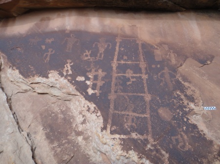
A well known pictograph in Nine Mile Canyon. You may have seen this one featured in National Geographic.  The damage happened long ago before the state intervened on behalf of the preservation of pre-history here.

The name of the canyon is deceiving, being some 70 miles long in total.  The road through the canyon has been recently paved, and is in perfect shape. The is a short section mid-way that remains unpaved, but any vehicle can make it all the way up to the Big Buffalo and Great Hunt petroglyph panels, some of the highlights of the canyon. We turned around there and backtracked, but you can continue north from about mile 37 to Myton. In my opinion, the canyon has more than can be seen in a long day, especially if you plan to do any of the hikes-there are countless rock art site, ruins, and many points of historic interest.  Note that camping is not allowed anywhere in the canyon, other than at the Nine Mile Ranch private campground. So plan accordingly and start your trip into the canyon early, allowing at least a full day.

Great Hunt panel in Nine Mile Canyon. Photo by Gerald Trainor.

One of the more well-known panels in Nine Mile Canyon- called the Great Hunt panel.

Gear Reviews
I always try to highlight a piece of gear in each blog, and for this post I have chosen Rite in the Rain notebooks and Fisher Pens.  It is hard to imagine one without the other. Rite in the Rain notebooks come in many different sizes and page formats, but I tend to use one of the originals- the 3 by 5 inch, spiral top notebook.  It fits easily into any pocket and with its plastic cover, it is virtually indestructible. But the key feature that makes Rite in the Rain products so important to someone who spends a lot of time outdoors is that the pages are waterproof.  I have swam with my notebooks, used them in monsoon rains where I have been soaked through, taken notes during archaeological fieldwork sessions in dripping Central American jungles, and used them for years while in the military. I cannot say enough about the quality and functionality of their products. You can see the spiral bound notebooks and Fisher pens at TwoHandsPaperie.com.

Rite in the Rain notebooks- photo by Gerald Trainor.

Rite in the Rain spiral notebooks- a collection from over the years, including one of Nicolai’s. Archaeological fieldwork, river trips, bikepacking trips, and backpacks are all recorded here.

Fisher pens are the perfect companion writing instrument for the waterproof notebooks. Fisher pen refills are pressurized, and will write upside down, in any temperature you might normally encounter, and on wet Rite in the Rain notebook pages. The Stowaway Pen with a clip is the perfect pen for the 3 by 5 spiral top notebook- the pen slides right into the spiral and clips into place. This pen is also about the most lightweight pen imaginable. The only thing lighter might be just a pen refill by itself! The refills last an incredibly long time as well, and perform perfectly in the desert, mountains, or jungle.

Rite in the Rain spiral notebook with Fisher pen, Photo by Gerald Trainor.

Rite in the Rain 3 by 5 inch spiral notebook with Fisher Stowaway pen securely fastened in spiral binding.

For more on our desert adventures, tracking, and rock art, visit the Desert Explorer website.


September Trip Report, Part Two- Chinle, Comb Ridge, and San Juan Rock Art

18 November 2012

In my most recent post I wrote about the first part of my September trip to Southeast Utah. This post completes my trip report.

My next stop after Grand Gulch was Chinle, Arizona. I made the trip south in order to attend the KTNN radio Drums of Summer celebration. It was the second to last gathering of the summer and being only a couple of hours away I made it a point to take the drive. KTNN radio, the Navajo Nation’s radio station, hosts the Drums of Summer celebrations throughout the summer every year. They are held around the reservation, often in local school auditoriums. They consist of Navajo singers and drummers performing for the audience, along with space for attendees to dance. There are countless raffles and giveaways, and at this particular event there was a pinion fire burning outside with fresh frybread cooking on it. The gathering was in honor of seniors, many of them as I understood it, from the local Chinle senior center. Most of the dancers were older Navajos, and really seemed to be enjoying the event. I spoke to one of the directors from the center for a while, and he told me of the importance of seniors in Navajo culture. I had given this some thought already upon realising that there was in fact a senior center for aging Navajos, people who traditionally would have been cared for in the home by family members, rather than in a western, institutional setting. I sensed that the director was concerned himself with this fact but resigned to it, that it was in the present day unavoidable. He also expressed his dismay with some younger Navajos, telling me how so many seemed to be abandoning their own culture and language in favor of the western world, something I have heard many times from older, more traditional Navajos.

After a night in Chinle I headed north again to Comb Ridge. I was joined on one day of hiking there by two Army medics who were visiting the Chinle area. It was a great opportunity for me to introduce them to the prehistory of the region, and for all of us to make some discoveries in the canyons. I had been along Comb Ridge on both east and west sides many times. I had examined various rock art panels along the way, camped there a number of times, used it to access the eastern drainages of Cedar Mesa, but never really done much hiking there. It has always been my understanding that parts of Comb Ridge were as densely populated as Grand Gulch in prehistoric times, although on a  much smaller scale.  Anyone who has visited the Edge of Cedars Museum in Blanding will note that many recent additions to the museum, and some very important ones,  have come from the Comb Ridge area.

Ruin along Comb Ridge, Utah. Photo by Gerald Trainor.

A ruin in one of the many short canyons along Comb Ridge.

There was also the recent discovery of skeletal remains along Comb Ridge thought to be those of the long-lost traveler Everett Ruess (in the end it was not Ruess). I have to admit that I always found the amount of archaeology from Comb Ridge hard to believe, considering that the canyons are so short. The distance from Butler Wash on the east to the crest of Comb Ridge is not more than a couple of kilometers on the average- very short in terms of resource availability, both food and water. But then I must consider Butler Wash itself, and the fact that Comb Ridge consists of many, many of these short canyons side by side, running east to west, for miles and miles. Also, the tilted Navajo sandstone of Comb Ridge creates perfect building locations, although not as defensible as the shelves and benches of nearby Grand Gulch and its associated drainages, and provides for some canyon-bottom farming locations.

View west from top of Comb Ridge. The drop to the west at this location is about 700 feet down to the road at Comb Wash below. Taken with iPhone panorama application by a fellow hiker.

Those who have read my blogs in the past know that I do not like to give too much away, that my intentions are to leave the discovery to the individual by not providing grid coordinates, maps, or even trail directions. With that said, Comb Ridge is a place that seems to me to allow for endless discovery. Not only that, but the hiking, in my opinion is fairly easy- my 8-year-old son and I will be there visiting the canyons together on our next trip to Utah. You can expect to see cultural and geologic wonders, and an unmatched view if you hike up to the ridge at just about any point along the way.

Detail shot of eastern end of a very large and distinct petroglyph panel along Comb Ridge.

After Comb Ridge I spent a couple of days around Bluff, and took a look around Sand Island, the primary launching point for floating the San Juan river. Besides the boat ramp, you will find rangers in residence, campsites, picnic areas, toilets, water, and petroglyphs. The main, Lower Sand Island petroglyph panel is easily accessible from the road leading into the campground. You can in fact view the panel from your car window if you so desire. It is an extensive and busy panel that covers more than 2000 years of prehistory. 

petroglyph panel near Sand Island, San Juan river, Utah.

One of the many panels near Sand Island, showing animated, possibly dancing figures.

There are many other panels up and down the San Juan from the same time period and possibly much, much earlier. And by much earlier I mean much earlier, with probable representations of Pleistocene megafauna- between 11,000 and 13,000 years ago. The panel I am specifically referring to is known locally as the “Bluff mastodon panel”, but likely represents Columbian Mammoths, two of them, and a possibly coeval, superimposed bison. See the paper in the journal Rock Art Research from 2011 for extensive background on the panel. The paper offers a very clear description and analysis of the panel and supporting arguments for the date that are very convincing. As the paper also points out, there are likely a panel or two from the same period still waiting to be found, and plenty of discoveries within the panels along the San Juan river waiting to be made.

For more on our desert adventures, the San Juan river, and rock art, visit the Desert Explorer website.