Another Spring Break in Canyon Country

21 April 2016

We have just returned from southern Utah once again. It was a late spring break for us, but well worth waiting for April to make the trip. The weather was perfect right up till the end, when we caught a bit of the storm that brought winter back to Colorado. We spent our two weeks in the usual places, revisited some of our favorite canyons, and explored some new ones. We made it a point to include plenty of time enjoying sunrises, sunsets, and the star filled night sky, and more than a few afternoons sitting on the slickrock with a cup of tea.

Blooming holly. Photo by Gerald Trainor.

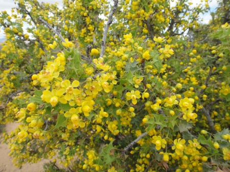
Holly in bloom. The desert was alive with color and fragrance.

Our itinerary brought us straight to southern San Juan county this time. We made an afternoon stop in Moab for final supplies as always, but the weather was so perfect that Moab was too busy for us. April is the perfect time of year for most people- warm days and not too cool nights, without the extreme heat that comes in another month or so. Besides ATV’s and other off-road vehicles, there were mountain bikes everywhere, and more RV’s and camp trailers to be found around every corner than I have ever seen. This was the case everywhere we went- down every road whether it be along Comb Ridge, on Cedar Mesa, or around Green River, where we finished up our trip.

Grand Gulch
We did get a few days of backpacking in this trip. We walked in through Dripping Canyon, had a day in Grand Gulch, and walked out Step Canyon. This is something I have done before, so knew the walk quite well. It was perfect for Nicolai and I- nothing an 11-year-old couldn’t handle. As always, we could have used a couple more days in this short stretch of the canyons- there was just so much to see that we had to choose where to spend our time. For anyone venturing in any time soon, water was not a problem. At least finding drinking water that is. From another perspective, that of walking, it was quite a problem in places. There was so much water in the canyons that we found ourselves skirting pools all along the walk, and especially in Grand Gulch.

Yellow ancestral puebloan pictograph in Grand Gulch, Utah. Photo by Gerald Trainor.

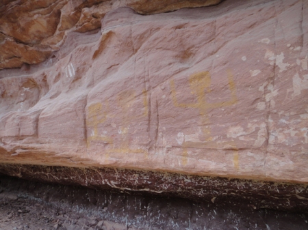
“Yellow Man” panel in Grand Gulch.

Cedar Mesa was a busy place. The Kane Gulch ranger station was packed on the few occasions we stopped in. But once we got in the canyons we only saw, and heard, one group of people. I should say heard more than saw them. Their presence was known to us by their extremely loud voices, yelling I would call it, and their crashing wildly through the brush. We made it a point to discuss this problem with the folks at the ranger station after our walk- noise pollution is  a problem everywhere and especially in such a place as this. I feel that these days so many people don’t know the difference between a place that is… sacred, and say, the grocery store. The analogy I like to use is that I would not come bounding and crashing and yelling into your church, so please don’t come into mine that way. But I suppose, to continue the analogy, I am preaching to the choir here.

Comb Ridge
We have a favorite camp in view of Comb Ridge making it easy to get into the canyons there. We spent five nights on the slickrock at that camp, really enjoying the night sky. I have to make a plug here for one of my more recent equipment purchases. I have been sleeping better than ever these days on an Exped SynMat 7 Sleeping Pad. This inflatable sleeping pad has an integral pump which inflates it in just a couple of minutes. No blowing it up by mouth involved! I have the synthetic fill version which is rated at an insulation value of 4.9, but there is a higher rated pad that has down filling.  I use it at the truck and on the river- it’s just too heavy for me to carry on a backpack. The pads are not cheap, but if you are struggling with getting a good night’s sleep on a thinner pad, you may want to give one a try.

We spent a couple of days exploring Comb Ridge, and as always found more ruins and rock art, middens and moki steps, sweat lodges and seasonal campsites. Comb Ridge is truly a place where one can learn about the varied archaeology of the Northern San Juan region all in one place. One ruin we visited stood out in the amount of mud that was plastered on the walls. The ruin lacked for stone, but still held together well with mud. Looking at it you could see the way it was applied, in great masses, each appearing to be left to sag and dry before the next mass was applied. The interior of the walls had niches built-in, and the end walls were curiously rounded, as if they were not continued across the front, but were left open.

Ancestral Puebloan structure in Comb Ridge, Utah. Photo by Gerald Trainor

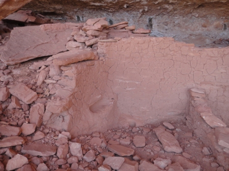
Comb Ridge ruin with walls lacking in stone but showing an abundance of mud.

Ancestral Puebloan dwelling in Comb Ridge, Utah. Photo by Gerald Trainor.

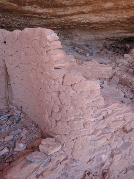
End wall of plastered ruin showing rounded finish. Note the thick mortar beds between the thin pieces of sandstone.

There is always so much to see, and to write about afterwards, on our Utah trips. But for now it’s back to preparation for the next trip. In about a month we are back in southern Utah for more archaeology at Nancy Patterson Village. For more about us and our desert adventures visit the Desert Explorer website.


September Trip Report, Part Two- Chinle, Comb Ridge, and San Juan Rock Art

18 November 2012

In my most recent post I wrote about the first part of my September trip to Southeast Utah. This post completes my trip report.

My next stop after Grand Gulch was Chinle, Arizona. I made the trip south in order to attend the KTNN radio Drums of Summer celebration. It was the second to last gathering of the summer and being only a couple of hours away I made it a point to take the drive. KTNN radio, the Navajo Nation’s radio station, hosts the Drums of Summer celebrations throughout the summer every year. They are held around the reservation, often in local school auditoriums. They consist of Navajo singers and drummers performing for the audience, along with space for attendees to dance. There are countless raffles and giveaways, and at this particular event there was a pinion fire burning outside with fresh frybread cooking on it. The gathering was in honor of seniors, many of them as I understood it, from the local Chinle senior center. Most of the dancers were older Navajos, and really seemed to be enjoying the event. I spoke to one of the directors from the center for a while, and he told me of the importance of seniors in Navajo culture. I had given this some thought already upon realising that there was in fact a senior center for aging Navajos, people who traditionally would have been cared for in the home by family members, rather than in a western, institutional setting. I sensed that the director was concerned himself with this fact but resigned to it, that it was in the present day unavoidable. He also expressed his dismay with some younger Navajos, telling me how so many seemed to be abandoning their own culture and language in favor of the western world, something I have heard many times from older, more traditional Navajos.

After a night in Chinle I headed north again to Comb Ridge. I was joined on one day of hiking there by two Army medics who were visiting the Chinle area. It was a great opportunity for me to introduce them to the prehistory of the region, and for all of us to make some discoveries in the canyons. I had been along Comb Ridge on both east and west sides many times. I had examined various rock art panels along the way, camped there a number of times, used it to access the eastern drainages of Cedar Mesa, but never really done much hiking there. It has always been my understanding that parts of Comb Ridge were as densely populated as Grand Gulch in prehistoric times, although on a  much smaller scale.  Anyone who has visited the Edge of Cedars Museum in Blanding will note that many recent additions to the museum, and some very important ones,  have come from the Comb Ridge area.

Ruin along Comb Ridge, Utah. Photo by Gerald Trainor.

A ruin in one of the many short canyons along Comb Ridge.

There was also the recent discovery of skeletal remains along Comb Ridge thought to be those of the long-lost traveler Everett Ruess (in the end it was not Ruess). I have to admit that I always found the amount of archaeology from Comb Ridge hard to believe, considering that the canyons are so short. The distance from Butler Wash on the east to the crest of Comb Ridge is not more than a couple of kilometers on the average- very short in terms of resource availability, both food and water. But then I must consider Butler Wash itself, and the fact that Comb Ridge consists of many, many of these short canyons side by side, running east to west, for miles and miles. Also, the tilted Navajo sandstone of Comb Ridge creates perfect building locations, although not as defensible as the shelves and benches of nearby Grand Gulch and its associated drainages, and provides for some canyon-bottom farming locations.

View west from top of Comb Ridge. The drop to the west at this location is about 700 feet down to the road at Comb Wash below. Taken with iPhone panorama application by a fellow hiker.

Those who have read my blogs in the past know that I do not like to give too much away, that my intentions are to leave the discovery to the individual by not providing grid coordinates, maps, or even trail directions. With that said, Comb Ridge is a place that seems to me to allow for endless discovery. Not only that, but the hiking, in my opinion is fairly easy- my 8-year-old son and I will be there visiting the canyons together on our next trip to Utah. You can expect to see cultural and geologic wonders, and an unmatched view if you hike up to the ridge at just about any point along the way.

Detail shot of eastern end of a very large and distinct petroglyph panel along Comb Ridge.

After Comb Ridge I spent a couple of days around Bluff, and took a look around Sand Island, the primary launching point for floating the San Juan river. Besides the boat ramp, you will find rangers in residence, campsites, picnic areas, toilets, water, and petroglyphs. The main, Lower Sand Island petroglyph panel is easily accessible from the road leading into the campground. You can in fact view the panel from your car window if you so desire. It is an extensive and busy panel that covers more than 2000 years of prehistory. 

petroglyph panel near Sand Island, San Juan river, Utah.

One of the many panels near Sand Island, showing animated, possibly dancing figures.

There are many other panels up and down the San Juan from the same time period and possibly much, much earlier. And by much earlier I mean much earlier, with probable representations of Pleistocene megafauna- between 11,000 and 13,000 years ago. The panel I am specifically referring to is known locally as the “Bluff mastodon panel”, but likely represents Columbian Mammoths, two of them, and a possibly coeval, superimposed bison. See the paper in the journal Rock Art Research from 2011 for extensive background on the panel. The paper offers a very clear description and analysis of the panel and supporting arguments for the date that are very convincing. As the paper also points out, there are likely a panel or two from the same period still waiting to be found, and plenty of discoveries within the panels along the San Juan river waiting to be made.

For more on our desert adventures, the San Juan river, and rock art, visit the Desert Explorer website.


September Trip Report, Part One- Fish Creek Canyon and Grand Gulch

13 October 2012

I was lucky enough to have the last two weeks of September to myself in the Grand Gulch area of southeast Utah this year. I managed to spend about a week in Grand Gulch and on Cedar Mesa, and a few days hiking Comb Ridge. During my hikes I found countless rock art panels- a few that I revisited, but many new ones, and ruins all along the way. I also made a side trip down to Chinle, Arizona for an evening of Navajo singing and dancing sponsored by KTNN, the Navajo Nation’s radio station. The weather was perfect, not too cold, and warm during the day. There was one night and morning of sustained rain while I was down in Grand Gulch. There was enough rain to send water cascading off canyon rims and to turn the previously dry canyon bottom into a fast-moving stream.

My hikes started out with a few days in upper Fish Creek Canyon- 3 days and 2 nights to be exact. I entered from the Fish and Owl trailhead and then walked up the Main Fork and came back down the South Fork. This was a section of canyon I had wanted to visit for at least the last ten years, ever since my first trip into lower Fish and Owl Creek Canyons. The head of the canyon seems very inviting as you drive across it on Highway 95. Looking down canyon, it appears that it would be a gradual, even descent on slickrock canyon bottoms. This is not really the case, especially up high.

Entrance to Fish Creek Canyon, view north from canyon rim after walking across mesa. The walk is rough in the canyon bottom down below.

Since I was traveling alone and not carrying any technical canyoneering gear (no ropes, harness, slings) I started from below and worked my way up. It always feels safer to me to work this way- if I can climb up something I can usually climb right back down it. Coming in from above and following the canyon bottom in an unknown canyon often requires a lot of climbing out- around- back in. This adds the potential for becoming “rimrocked” while trying to find a way back in. Then there is the possibility of downclimbing and coming to impassable pouroffs requiring backtracking and climbing back out. Of course the same will then be true for traveling up canyon, but the potential for getting into trouble is minimised, in my opinion, by traveling up canyon.

Upper Fish Creek Canyon is not lower Fish Creek Canyon, not that lower Fish is that easy of a walk. The canyon started out with water everywhere, and associated brush, requiring lots of skirting of pools, and some climbs around bigger pools at pouroffs. I found pools of hundreds and even thousands of gallons of water on my hikes in Fish Creek, Grand Gulch and side canyons.  I should mention that just a couple of weeks before my arrival there was a tremendous downpour lasting some 10 hours at certain locations. This filled the canyons with water, scouring them out and depositing debris, and creating problems for navigation both in the canyons and on the mesa top. I was told by the rangers at Kane Gulch that “the narrows” of Grand Gulch had become a swimming hole at the bottom, and was jammed with debris at the top. There was a group of volunteers clearing out brush and rebuilding trails in that area while I was there.

Pothole- upper Dripping Canyon, Cedar Mesa, Utah. Photo by Gerald Trainor.

Large pothole holding thousands of gallons of water, upper Dripping Canyon.

Back to Fish- canyon bottom walking was rough at times. Besides water and brush, there was plenty of climbing over, under, and around boulders higher up in the canyon. Slots were a problem higher up, requiring climbing out, skirting on a bench, and climbing back in. The vegetation changes as I gained elevation traveling up canyon occurred in conjunction with the slots- once I started seeing Ponderosa and other pines, the canyon narrowed and started to slot. I encountered more slots coming back down the South Fork than moving up the Main Fork. A rope, harness, and some slings would have made for an interesting experience in these upper sections.  I spent a few hours on benches skirting slots on  the way back down.

Slot in upper Fish Creek Canyon, South Fork. Don’t be deceived by the photo- it is about 40 feet or so down to the water. This would have been fun with rope and harness.

After I finished up with Fish Creek Canyon I headed across the mesa into Grand Gulch proper. I entered via Dripping Canyon, which is passable. That is about all I will say on the subject; it is a fun one, and can be done. I spent the afternoon in Grand Gulch and headed out via Step Canyon, where I stayed the night. Along the way I passed by some of the well-know panels and ruins in the canyon bottom. If you are new to Grand Gulch, it was at one time very populated. This is evident as you walk along the canyon bottom; all you have to do is look up every now and then to see ruins and rock art.

Pueblo dwelling, Grand Gulch, Utah. Photo by Gerald Trainor.

Large, well-preserved, and defensible ruin in Grand Gulch.

Part two of my September Trip Report will cover hikes in Comb Ridge, rock art along the San Juan River, and my visit to Chinle, Arizona. I will also include an update on my tracking book bibliography. Look for that in about a week. In the meantime, for more on visiting southeast Utah, see the Desert Explorer website.


Summer Plans- The Escalante and the Dirty Devil

20 February 2011

It has been quite some time since I have posted, and again I apologise for this. It has been a busy winter, which is a good thing- a busy winter means a good, long summer in the desert.

My last post, and updates, dealt with the shooting of the ranger in Moab. He has been at home for some time now and is recovering from his ordeal. The suspect in the shooting has still not been located. He is undoubtedly in a crack or under a rock somewhere along the Colorado River south of Moab. His bones will be found some day, and the mystery of his disappearance will be solved.

The Dirty Devil River
I have recently been in communication with various river runners who are preparing to float the Dirty Devil River. Jason and crew look like they will be the first to float of the bunch of us, and they may be setting a new standard for the river by floating in a cataraft, although the final decision is still up in the air. As Frank puts it, “Whats the worst that could happen? Abandoning the boat and barely making it out alive?”  It’s going to be an adventure no matter what. They will be putting in at the very end of February, taking advantage of high water, so they should be fine. Next will be Seymour and crew, putting in at the end of March. Next would be Frank and the Kokopelli crew who may run it again, and Nicolai and I plan to float it in June.

View down river just below put in- low water, sand bars, and mud.

The river can be a tough one, with the channel tight and deep at one corner, then playing out into a wide mudflat a few inches deep 100 meters later. The mudflat scenario requires getting out and dragging your craft through. This sums up my experience during my first few days on the river when I did it in 2008- jump in and float a bit, get out and drag a bit. Repeat for six hours or so. But the rewards far outweigh the… great workout you’ll get along the way. The river is quiet, isolated, full of wildlife and incredible scenery.

Nicolai and I will float it later in the summer, during the dragging season. Robert may join us on, but his plans are not finalised. We are choosing to do it then simply because we prefer the hot, long days over the shorter, potentially much colder late winter days. I know I’ll be dragging, and Nicolai will be walking, but it will be an adventure he will never forget- the most important part. For more on the Dirty Devil visit our website pages and see the main blog post about it for all the comments by those who’ve floated it.

The Escalante Trek- Part Two
Two summers back Robert and I did a long walk down the Escalante River-literally down the river- from the bridge on Highway 12 to 25 Mile Wash and out. It amounted to about 50 miles of walking. This summer I will revisit the area to “finish up” the river walk. I plan to use the Moody Canyon trailhead as an entrance, walk to the river, up river to connect with the previous end point at 25 Mile Wash, then down river to Coyote Gulch. From there I’ll head up Coyote, back across the mesa and into Scorpion Gulch, ultimately heading back out East Moody. That is the plan. I still have a bit of research to do regarding access at the head of Scorpion Gulch, and using East Moody as an exit. I will be traveling as light as possible and won’t be carrying any canyoneering equipment, so finding a way in off the mesa is a necessity. I will have about two full weeks to accomplish the trek, which should be no problem. It looks as though it will be a solo this time. I’ll post more on the planning as it comes together, and of course a trip report afterward.

Tracking
I haven’t written much about tracking lately, but it is always on my mind. Every fresh snowfall affords easy tracking lessons, and every time we get fresh snow we make it a point to seek out some track or other- across the front yard, down the alley, or out in a field- and try to sort it out. Reading fresh tracks in fresh snow and really figuring them out helps create a solid base of knowledge for the future when tracks are not so clear and not so easy to read.

House cat tracks in fresh snow.

Speaking of reading, I am revisiting a tracking book that I have had on my shelf for a while now. Tactical Tracking Operations by David Scott-Donelan presents the author’s experience as a military tracker with most of the examples coming from the Rhodesian bush wars. This is a book about tracking human quarry, but is a worthwhile and interesting read for anyone  who tracks. While the book is probably not something you would read word for word to a six year old, there are plenty of tracking stories in it that my six year old enjoys hearing. It is a good compliment to the best tracking book out there, Bob Carrs’ The SAS Guide to Tracking, and Tom Brown’s field guides, the books I started with. All these books are available at Amazon.com


Trip Report- Swell Rock Art, Grand Gulch, and Johns Canyon

12 October 2010

We are back in Colorado after two and a half perfect weeks in southeast Utah. You never know what to expect at the end of September, but we had great weather with unseasonably warm days and nights. The skies were clear,  filled with stars, planets, and a full moon. Temperatures were a warm 85 to 90 or so during the day, dropping to around 50 to 55 at night.

Rock Art and Green River Town
We began our trip by visiting a few rock art panels in the San Rafael Swell area. All the panels are named, quite well known, and are found on most maps. The Head of Sinbad panel, the Lone Warrior panel, and the Black Dragon panel are all rather easy to find and get to, provided you have a four wheel drive, or are prepared for a little walking. All three panels consist of pictographs, with petroglyphs also found at the Black Dragon panel.


Head of Sinbad panel, San Rafael Swell. The detail in this panel is really amazing, the lines are very fine and crisp.


The Lone Warrior panel is as the name implies, a single, isolated image. The pictograph is exposed to sun and the elements and as a result is not as clear as the Sinbad panel.


Along the way we stopped at the town of Green River where they were having their annual Melon Festival. The honeydew, cantaloupe, and watermelon were at their peak of ripeness and sweet and juicy. We also made a visit to Crystal Geyser and spent an afternoon there, alternating between walking through the cold water erupting from the geyser, and then dips into the warmer water of the Green River. There is a new coffee shop in town, right at the corner of Broadway and 150 West- it is a few doors away from the Melon Vine grocery store.  They serve Illy coffee- stop in and support them. See our Desert Links page for more on Green River.

After we left the Green River area we did our usual drive south towards Cedar Mesa with stops in Moab, along the edge of Canyonlands, and in Blanding. Matrimony Spring in Moab is still running strong, and there was nothing in the paper and no talk around town about closing it down again.

Horsethief Road
One important piece of news out of the Moab area had to do with a torrential downpour some time in August. The storm literally washed away the switchbacks on Horsethief road coming up from Mineral Bottom. The road is impassable by any vehicle (even a Toyota Land Cruiser.) It can be walked, and I could portage a mountain bike up through the washed out spots, and get a good workout doing it. According to the Grand Junction Sentinel, the damage is going to cost Grand County about 2.5 million dollars to fix, and it will take about 6 months to do so. The estimated loss in revenue is about 5 million dollars! So if you are still planning a river trip with a takeout at Mineral Bottom, or a ride of the White Rim, you will want to review your plans. See the National Park Service website for more info and great photos.

Cedar Mesa and Grand Gulch
We did a couple of overnight backpacks in Grand Gulch and its tributaries. On our first overnight we walked in on Government Trail and Nicolai finally got to see Big Man Panel, something he was very excited to do. Our next overnight took us down an unnamed canyon at the lower end of Cedar Mesa known locally as Lookout Canyon. This walk is not for the faint of heart or those that are out of shape, especially when it comes to exiting up the left drainage if you do the loop. Be sure to see our Lookout Canyon Dayhike page at the Desert Explorer website for more details on this hike. The hike is certainly worth it if you are up for it. Nicolai enjoyed the solitude, and we entered the canyon the night after a huge downpour, so we were negotiating not only downclimbs, house-sized boulders, pouroffs, and brush, but also pools and potholes filled with fresh rainwater. Red spotted toads were out in force after the rains. It was a great adventure, especially for a 6-year old.


Nicolai sketching the Big Man.


Johns Canyon Bikepacking Trip
Next we drove into Johns Canyon as far as is possible with a full-sized vehicle (Johns is spelled with no apostrophe, this is not a typo). After crossing over the drainage in the canyon bottom and heading south out of the canyon, there is a washout that apparently will not be repaired as it has been there for a number of years now and is just getting worse. It stops vehicle travel altogether, although dirt bikes and possibly ATV’s can get past. From this point we got on our bikes and rode most of a day to an even rougher section of what was once the road to the mouth of Slickhorn Canyon. Nicolai made the decision at this point that we should turn back and camp at a nearby switchback. It was a perfect campsite, allowing us to watch the sun set, then Venus, and Jupiter rise in the east.


Petroglyph in Johns Canyon- man with headdress, over a meter high.


Along the way we saw a number of rock art panels. I am sure we missed a few as well. It seems that this road was also a route used by the ancient inhabitants of the area to reach the San Juan River at the mouth of Slickhorn Canyon. If you do this ride, and plan to go all the way to the river, I recommend not hauling a trailer as we did. Panniers would make the portages through the washouts much easier. Be sure to carry a patch kit and extra tubes!

Unschooling in Southeast Utah
Adventures such as these are a large part of our unschooling experience. Nicolai does not attend school; his learning is largely based on what we decide to do on any given day, and on our travels and adventures, wherever they may take place. Learning for us occurs on many levels, but it is always occurring. For example while on this trip we studied not only the rock art of the basketmaker and Puebloan cultures who inhabited the area, but many other aspects of their cultures such as their technology, farming practices, building methods, food storage and preparation, and hunting strategies.

On our trips we always pay attention to astronomy- the planets and their appearance and disappearance, moon phases, and stellar navigation. On this trip we talked about how our view of the stars and planets differ between the northern and southern hemispheres. We always focus on geology while in Utah- discussing geology there is as necessary as breathing. Utah is a living geology textbook. We incorporate engineering and math into our discussions of ancient cultures, as well as the spiritual aspects of their lives. We discuss military tactics and strategies on our trips as well- Puebloan cultures and their choices for habitation lend well to this topic.  And of course there is the flora and fauna of Utah and our ongoing study of primitive skills. The point here is that learning is not something we do at a desk, and never will be. Learning comes with our daily experiences and we take advantage of every one of them to grow and learn and expand our horizons. For more of our thoughts on unschooling and nature, visit the Desert Explorer Wilderness Kids pages.

Next on the agenda: a trip to the Colorado Canyons. It has been years since I have visited the area, and I have been trying to get back there ever since. A few days exploring Jones Canyon from its mouth is in the works for early November. Check back for more on that trip. See our Colorado Canyons pages for more information on the area.


Mid-trip Blog Post- Kayenta, Arizona

12 June 2010

This morning we are at the Wetherill Inn in Kayenta, Arizona. We’ve been out in the bush for the last 10 days and decided to do a hotel night before heading on today to Navajo National Monument. The highlight of our stay in Kayenta was our visit to the Navajo Code Talkers exhibit. It is housed at the Kayenta Burger King, and the Visitor’s center next door. We spent about two hours looking over the exhibit, reading about it, and watching part of a video on the Code Talker program. It is a little-known part of history and will tell you something about the patriotism and fortitude of the Navajo people. If you are interested in World War II history, and you will be in the area, you will not want to miss this. Here are a couple of random links to the exhibit- Roadside America link, Bridge and Tunnel club link.

The weather has been as it usually is in the  summer in the region- sun, sun, more sun, and wind. The temperatures have been hot and the wind has been a constant, ranging from a breeze to gusts strong enough to blow our gear away. The wind has been welcome though, as the gnats up in Utah have been a problem.  We have experienced a change coming down into Arizona- the wind was stronger here yesterday, blowing in a storm. While we saw but a few light cumulus clouds during our time in Utah, yesterday here in Kayenta those few light clouds turned to dark storm clouds. We had a shower in the afternoon and a full-on storm with thunder, lightning and driving rain in the middle of the night. It would have been a fun night to be in the tent!

We stayed at some of our usual camps over the last 10 days, and found a couple of new ones. We did lots of exploring and driving of dirt roads and two-tracks. We found ghost towns, old mines, a historic grave out in the desert, ruins, and lots of rock art. We visited a few rock art sites by truck along the way, and saw countless panels on our 3 days in lower Grand Gulch.

Barrier Canyon style rock art near Thompson Springs, Utah.

We did a 3 day backpack from Collins Canyon trailhead down into Grand Gulch towards the San Juan. I have done it before but, as is always the case, saw ruins and panels that I walked right by before. Visibility changes year by year, and season by season, but also by time of day and direction of travel. For example, walking down-canyon in the morning you might see a huge panel that will be invisible due to the bright sun if you were walking up-canyon in the afternoon. All the more reason to re-visit old hikes and spend more time out in your favorite places! There was water in the lower part of Grand Gulch, though not the cleanest and not as abundant as I have seen it before. The potholes and seeps are drying up and if this continues water will be scarce within the next couple of weeks.

For more information on Grand Gulch and rock are of the region, visit the Desert Explorer website. We’ll be back in Colorado late next week. Look for a more extensive trip report then.


The Archaeology of Southeast Utah- Ruins, Rock Art, Museums, and Looters

28 June 2009

On our recent trip to southeast Utah my son and I visited many ruins and even more rock art panels.  We saw everything from archaic anthropomorphic petroglyphs to Barrier Canyon pictographs to mud handprints to cowboy graffiti from early last century. We spent a long afternoon at the Edge of Cedars Museum in Blanding. If you visit the area make it a point to stop at the museum for at least a couple of hours. It is built adjacent to a pueblo that has been extensively excavated and reconstructed.  There is even a kiva that you can enter. They have an amazing collection of artifacts including four Cottonwood plates that appear to have been made yesterday and four hafted stone knives, from the same cache, that are as well preserved as the plates. I have never seen wooden plates before, nor knives in this condition, from anywhere in the southwest.

Rock Art

Nicolai and I visited some of the more well-known panels close to Moab including Courthouse Wash panel, Moonflower panel and others along Kane Springs road, and one lesser-known panel north of town. The most impressive rock art on our trip was during our backpack on Cedar Mesa.

step_petros

Rock art on boulder in Cedar Mesa canyon.

The panel at left was one of about 6 panels located on some very large boulders at the base of a ruin.  The ruin had about 15 rooms and a number of associated granaries, with other dwellings located nearby.  In all, within about a 300 meter radius, there were likely 25 or so rooms that could have been used as living quarters.  There were about 10 granaries in total associated with them.

The boulder in the photo has light patination. Most of the others are much darker.  The petroglyphs on the boulders and ruin walls include a few different human forms including horned anthropomorphs, kokopelli figures, and the Abajo-La Sal Style human form in this photo (see Sally Cole’s Legacy on Stone, page 159).  There were also bighorn sheep, spirals and concentric circles, zigzag lines or snakes, birds- turkey and quail, mazes or maps, a staff, and atlatls. This gives a short list of the elements visible on the panels at this ruin.  One could spend days or weeks exploring all the elements, their time spans, and meanings.

cowboy_intial

Initial and date graffiti on a rock used for grinding by the ancient inhabitants of this rock shelter.The rock shelter has the remnants of at least two granaries, as well as debris from years of use by cowboys.

Besides the petroglyphs the same location had mud handprints and initials and dates of cowboys that likely spent some time tending cattle in the canyon bottom. The photo above shows one of the initial and date sets.  It reads “EH”, with a date of 1914. I gather that EH was not entirely literate based on the backwards “9”. There are two other sets at this location, one dated 1914 and the other 1940.

step_mud_hands

Mud hand prints in Step Canyon.

A Few Words About Ruins

nico_step_ruin

Nicolai peeks into one of the rooms.

The ruins in Grand Gulch in general are some of the best preserved that can be found.  Those we visited are well-preserved for the most part, with what might be described as medium-quality masonry, having solid walls with the fingerprints of the builders still visible.  Many doorways are still intact, with their pine lintels as if they were installed yesterday. I have stressed the importance of helping to preserve ruins and rock art to Nicolai since his first visit. When we visit I remind him about not climbing or leaning on, or even touching any of the ruin walls, and especially the rock art. He has already developed an appreciation for these irreplaceable cultural treasures, and an understanding of the importance of preserving the ruins, rock art, and artifacts in their original context for scientific purposes. He also understands that we are respectful of the old people and their descendants when we visit these places.

Looters

The big news during our trip came from the towns of Blanding and Monticello. On Wednesday, June 10th, the Feds arrested 24 people, mostly in Blanding and Monticello, for artifact theft.  There had been an undercover operation going on there for the last couple of years.  See the Salt Lake Tribune or LA Times article for the complete story. The names on the list included a teacher, David Lacy (who apparently had the same troubles in the past), James Redd, the local physician (who committed suicide the next day), and one of the more respected people in Blanding, the man in part respponsible for putting Blanding on the map- Harold Lyman. Lyman also helped protect the ruins and found the Edge of Cedars Museum. The locals were very upset, both in Blanding and Monticello, as many people in these small communities were impacted in some way by the arrests.  Some are claiming that the Feds used undue force when making the arrests, the same claim that was made after the last raid of the area 15 years back or so for the same reason.

There is never a less-than exciting moment when we visit southeast Utah.  I will watch as the story of the looters unfolds and include any news in future posts.

courthouse_wash

Final shot- Barrier Canyon pictographs at Courthouse Wash panel.


A Cool and Windy Trip to Southeast Utah

17 June 2009

Nicolai and I have returned from our latest adventure in the desert and we are already preparing for the next, just weeks away. We had a great time, despite winds every day, clouds, cool temperatures, and a few light rain showers now and then. Happily, we were spared from torrential downpours, and flash floods.  Overall the weather was strange for this time of year.  We expected temperatures of 90 degrees and above, especially in the canyons, but the warmest days we experienced were right around 80 degrees.

nico_goggles

Enjoying dinner during a windstorm.

The winds were the worst part for both of us, but my resourceful and prepared four year old son made me find his ski goggles for him just before we left saying something about the wind always blowing in Moab. I grudgingly dug them out and put them in his gear box, thinking it would be another item that would be unpacked without being touched. I was wrong and he was very happy that he had them. Windstorms didn’t keep him from having fun, or eating his dinner.

We camped at a few of our favorite sites along our route, and found a few new favorites, especially in the Moab area.  One of our long-time favorite camps we call Camp 158, after the number of the BLM road leading to it. It is right on the border of Canyonlands National Park. We spent two nights there, enjoying the long views west across Canyonlands and the Abajo Mountains and south to Navajoland, the sunsets, coyotes, and the near- full moon when it managed to emerge from behind the clouds.

nico_camp158

Nicolai at sunset at Camp 158, near Canyonlands National Park.

We had some fun hikes including one in Moab in Courthouse Wash- we did this on a hot afternoon and took advantage of the cool water running through slickrock pools. We also hiked near Canyonlands in Hatch Ranch Canyon, and on Cedar Mesa in Step Canyon. The Step Canyon hike was an overnight.  We ended up walking about 7 hours each day, a lot of walking for a four year old. But he did great and was excited throughout the entire walk. We visited many ruins and looked at even more rock art panels on our hikes and around the Moab area.  I will discuss them more in an upcoming post.

nico_chopper

Nicolai shows off a quartzite chopper he found lying on the slickrock.

As usual Nicolai spotted lithic artifacts everywhere- cores, scrapers, choppers, and lots of flakes. On our overnight his eyes were open for potsherds. They were easy to spot in the bottom of the wash, and when their frequency increased, it told us there was a ruin close by. We studied them thoroughly- the different forms of corrugated wares, the polychromes, and the painted black on white sherds that are his favorite. He made some sketches of the linear designs to paint on his own pots at home. We have been working on learning handbuilding techniques and firing our pots in the firepit in our backyard.

Nicolai studies potsherds on the edge of a midden.

Studying potsherds on the edge of a midden.

We did lots of exploration on dirt roads.  We managed to find our way to River House ruin and the main Butler Wash petroglyph panel via Comb Wash and the Mormon Trail.It was a fun drive in the Landcruiser and felt very different from the approach we are used to- by boat floating down the San Juan River. For those interested- if you do the drive you need a four wheel drive- the rocks and sand and wash driving demand it.

prince_plume

Princes Plume, seen on a the rim of White Mesa.

We studied and photographed a number of plants that we plan to post on the Desert Explorer website. We have been trying to add a new plant or mammal or lizard when we have the time, with the eventual goal of covering the more common flora and fauna of the Southwest desert.  We will soon add Prince’s Plume, Golden Currant, Mountain Mahogany, and Saltbush.

After our backpack on Cedar Mesa we drove down to Mexican Hat for breakfast, as we often do.  The Olde Bridge Grille has excellent American breakfasts- eggs, potatoes, toast, pancakes, and many forms of breakfast meat.

After breakfast we headed south to Monument Valley.  We had every intention of finding some mutton stew, but were unsuccessful. Next time we’ll drive on to Kayenta to be sure we find it.  We resupplied at Gouldings Market, and sat up near the park visitor’s center watching the mesas while we ate our lunch.  We walked around the new hotel and visitor’s center there- I always find them, and the visitors we encounter, nearly as interesting as the natural features we have come to visit. Busloads of  French and Russian tourists were visiting that afternoon.

mv_mittens

Monument Valley, The Mittens.

Finally we headed back towards Moab and on towards I-70 for the drive home over the mountains. And now we are cleaning up and repacking for the next journey.


Backpacking in the Escalante and a Grand Gulch Dayhike

26 August 2008

A Few Days in the Escalante

Robert and I spent five days in the Escalante from 17 through 21 August, 2008. Four days were on the trail, the fifth day was at the trailhead camp that turned out to be much nicer than we expected. Our hike took us from the Horse Canyon trailhead down Horse Canyon to the Escalante River. I hiked up the river one day to The Gulch and took a look at The Gulch, about two kilometers up, and a few of its short side canyons before returning the same way. The Gulch was quite choked up, even with the recent rainstorm, and there were no tracks from other hikers visible at all. Our way out was up Horse Canyon to Little Death Hollow for a muddy walk through the slot.

An old cowboy line shack in Horse Canyon, once a train caboose.

Recent rains in the area had washed out roads throughout southeast Utah, including in the Escalante. Luck was with us though, and we were among the first to drive on recently graded roads. We had no trouble at all navigating the roads to the Horse Canyon trailhead. On the way out I drove the Wolverine Loop road back out to the Burr Trail and down the switchbacks to the east. I drove all the way to Bullfrog for (expensive) gas on the backroads. A ranger in the town of Escalante advised Robert that it wasn’t the right time of the year to go down these canyons, that they might be impassable, or choked with underbrush. He even said that the Horse Canyon trailhead afforded no good camping. Our experience was nearly the opposite.

Four days was more than enough for this hike, three would have been adequate. We chose to spend two nights at our camp right on the Escalante River. The river had calmed down by then and the water was running clean. There was no settling of the river water necessary, we just filled our bottles and Dromedary bags and used the Miox to purify the water. We took advantage of the cool water for swimming many times during our two days there.

The narrows of Little Death Hollow.

The hike up the river to The Gulch was interesting. Half of the walk was in the river, the other half following cow trails through shortcuts in the brush as the river meandered beside me.

The walk in the river wasn’t bad, kept me cool and it made me wonder about doing the entire river that way- starting out at the highway bridge north of the town of Escalante and walking down to Coyote Gulch, about 75 miles away.

It would be an interesting way to see the river. If you do any navigating of the river on foot, be sure to bring a solid pair of shoes or boots for wading.

Little death Hollow is a great slot canyon with kilometers of narrows to enjoy. Because of the recent rains it got quite muddy at times. At one point we even climbed out to skirt what appeared to be as much as 100 meters or more of water and choke stones on the canyon bottom. We were prepared for backpacking, not canyoneering, and this seemed to be the safest and most comfortable way around. I will surely return to this canyon for more exploration at another time.

Upper Grand Gulch

After leaving the Escalante I managed to spend one day hiking on Cedar Mesa in the upper end of Grand Gulch. It was a hike I had been meaning to do for years, and with it I have hiked all but about 3 kilometers of Grand Gulch. I parked right at the intersection of Highways 95 and 261 and walked right into the drainage. It took me about 3 1/2 hours to reach the junction with Kane Gulch, about 10 kilometers down canyon. I took a quick look at Junction Ruin, and returned the same way, although I veered west about 4 kilometers from my starting point where a drainage comes in from the west.

Ruin in upper Grand Gulch.

The hike was easy, except for two pouroffs about one kilometer up from the junction with Kane Gulch. One of them required a jump down, and a climb back up. The other I just skirted by climbing through a boulder field. There are at least a few ruins in this part of the canyon that are well worth seeing. The one pictured above, along with another about 500 meters away from it, were built with bright red sand from the wash in Grand Gulch immediately adjacent.  The red sand mortar had stained the stones and both ruins stood out among the deep green of the Pinyon, Junipers, Cottonwoods, desert Aspens, and Mormon tea.  They were easily visible from the canyon bottom below.

For more info on both of these hikes, and others in both areas, visit the Desert Explorer website.


Dirty Devil River, Desert Explorer Update, Four Corners Fugitives

26 January 2008

Dirty Devil River Float-
I made a decision this week to float the Dirty Devil River earlier than I had originally planned. Since I am going to ride the White Rim in August, the plan now is to float solo at the end of May, over the last two weeks of the month. I had thought about floating in August, but was worried about the flow of water then. In May that should be less of a problem. I am giving myself 10 days to do it, but will allow two or three days extra in my itinerary in case I find canyons that must be explored. From all the information I have found on the river, much of it, in the upper reaches at least, seems to be a muddy stream. But I am sure there is plenty to see along the 90 or so miles of the trip from near Hanksville down to Hite. There are some really amazing canyons along the way, judging by the topography on the map. Of course I will carry a pack and hiking gear; I will likely carry a larger pack for an overnight or two if my research and map reconnaissance deem it necessary, and I will make sure they do.

Logistically the only hurdle to work out is a shuttle from Hite to the put-in above Hanksville. I will call Tag-A-Long Expeditions in Moab in the next week or so to see if they have any plans to be in the area at the end of May. It is probably too early for them to know their schedule for sure, but I will let them know that I am interested. Once I park my truck at Hite Marina, and get the ride to the put-in, I am free for the next couple of weeks to explore. I am really looking forward to the float, even though it may be challenging in terms of navigation- dragging the boat across sandbars and through shallows, in the heat of the summer no less, will be a big part of the float from the little I have read about it.

Desert Explorer Website-
I added three new pages to the Cedar Mesa Trip Guides page on the website this week. Kane Gulch Ranger Station to Toadie Canyon Loop; Green House Canyon, Grand Gulch, Pine Canyon, Step Canyon Loop; and Coyote Canyon to Shiek’s Canyon Loop are now online. I will revisit them in the coming weeks to edit and add to the content, and post another photo or two once I locate the images.

I did some editing of the Backpack Foods Page this week, added more content, the first recipe. This page will see more work in the near future as well- I will add at least a few more recipes this week. As with all my pages, I create them and add to them as time allows. My goal is to at least post introductions on the topics that I feel are necessary and important to desert backpacking and hiking. Then I can work on them when I have the time, 10 minutes here, a half hour there. I still have much work to do to get the site to a point that I feel makes it comprehensive. I am about half way to my ultimate goal. So keep checking back.

Four Corners Fugitives Search-
This week I went back to my notes about the Four Corners Fugitives and began work on Chapter Five. It should be ready for posting this week. If you are unfamiliar with this topic, I will offer a summary:

In late May of 1998 a water truck was stolen near Durango, Colorado. Three local men, Jason Wayne McVean, Alan Lamont Pilon, and Robert Matthew Mason were ultimately responsible for the crime. On 29 May the three were spotted in the truck and stopped by officer Dale Claxton. They opened fire on the officer, apparently with automatic weapons, killing him before he could exit his police cruiser. The three then sped off into the remote Cross Canyon area along the border of Utah and Colorado, but not without other incidents. Mason was eventually found dead of a self-inflicted gunshot on 04 June, 1998, 50 miles from where they abandoned their escape vehicle. Pilon was found in the same condition on 31 October, 1999, not two miles form the vehicle. McVean was finally found on 05 June, 2007, just miles from where the truck was abandoned. He had died of a self-inflicted gunshot, probably the very afternoon of his escape.

To read more about the Four Corners Fugitives and the largest manhunt in western history, visit www.DesertExplorer.us .