Alone in the Desert and Thoughts on Trip Planning

10 May 2017

I’ll begin with one of my favorite statements lately- there just isn’t enough time in the day to do it all. As luck would have it, I did find time to get out over spring break, and of course I have planned to write something about it. So here we go, to summarise: I managed 12 days of hiking and saw some amazing sights, as always. Weather was great, excepting the usual spring winds that always come up. There were birds- lots of raptors this trip, including many bald eagles. Reptiles were out- lizards of many types and one very cold rattlesnake that didn’t move throughout an entire day.  And the rock art- there were so many amazing panels and elements and discoveries within panels that it constitutes a blog in itself. But beyond all that, this trip was unique as it was my first spring break alone in about 10 years. My usual sidekick, my son, had too many prior engagements to come along. I made the most of my time alone, enjoying the Utah sunrises, sunsets, evening fires, and every minute in between.

Square spiral petroglyphs in southern Utah. Photo by Gerald Trainor.

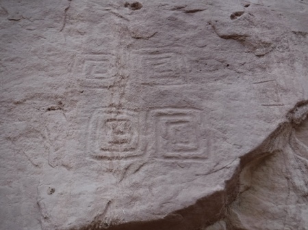
A unique set of four square spiral petroglyphs. Do they represent the seasons? I would be curious to revisit this site during the seasonal changes to see if there are any types of solar alignments.

One thing that struck me this trip beyond all else was the amount of time we spend planning, and where that planning can sometimes get us. Don’t get me wrong- planning can be everything, it can mean the difference between a fun, memorable trip and a disaster. But there are times that planning can get in the way of our adventures. Planning can hold us back, it can hold back the explorer in us and stifle the sense of accomplishment, the sense of discovery that we seek out there in the bush.

We live in an overstimulated world with just too much information flowing around us, in our heads and readily at hand. One of the reasons I go into the desert is to escape all that. And I don’t want to bring along a bunch of data- on anything. I want to walk and see and hear things, feel the sand under my boots or under my bare feet, wonder about what is around the next corner.  I don’t want to look for the next thing I am supposed to find at a certain distance from a certain point. Where is the fun in that? For me, that is too much like everything else in life these days- click a link and it’s all there. That is decidedly not what wilderness is about for me.

white hand pictographs in San Juan county, Utah. Photo by Gerald Trainor.

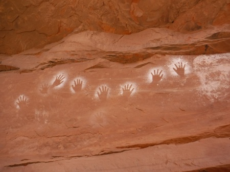
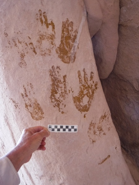
White hands- one of my favorite pictographs, and one of the first I “discovered” in southeast Utah about 20 years ago. I visited them again on this trip.

I have never been one to plan an entire trip, hour by hour, water point to water point, camp site to camp site. I know that people do this. There are guide books that do it for you. This is one of the very reasons I don’t use guide books, other than for very general information. My favorite writer of guides, as I have expressed over the years, is Michael Kelsey. He gives clear, concise, to-the-point information, and not much more. That is all I want- mileage to the trailhead for example, if I don’t choose my own, or maybe data on the best way to climb out of a canyon that everyone says cannot be climbed out of. Kelsey’s books are the place for something like that. After that, it is all up to me.

Moving on from my philosophy of wilderness travel back to civilisation, I always end my trips in Moab. I like to mention my favorite local businesses, in support of the community there. Moab Gear Trader has recently moved into the space above their original store. They have so much used and new gear now that it’s easy to find something you can use. I have an account there, and usually drop gear to sell on every trip. You don’t have to live locally to do this- give them a call to see if they may want your used gear. And if you can’t find what you need there, just down the street is Gearheads, where you will find whatever it is you forgot to bring along. There was a time when I would worry about that piece of gear that I inadvertently left behind, but not any more. Between Moab Gear Trader and Gearheads, I know I will find what I need.

Axe head found in wash in southeast Utah. Photo by Gerald Trainor.

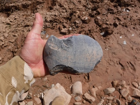
Found in a wash bottom- one large axe head. They artifact had signs that it had been in the wash for some time, and also plenty of use wear. It was made from a perfectly shaped, very flat river cobble.

Gear is good, but we can’t leave out food and coffee to make us happy. Moonflower Coop, on 100 North right off of Main Street, recently completed a major renovation and it is not to be missed. They even  have a seating area now at their deli, where they offer fresh salads, sandwiches, soups, and much more. They are right across the street from Moab Coffee Roasters, one of our favorites. Need a backup bike tube with your coffee? Be sure to visit Moab Classic Bikes on Center Street for both- yes, there is a coffee shop in the bike store. Very convenient!

Our next trip is planned for the end of May- a couple of weeks in the Hanksville area. We are planning, if weather and water levels permit, to walk the Dirty Devil River. No dragging the boat this year! In the meantime, there is plenty more information on desert travels in southern Utah at DesertExplorer.us.


End of Summer Reflection- Canyons, Rock Art, Backroads, and Walled Cities

21 November 2016

It seems that summer has finally ended. We had our first snow of the year in Boulder county last week, signaling the official end of warm weather. It is always a tough time of year when I change from shorts and Chacos into pants, boots, and jacket.  But it is also a time when I look back on the summer that has ended and reflect on all the new things I have seen and the adventures I have had. This year included more time at Nancy Patterson Village, lots of exploration in Montezuma Canyon, a couple of trips into Grand Gulch, and plenty of time in smaller canyons and on dirt roads across southern Utah. More exploration of Cottonwood Wash revealed many ruins, rock art panels, and a few sets of moki steps. One of my favorite “discoveries”, and it may be just that as I have been unable to find references to it, was a series of stone alignments pointing to Spirit Bird Cave. And as always, there was more climbing around in Comb Wash.

Besides indulging in the archaeology of Utah, we did a “side trip” this year and looked at some very different, and more extensive cultural history. Although it requires another post entirely, which may or may not happen, I’ll at least mention our few weeks in Europe in September, most of it in Croatia. In summary: Roman ruins, defensive positions from the time of the Romans, Venetians, Turks, World War II, and the Balkan war of the 1990’s. There was Split, Dubrovnik, Zagreb, and many cities in between, a week on the Adriatic Sea and visits to many islands including the Isle of Vis, which was a partisan stronghold during World War II and was covered with the history and archaeology of the period, not to mention its Cold War history.

Dubrovnik, Croatia- view from wall surrounding the city looking towards the Adriatic Sea.

Dubrovnik, Croatia. Far from southern Utah, but an archaeological and historical dream. This view of the city’s rooftops is from the wall surrounding the city looking towards the Adriatic Sea. Many of the roofs are new- a relative term in a city over 1000 years old- having been destroyed by shelling from the Yugoslav Army and Navy during the siege of the city in late 1991.

Stone Alignments
Back to Utah and its stone alignments. I do not recall having found anything quite like these stone alignments before, at least in this area of southern Utah. Of course that doesn’t mean they aren’t out there.  They reminded me of Mayan roads we often encountered while working in the jungles of Belize; wide, clear pathways with rocks piled along the margins leading off through the jungle. Inevitably the paths led directly to another ruin.  In this case, upon finding the first alignment, I suspected it had something to do with the nearby power lines and the access roads leading up to them. But then I found a corresponding alignment parallel to the first. To make it even more interesting, the next finger to the east had the same alignments, parallel to those on the first. And the third finger, still further east, had more aligned stones, albeit not as neatly done nor as complete as the first two sets. The first two sets had neatly cleared “alleyways” in between the stacked stones, where the stones were likely taken from.

Finally, standing in the center of the alignments looking west brought your eyes directly to Spirit Bird Cave on the rim across the canyon. Not a coincidence, to be sure. And not a “roadway” per se, but more of a ritual or spiritual roadway perhaps, if we accept the importance of Spirit Bird Cave within the context of the local ritual complex.

stone alignment near Sprit Bird Cave, southern Utah. Photo by Gerald Trainor

Stone alignment near Spirit Bird Cave, southern Utah. Spirit Bird is on the canyon rim off in the distance, directly in line with the stacked stones. Spirit Bird is slightly higher in elevation than the mesas the three alignments sit on.


Stone alignment near Nancy Patterson Village, southern Utah. Photo by Gerald trainor.

Same set of aligned stones, looking east toward the second finger of the mesa.


ritual pathways near Spirit Bird Cave, southern Utah. Photo by Gerald Trainor.

Alignment on the second finger, looking west towards the first finger and Spirit Bird Cave. The azimuth of the stones parallels those on the first finger and points directly to Spirit Bird Cave. This alignment had even larger stones than the alignments on the first finger, but not nearly as many stones in total.


Cottonwood Wash
Cottonwood Wash is an extensive drainage covering more than forty miles from the Abajo Mountains until it meets the San Juan River in Bluff. The drainage is rich in many ways- plants, animals, birds, geology, and of course archaeology. Like Comb Ridge, Cottonwood Wash is a favorite “standby” hike for us. During my October trip I hiked the wash a couple of days at a couple of different locations and as always found more than I bargained for. A number of ruins had the most perfectly faced cut stones I have seen in some time. Not only was the facing perfectly flat and smooth, all the exposed stones in the walls were on exactly the same plane. I expected to find the level and string used in building the walls among the pot sherds.

Moki steps, southeast Utah. Photo by Gerald Trainor.

An array of moki steps. For some reason the ancient inhabitants created many ways out of the canyon at this location.

I also happened upon a very large cave with semi-subterranean structures. Unfortunately many of the structures had been dug out by looters, leaving the walls exposed. The cave also contained an array of hand prints- mostly yellow and green, but plenty of red as well.

Yellow hand prints, southern utah. Photo by Gerald Trainor.

Some of the 200 hands in a large cave. Scale is 10 centimeters.


For more on our desert adventures, an introduction to the flora and fauna of Utah, and links to some of our favorite Utah-related books, visit the Desert Explorer website.


Spiders and Beetles, Dalton Wells, Great Horned Owls, and Escalante Photos

8 August 2011

The summer is a busy time for us- busy and fun- and this summer has been one of the busiest in recent years. We have been travelling since March, barely home at all. We’ve seen and done so much that it is hard to keep up with it. This will be a quick post- a follow-up on a couple of earlier posts, and few words about our most recent trip. And as soon as I finish this one, we are off again- we have a permit for the San Juan River next week. Look for a post from that trip in a few weeks time.

Spiders and Tamarisk Beetles
As luck would have it, Nicolai and I found ourselves with some free time a couple of weeks back, and we weren’t too far from Green River Town. We stopped in town for a cup of coffee and some ice for the cooler. Then we made a visit to Crystal Geyser where we had a swim in the still-swift Green River and spent a couple of hours waiting for the geyser to blow. The geyser wasn’t too active, but we did get to talk to a researcher from Grand County who was checking the condition of tamarisk trees and the resident beetle populations. He happened to be checking a group of trees that were covered with those big spiders that we have encountered on our floats down the Green, so we asked for more information about them. He couldn’t tell us specifically about the spiders, but he did say that they seem to be following the beetle populations. It seems that they are feeding on the beetle larvae. He said that in that area in particular he had noted a couple of groves that were covered with the spiders. It seems that the beetles do have a natural, local enemy, a question I am sure that researchers asked when they were deciding whether to allow the beetles to be released.

Unidentified species of spider at our camp at Crystal Geyser. This photo was taken on our float of the Green River in 2009.

Moab and Dalton Wells
On that same trip we made a visit to Moab, as we usually do. This time we did some driving around on roads and trails in the Sovereign area  north of town. One of the entrances to the Sovereign trail is through Dalton Wells, a historic site located just off the highway. It is on the National Register and there is an interpretive plaque explaining the history of the site. Dalton Wells began as a Civilian Conservation Corps camp and was in use for that purpose from 1935 to 1942. It was one of four camps located in the Moab area. The CCC members were responsible for countless projects in the Moab Valley and surrounding area during the years the camp was in operation. These projects were initiated by the Soil Conservation Service, the National Park Service, and what would become the Bureau of Land Management and included building stock trails, water development projects, range improvements, and fencing and pasture work.

From January through April of 1943 the Dalton Wells CCC camp became the “Moab Isolation Center”, one of many relocation camps for Japanese Americans during World War II. The camp was used for this purpose only briefly, and housed “troublemakers” from such camps as Manzanar in California and Gila River, Arizona. At most it housed about 4 dozen men, who were eventually transferred to the indian school at Leupp, Arizona on 27 April, 1943.

There are a couple of websites with more information on the camp- one is the Utah State History website, the other is the National Park Service page on Citizen Relocation Centers. The latter page has a couple of photos of the camp.

Great Horned Owls
In April we made a visit to Phoenix and Tucson where we visited the Arizona-Sonora Desert Museum among other locations. There is  a blog post about that trip for those interested in reading more. In Tucson we stayed in a hotel in the foothills that was also home to a Great Horned Owl and her two young ones. The owlets lived in a large planter box surrounding the deck of a second floor room of the hotel. It appeared that the hotel was respecting the owls by keeping the associated corner room vacant. Our room was right next door to the vacant room and so we had a great view of the owls, day and night. During the day the mother would sleep in a nearby pine tree, up high near the very top. The owlets would huddle together in the corner of the box, as far from onlookers as they could get. At one point the mother brought in a cottontail for the owlets to eat. They moved the rabbit around a bit, and we got to watch one of the owlets have its morning meal. At nights the mother and young ones would perch on the edge of the planter box, keeping a close eye on everything through the night. The mother would fly off and return all through the night, and would leave early in the morning for her daytime rest in the pine tree.

Mother and owlet Great Horned owls at their hotel room in Tucson. Photo by Gerald Trainor.

Mother and owlet Great Horned owls at their hotel room in Tucson. The owlet to the right that is bent over was only concerned with its rabbit breakfast. Most of the rabbit is in the foreground near the cactus.

Owlets in the planter box, Tucson. Photo by Gerald Trainor.

Owlets in the planter box.


Owlets huddling together for their daily rest in the early morning. Photo by Gerald Trainor.

Owlets getting ready for their daily rest in the early morning.

Final Words on Escalante Trip

I have covered nearly everything I wanted to regarding my Escalante Trek in recent blog posts. The only loose end was posting photos of the trip. I have finally done that. A series of photos from the trek is up on the Desert Explorer Picasa page. For more on our desert adventures, desert backpacking, floating and general information, visit the Desert Explorer website.

Escalante Trek, May 2011- Geology, Rock Art, Tracking, and Poison Ivy

8 July 2011

This is the third part of my May 2011 Escalante Trek blog posts. There was so much to see along the way that it was impossible to cover everything in a single post. Part one covered the trek itself, part two was gear reviews. In this post I will touch upon rock art, geology, flora, and tracking practice while hiking. It is a lot to cover I know, and this post will just scratch the surface of these topics. I am still planning a post on Leave No Trace Principles, and probably a separate post on access issues on public lands. I have seen a lot in the news lately- in the Moab, Blanding, and Monticello areas- regarding problems accessing roads and campsites that folks have been visiting for 10 or 20 years. I have had emails regarding the same. It is a topic that demands careful attention, and I will start soon with visits to a couple of BLM offices in southeast Utah to ask some questions. But for now, it is back to the Escalante.

Geology
Whenever I find myself in a canyon I am always captivated by the countless millions of years of geologic history in front of me. And I always wish I knew a bit more about what I was seeing. The Escalante area is no excepotion- it is a geologic wonder. With so many different formations and so much geologic time represented there, volumes could be written on the geology of the area. Oddly, a thorough search of the internet yielded very little information about exactly which formations you are walking through as you make your way down the river, at least if you are a novice geologist. If you can read a geologic surface map, or follow a technical paper written specifically for geologists, then you will find some detailed data available. I had expected to find a geologic map of the canyon bottom for the hiker walking down the river, but found very little other than references to the formations themselves. And those were not specific. So the task remains for a geologically minded canyon bottom hiker to give us such a map. I’d really like to see one.

thin sheet of quartzite material on navajo sandstone slab, escalante river, utah. Photo by Gerald Trainor.

Thin sheet of quartzite, about 1/8 inch thick at most, on a slab of Navajo sandstone along the river. This was a rather common occurrence on the lower section of the river.

From the Moody Canyon trailhead I began my walk in the Wingate and Chinle formations, which apparently dip down and disappear at the river. Most of what I walked through was Navajo sandstone, in the lower part of the river canyon, and up Coyote Gulch.

While I wish I knew more about the specifics of what I was viewing- the depositional environment, the minerals that caused the specific colors, and the events that caused the folding, bending, and dipping- enjoying the imposing beauty of the vertical Navajo sandstone walls, the fluted columns of the Wingate sandstone, or the colorful Chinle shales is usually enough. Not much needs to be said about the Navajo walls- for me they represent the desert canyons with their dark, patinated, vertical walls reaching hundreds of feet high, and the occasional arch such as Stevens arch near the mouth of Coyote Gulch.  

The Chinle formation is one that I have not had much experience with, but on this trip I got to see and feel it up close. On my last day of walking I had to cross through it on my way up and out of East Moody canyon. It was a wet day and the clayey material, revealing ancient swamps and waterways, stuck to my boots, more with every step, until each foot weighed 10 pounds more. But the moisture only added to the beauty- the purples were deeper, the greens brighter, and the extra weight on my feet just added to the adventure.

Another unique geologic feature that I have wondered about for years are “Moqui marbles”. These are round or near-round sandstone spheres varying in size from BB-size up to an inch or more in diameter. I have found them on the mesa top in the Escalante in a few different locations. Don’t confuse Moqui marbles with tumbled sandstone “marbles” found in stream beds. The formation processes for each are completely different. Moqui marbles are formed during the deposition of sand as iron froth-coated air bubbles in very wet sand. Eventually they weather out of the parent material and are found, in the Escalante at least, in large concentrations making their way down gentle slopes.

"Moqui marbles"- ironstone concretions found weathering out of sandstone. Photo by Gerald Trainor.

"Moqui marbles"- ironstone concretions found weathering out of sandstone.

Rock Art
I encountered only a few rock art panels along the river, and a few in Coyote Gulch. As it usually goes, I likely walked by at least as many as I saw. They will be there for the next trip. All of the panels that I saw were small in size and number of elements compared to most panels I have seen both in and out of the area. Perhaps it has something to do with the rough nature of the lower part of the river canyon. The early inhabitants likely chose more hospitable locations for hunting and living and making art, if in fact it was art. Excluding one panel in Coyote Gulch, all were petroglyphs. Coyote Gulch has a few impressive panels, one of which is a pictograph of at least 5 near life-size anthropomorphs. For me, there is nothing quite like finding rock art. And finding life-size human figures staring down at me from a canyon wall, knowing that they have been there for hundreds of years, is really a humbling experience.

A small rock art panel along the lower Escalante River. Photo by Gerald Trainor.

A small rock art panel along the lower Escalante River.

Tracking
Whenever I walk in the canyons I am always on the lookout for tracks. I search them out not only to identify them, but also to follow them. This is how you learn to track- by finding and following them, by reading them, and by building a profile of the quarry you are tracking. On a previous trip in the Escalante, on the upper part of the river, Robert and I made it a point to follow the turkey tracks that we found all along the river. Not only did we practice finding and following the freshest tracks, but after a while we found that the turkeys led us to the easiest paths and around obstacles.

On this trip I found the usual turkey, beaver, coyote, fox, and of course human tracks. Walking along the river margin, in many places there was only a narrow strip of dry land. I followed the tracks of a previous hiker through much of that. It was interesting to see where this person chose to cross the river, when to climb through or over or under obstacles. By following any set of tracks, after a time you begin to build a picture of who or what made the tracks, and you can begin to anticipate their next move. In this case it was a male traveling alone, on the river for days, and with plenty of experience in route finding and canyon bottom travel. Even when I stopped looking for the tracks, I found that I was still following them, that this person and I shared our choices for a route down river.

A Quick Note About Poison Ivy
Poison Ivy is found all along the Escalante River and in many of the side canyons. The river corridor, and the side canyons draining into it, tend to be very wet. They are perfect locations for Poison Ivy to thrive. Keep your eyes open for the stuff- you will find it everywhere there is a constant source of water. If you come down Scorpion Gulch, be especially watchful. The narrows down near the river require either careful wading through the potholes, or more careful squeezing and scrambling along the stream edge. Either way you will be negotiating a Poison Ivy jungle. I have taken to wearing long pants most of the time and also carry a small bottle of Tecnu, a soap made specifically to combat the oils deposited on the skin when you brush against the plant. 

Poison Ivy in a relatively dry location just up Fool's Canyon form the river. Photo by Gerald Trainor.

Poison Ivy in a relatively dry location just up Fool's Canyon from the river. It gets much thicker further up canyon where spring-fed pools of water are common.

For more on the Escalante Region, Poison Ivy and other desert flora, tracking and geology, visit the Desert Explorer website.