Practice Makes Perfect- Making Fire

22 December 2017

My son and I are always testing ourselves, no matter what we do. We make everything we can into a learning experience, do our best to find better ways to do things, and to get better at what we do. It could be a physical test, by turning a 5 mile canyon walk into a 15 mile walk for example. Or a skills test- I might let Nicolai do the packing for a trip, have him navigate and route-find as we hike, or have him get our stove set up or fire made for the night’s dinner.  Making fire is a classic test for us, something we can never practice enough. We use many different methods- a single match, a lighter, a metal match (a rod composed of a metal alloy known as ferrocerium) and tinder, a metal match and magnesium shavings, or a bow and drill. We make it a point to practice all these techniques in varying temperatures, different levels of wind, with different moisture levels, and types of tinder and fuel, essentially training for any possible conditions that we can. This is the way we get better, and master our skills.

Much can be said about fire making techniques and tools- everyone has their favorite methods, and opinions of different methods, not to mention opinions of countless other variables- how many methods you should carry with you, whether or not to carry natural tinder or a commercial variety, a small lighter or a large one, a book of matches or strike anywhere stick matches.  These are all questions that each person has to work out for themselves. No matter how many books you read, how many blogs you visit, or how many Youtube videos you watch,  it all boils down to your skill and comfort levels.  If you can make fire in a few seconds with your eyes closed by rubbing two sticks together, you probably don’t need to carry 3 or 4 different methods with you.  If you have trouble lighting a fire with matches, you should probably have a large, well-stocked fire kit with plenty of redundancy.

fire making methods- bow and drill, metal match, magnesium block. Photo by Gerald Trainor.

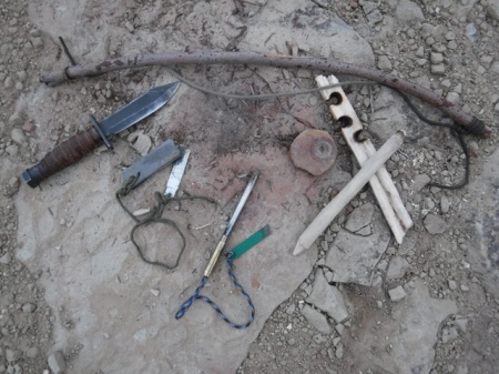
Three fire making methods- bow and drill, metal match, and magnesium block with imbedded ferro rod. No matter what your favorite method, it is important to become proficient. Being skilled in many fire making methods just adds insurance.

Start With the Basics
Fire making, like any skill, begins with practice. Depending on the method or methods you choose, it could be lots of practice. The key is to learn the skill before you need it- practice and become proficient with with the basics first- starting with matches or a lighter, then moving on to the metal match, the fire steel, bow and drill, hand drill, or fire plow. Did I mention you need to practice fire making? And if you decide to carry and use one of the “primitive” methods at the end of the preceding list, you need to practice even more- don’t wait until your life depends on it and assume you can work out how to use a fire steel, flint and charcloth. It may be too late.

Start with considering the placement of your fire- think about where you want to build it. Ask yourself if this is the right place for it now, overnight, and tomorrow. Think about wind and weather, what is overhead (remember the lessons of Jack London!), and if this is where you want to sleep if it is for the night. Consider reflectors, natural and those you put in place. Are there rocks or a rock face to direct the warmth towards you? Finally consider safety, dry grasses and branches for example and Leave No Trace principles.  Try not to build a raging, night-long fire where its existence will be visible for years.

No matter which method you use to get that all-important spark, all fire-starting methods require a tinder bundle for your spark, kindling to build it up, and fuel to feed the fire. Spending the time to create the perfect tinder bundle will insure success. Collecting and preparing kindling and a sufficient pile of fuel for your fire may mean the difference between being warm, and starting over.

Birds nest of juniper bark, photo by Gerald Trainor

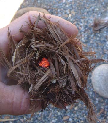
The perfect birds nest with glowing spark from a bow and drill.

Where we operate in the Four Corners region bark from the Juniper is the best tinder available. It is easy to find and remove from any Juniper we  come across. Our second choice is the hairlike, inner material from dry cottonwood bark. Chunks of dry cottonwood bark are usually found at the base of larger cottonwood trees; look for those that have large, dead branches. Either material should be twisted in the hands, or pounded between a couple of rocks to break it up and create the fine powder that is so easy to ignite. Of course there are countless other materials that can be used for a tinder bundle. The idea is to find something that can be reduced to fibers, and pounded nearly into powder. Other desert plants to look at include sagebrush, rabbitbrush, and some grasses if they are fine and very dry. After making your tinder bundle, simply hold your match or lighter underneath, place the spark from your bow and drill or charcloth into the bundle, or direct the sparks from your metal match into the bundle. Once you’ve reached this point the rest is fairly easy- slowly and carefully feed the fire with tinder, kindling and then larger fuel until it reaches sufficient size for your needs.

For more on fire making in general, see our Learning the Basic of Fire page.  Also see our page on the Metal Match and Magnesium Fire Starter. Visit the Desert Explorer website to peruse other skills topics as well as the highlights of some of our adventures.


Back From the Bush, Planning the Next Trip

31 March 2010

It is the time of year when I wish I could just stay over in Utah.  The winter is nearing its end and we are ready to get out. And two weeks is just never enough time, no matter the time of year. Nicolai and I had a great trip though, as always.  The weather cooperated for the most part.  There were a few cold nights, a few cold mornings, and of course the usual strong winds.  Precipitation was very limited- we had a couple of snow flurries that lasted all of an hour at the most, and a couple of light rains that passed in a few hours.

We started our trip as we usually do at our “secret” camp site overlooking the train tracks near Westwater.  From there we made a counter-clockwise loop to Moab, Green River, through the Green River Desert (along the edge of the Green River) to Horseshoe Canyon, Hanksville, down towards Hite, Cedar Mesa, and Mexican Hat, then up through Blanding and Moab back to I-70.

Horseshoe Canyon
We visited some new locations, including Horseshoe Canyon to look at rock art. The panels down there are just amazing, truly some of the best you will ever see.  And the preservation, for the most part, is great.  Nicolai was a bit confused about why there was a chain keeping us back from the rock art at the Great Gallery.  He understands that some people deface the rock art with their graffiti; he is quick to pick it out on nearly any panel.  When I explained that the idea is to protect the panels so that he can come back to see them in 50 years, he kind of felt okay about it.  We sat at the Great Gallery for a couple of hours, taking in the paintings, the clear sky, the trickle of water flowing down Barrier Creek.  We will undoubtedly return there.

The "Holy Ghost" panel, Great Gallery

"Shepherds dancing", great Gallery. Note the animated figures with staffs in the lower left.

Mexican Hat
On many of our journeys to southeast Utah we stop in at the San Juan Inn in Mexican Hat for breakfast. We have  a campsite at the southern end of Cedar Mesa that we frequently stay at, and that puts us only about 1/2 hour away from breakfast at the Olde Bridge Grille.  One of the people working in the dining room is Navajo artist Joey Allen.  We saw some of his prints last year and had hoped to buy one from him this time. Unfortunately he didn’t have any along, but they can be purchased from his website.

Hunting and Primitive Skills
Anyone who has read our blog or visited the Desert Explorer website knows that we focus a lot of our time on primitive skills.  On this trip we experimented with using rice grass for making the birdsnest for starting fires. We used it on many nights with the metal match, and gave it a try a couple of times with the spark from our bow and drill.  It required a bit more striking with the metal match to warm the material up than does Juniper bark for example.  I am sure this is because the material is more coarse.  The grass burst into flames with a couple of blows after dropping the spark from the bow and drill into the birdsnest.

Our fire kit with ricegrass birdsnest flaming.

In our last post we included a photo of a not-so-perfect obsidian knife we had made.  The inspiration for that knife is at the Edge of Cedars Museum in Blanding.  There are four beautiful knives on display there from a cache in nearby Westwater Canyon. They are normally displayed in the “visible storage” area upstairs.  But now they are downstairs in a plexiglass cube as part of a new exhibit, allowing me to get a decent photo of them.

Three of the four hafted knives on display at the Edge of Cedars Museum in Blanding.

Nicolai loves the knives and  we had to go back for a second visit to look at them, and take a few more photos for him, before we could leave Blanding.

We had originally planned to shoot a rabbit or two on this trip.  Nicolai had plans for the meat, as well as the pelts and other parts. But we did not have the best luck hunting during the time we had our license.  We did find tracks and scat, nothing fresh, but no rabbits made themselves visible to us. We did have some fun firing our Ruger 10/22 though.  It was Nicolai’s first time firing it and he loved it.  It seems it will be a permanent part of the packing list for Utah from now on. And we’ll try our luck at finding some rabbits next trip.

He's a pretty good shot, with a little help.

SPOT GPS Messenger
Finally, we did try out our new SPOT.  We sent at least one “okay” message from our camp each night. We sent out our custom message whenever we found rock art or ruins.  I made note of where and when each message was sent. Every message made it through, without fail.  You can click on the links that are sent out and view “road” maps, toppgraphic maps, or satellite maps. From our end on the ground, it took only seconds for the “message sent” light to start blinking.  I was a little skeptical about that, so took notes on each “send”.  I am more of a believer now.  It is a great way to keep in touch and let friends and family know you are on track and okay.  And should you need it, it might save your life. You can read more about the SPOT and how it compares to PLB’s in some of our past blog posts or at the Desert Explorer website.

Our SPOT GPS Messenger connecting with GPS satellites for location information before sending our custom "found rock art" message.

This  post has provided a quick summary of some of our trip. We will post more in-depth soon about the rock art we saw and other locations we visited that might be of interest  to everyone.


Wilderness Kids- Survival Skills for the Four Year Old

24 April 2009

When we go hiking my son carries his own Camelbak with water, snacks, his bird guide and a few survival items including a whistle and a flashlight.  I have stressed to him since the very beginning the importance of being prepared, of having all he might need with him, just in case. As a father I feel one of the most important things that I can do for my son is to teach him the skills to stay alive in the bush. Of course our frequent practice of primitive skills goes far beyond the average person’s idea of being prepared, and of being self-sufficient. For the average hiker these skills are not entirely necessary, to say nothing of the average four or five year old. But it is very important that they know what to do if they become separated from you on a hike.

A note on terminology- I avoid using the term “lost”.  “Misoriented” is a term used in the U.S. Army roughly translating to being lost.  The philosophy is that you never really become “lost”- you are somewhere on your mapsheet and the mission depends on your continuing. “Misoriented” in this context is always proceeded by the term “temporarily”.  There are psychological advantages to never allowing yourself to become “lost”, but rather “temporarily misoriented”, and to teaching this perspective to your child. With that said, I personally have never been lost in my life, and never will be. I stress this point to my son as well.

The Basics of Hiking Together

The following discussion assumes that you are teaching your child wilderness skills as you hike, discussing topics such as trees, plants, rocks, animals, and even the weather.  It is assumed that you are carrying a map and compass, and that you are actively teaching your child about them, allowing him or her to use them as you hike.  Teaching children about nature in general and about maps, about how to find north with or without a compass, and about basic navigation techniques empowers them and will help them develop a healthy relationship with the wilderness. For more on teaching children wilderness skills, see our Wilderness Kids pages.  For more on land navigation see the Maps and Navigation pages at the Desert Explorer website.

The first thing to teach your young one before you ever take your first hike together is to stay close, at least in sight distance.  Children are naturally and healthily attached to their parents- they want to be near us.  They stay close to us at the grocery store, and keep us in sight at the park for example. Hiking in the bush should be no different.  Talk to your children about the potential dangers where you are hiking- this might be a stream, animals, steep slopes, or thick brush where you could be quickly separated.  Explain to them that you are not in your back yard, that they need to stay close, closer than normal- stress the importance, but do not scare them with it.  You want them to enjoy the wilderness, not to fear it.

Each situation will be different, but if my son and I are following a discernible trail, I often let him take the lead. I then have him in sight all the time. If I lead I am constantly turning to check on him.  We often hold hands and walk together on our hikes, taking in the sights and discussing everything we see.

If We Become Separated

Should we ever become separated my son knows what to do.  I have taught him that if he cannot see me, cannot hear me, if I do not answer when he calls for me, that he should find shade and sit down. I have taught him to be calm, have a drink of water and continue to listen and call for me.  In his pack he carries a very loud survival whistle.  He knows that this is not a toy- it is to be used only in such a situation. That is his next step; get out the whistle and blow it at intervals.  This whistle is so loud that there is little chance of me not hearing it.

My procedure is the same if we become separated- I stop and call for him, listen for him, and wait for the whistle. With him stopping in place and sitting down, I am given the advantage of being able to easily follow my backtrail and locate him.  He knows that if he stops and sits down he is making it easier for me to track him.  If I cannot find him on the backtrail, I can find where he wandered off our trail and begin tracking him to where he sits.

Thoughts on Being “Lost”- Panic or Calm?

Panic is the primary danger to people who become misoriented in the bush. Once a person realises they have lost control of their situation, that is, they are lost, a downward spiral can quickly occur.  Stories abound of hikers hundreds of feet from the trail, or a mile from a road, heading off in absolutely the wrong direction, thrashing through the brush, leaving their gear behind, exhausting themselves, and putting themselves in extreme danger.

The thought behind stopping immediately could have saved many hikers from uncomfortable and unplanned nights in the bush, and worse.  When people are lost, out of panic, they often begin to travel aimlessly-  to wander, to cross their paths again and again, or to travel in circles looking for the lost trail or a recognisable feature.  For rescue personnel who might be tracking them this makes the job all the more difficult.

The first thing to remember if you do “become lost” is to remain calm. Sit down, take a drink of water, and relax a moment.  Then consider where you have come from and where you are heading.  If you calmly and logically assess the situation, chances are you will quickly realise where you went wrong.  If you are indeed unable to find your way back, you must remain calm and gain control of the situation. For more information on how to address being lost, and a survival situation in general, see the Survival Kit pages and the Primitive Skills pages at the Desert Explorer website.


Map Reconnaissance- Choosing and Knowing Your Route

12 February 2009

Any fun and successful trek in the bush, whether it be an afternoon walk or a week-long backpack, begins with a thorough study of the map.  It is important to develop an understanding of the terrain you will be walking, for example its elevation changes, possible exit routes in case of emergency, and locations where you might find water.  This knowledge will help you enjoy a safe journey.  The map reconnaissance, or map study, as I present it applies more to a trek in the wilderness than in a national park, where you will follow trail markers and meet other hikers along the way.  Map reconnaissance for a wilderness trek in desert canyons will be my focus in this post.  Since I am currently preparing for a long walk in the Escalante this  summer I will use it as my example in the text.  Please note: the following post assumes the reader understands basic land navigation techniques including a thorough knowledge of map reading.  If you find yourself lost while reading the following please visit the Desert Explorer website and read through the Maps and Navigation pages found there.

Map Study Sequence- Location,  Distance, Entrance and Exit

After I have chosen the general location for a trek, here the Escalante region,  I begin with either USGS 1:100,000 “metric maps” and/or Trails Illustrated maps if they are available for the area.  Note that if you use both the USGS and Trails Illustrated maps that they are different scales.  I use these  smaller scale maps (maps showing a larger area and less detail) to establish a general length for the trek while keeping in mind the time I have available.  I also look for possible entrance and exit locations, where I might be able to drive to the canyon rim for example, and establish a staging area- a “trailhead” of my own. Once I have developed a tentative plan by studying these smaller scale maps I turn to large scale maps with more detail- 1:24,000 topographic maps. This is where the thorough study occurs.  By closely reading the 1:24,000 map I can determine if in fact my trailhead is accesible, if my entrance and exit locations are plausible, and if springs might be located along my route.  Knowledge of terrain features, contour lines, map colors, symbols and scales is necessary at this point.

Distance and Time

When considering hike length and time needed, you must know your limits- your calculations may be different from mine.  I typically allow for between 14 and 20 kilometers, or 8 to 12 miles travel per day.  For me, typical canyon-bottom hiking time is about 3 kilometers per hour at an easy stroll.  So this amounts to between 5 and 7 hours of walking each day.  I often do more than this- sometimes as much as 10 to 12 hours of walking in a day, amounting to as much as 15 miles, or about 24 kilometers.  By knowing my rate of travel, I can create an accurate itinerary through my map reconnaissance.  My times and distances are something I have established for myself over the years.  You will need to establish your own guidelines. And remember that daily distances will vary according to terrain.  The distance covered in a day of canyon-bottom hiking  will vary greatly from a day that includes climbing out of a canyon, trekking across a mesa, and entering another canyon.  That day may be very different in length from a day of road-walking back to your car.

Checkpoints and Daily Goals

How far and how fast I walk depends on many factors which I consider in my map study.  I ask such questions as: where is the next set of ruins I want to visit?  The next water source?  My next camp? The next side canyon I want to explore?  And on the final day, how far is it back to my truck? Answering these questions allows me to establish checkpoints along my route, specific locations that are my goals during, or at the end of each day.  For example, on my coming Escalante trip, I know that day one will be partially taken up by final preparations and travel (hitching a ride) to my “trailhead”- the Highway 12 bridge over the Escalante River.  I should be left with about 6 or 8 hours of good daylight for walking.  I know that Boulder Creek enters the river about 6 miles down.  This is my camp for the night, and if time allows I’ll take a look up the creek a mile or two.  Ten miles further is The Gulch, my goal for day 2. Further down river I will make it a point to camp at the mouths of side canyons that I will do overnight trips in the following day.

Itinerary, Contingencies and Safety

I usually stick to my itinerary, but if there is any question about how long I might be at one location, or when I might arrive at another, I note it and calculate alternative distances based on these options.  I put everything down on paper, including mapsheet names, and if I am on a longer trip copying a smaller scale strip map from the 1:100,000 maps , marking pertinent points on it, and leaving it behind with a responsible individual.  I include phone numbers of local agencies, such as the BLM office, in case I do not return within my alloted time.  In terms of time allotment, I usually allow myself a couple of extra days on a trek of any length, and note that on my itinerary.  It will read something like this: “I should be back at my truck on Friday, but give me till Sunday to call you. If I don’t call on Sunday give me till Monday afternoon before you begin to check on me.”  Leaving an itinerary and contingencies  may not seem important to some, but lives and limbs could have been saved on more than one occasion if people had done so.

For more information on basic navigation techniques, visit the Desert Explorer website and read through the Maps and Navigation pages.


Fire Making, Desert Explorer Updates

18 February 2008

Fire Making

This weekend I continued my experimentation using Cottonwood bark for a fireboard. I have had great luck with dry bark that I have found at the base of larger, older trees. It also provides the hairy inner bark which can be used to create a “birdsnest” for fire making. The “birdsnest” is the carefully constructed bundle of bark which receives the spark created by friction on the fireboard. I had never read of anyone using Cottonwood bark for a fireboard, but I am sure it has been done. Typically the board is created from a piece of Cottonwood branch. So far I have made at least the last 10 or 12 fires using it.

Cottonwood bark is rather soft, compared to a fireboard made from a Cottonwood branch. A 1/2 inch thick fireboard from bark is good for 2, maybe 3 fires per hole. Using the inner bark for a birdsnest to receive the spark is not as efficient as using Juniper bark. My birdsnest was a handful of bark with the pieces being about 1 to 1 1/2 inches long. About a third of the bundle, in the center where I placed the spark and began blowing, was crumbled to dust. All in all it requires more work. In the case of my latest experiment, this amounted to about 5 minutes of blowing and coaxing the bundle of bark into flame. The same can be achieved with Juniper bark in less than a minute. For more information on building fires and primitive fire methods visit theDesert Explorer website.

cottonwood bark fireboard with cottonwood branch drill for bow and drill firemaking kit

The above image shows a fireboard made from a piece of Fremont Cottonwood bark. The drill is from a branch of the same tree. The hole in the fireboard was used to make three fires.

bundles of inner bark from Fremont Cottonwood and Utah Juniper

This image shows bundles of inner bark from Fremont Cottonwood on the left, and Utah Juniper bark on the right. Both are suitable for use as a “birdsnest” for receiving the spark from a bow and drill fireset. The image shows both types of bark without having been prepared for use. The Juniper bark is the easier of the two to ignite.

Desert Explorer Updates

This week I added a Nevada Page to the trip guides. There is very little to it yet, but it has been started. So far I have a listing of places to visit in and around the town of Fallon, in the Lahontan Valley. Fallon is located on Highway 50, south of Highway 80. Some of the listings include directions and particulars on the sites to see. These include the local museum, rock art and archaeological sites, an historic fort and the Stillwater National Wildlife Refuge which offers amazing birding. I will continue working on this page with all the rest.

I have been working on the Backpacking Foods pages. They are coming along, with about 10 recipes so far. These pages seem to be popular, so I will continue adding to them in the near future as well.

I added some explanations and gear links to the Desert Gear pages and the River Gear page.