May and June in Southeast Utah- Nancy Patterson, Amtrak, and Grand Gulch

25 July 2016

We usually make a trip to southern Utah each year later in June, staying into July. This year we planned it so that trip was moved up to late May and into June. It made for more bearable and longer days at Nancy Patterson Village, and easier walking in the canyons later on. Of course there has been another trip since then where we enjoyed temperatures in the high 90’s and low 100’s.  We’ve had such a full summer so far there just hasn’t been time to get to a blog post until now.

Nancy Patterson Village
For the third season we spent a couple of weeks at Nancy Patterson Village doing archaeology. We finished the interior excavation of the room where we began in 2014. We have so much data at this point that it may take us into next summer just analysing and writing it all up. It was our assumption that our unit, being on the edge of the village, was late in date. We confirmed this, and we also confirmed our speculation that the room was built over an earlier midden. Our unit was in the eastern-most room of what I would call a patio group. The approximate size of the group is 13  by 13 meters. It is U-shaped, being open on the east side.
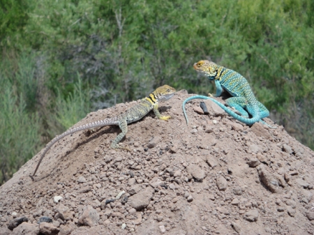
Collared lizards at Nancy Patterson Village. Photo by Gerald Trainor.

Working at Nancy Patterson Village would not be complete without our daily visits from collared lizards. Here a pair watches us from our backdirt pile.

Data collected from throughout the patio group indicate the earliest occupation is centered on the western side, or bottom of the “U”. The latest occupation appears to be our unit, the end room on the northern leg of the “U”. It is likely that the end room opposite us, to the south, is coeval with ours. There are other rooms and room blocks beyond our patio group out in the periphery; isolated rooms, those laid out in a linear fashion, and possibly an L-shaped group. These rooms are all unexcavated and the dates are unknown, but we assume they are closer to the date of our unit which was likely abandoned toward the “very end”, somewhere around the early to mid-1200’s. More about Nancy Patterson will be posted as we continue analysis and writing.
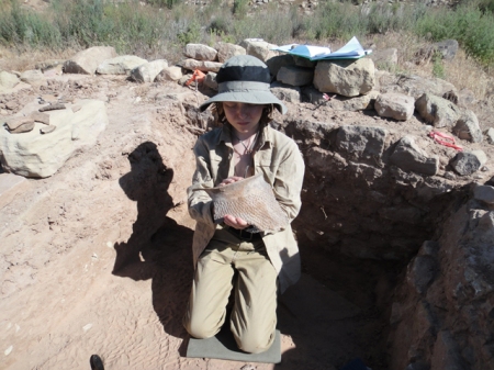
The young archaeologist at work. Nancy Patterson Village, Mesa Verde corrugated sherd being removed. Photo by Gerald Trainor.

The young archaeologist at work at Nancy Patterson Village with a large Mesa Verde corrugated sherd from a post-abandonment artifact concentration just removed.


Amtrak as Part of Our Adventures
After our time at Nancy Patterson Village we had a few relaxing days at a couple of our favorite camps before Nicolai headed home. For those unfamiliar with the area around Interstate 70 north of Moab, a rail line roughly parallels the highway from Glenwood Canyon in Colorado to just past Green River in Utah, where it turns north toward Salt Lake City. The line is used by freight trains and by Amtrak as well. Since we hadn’t been on the train in a number of years, we decided to use it to get Nicolai back to Colorado. We boarded in Green River at about 8 AM and arrived in Glenwood Springs about noon where we met the missing member of our party (mom gets to hold down the fort when we are off in the bush.) The train ride, if there are no long delays, is scenic and enjoyable. You get to see a lot of country along this four hour stretch, and it’s best seen from the observation car. Unfortunately the trip back to Green River was not as quick nor as enjoyable. Just outside Glenwood Springs the train hit a truck which delayed us for about 4 hours. Believe it or not, the driver of the truck crawled out and walked away. The conductors on the train called it miraculous, and likened the train hitting a truck to a semi truck running over an empty soda can. The lesson- be careful at all railroad crossings, especially those without arms that come down to block traffic.

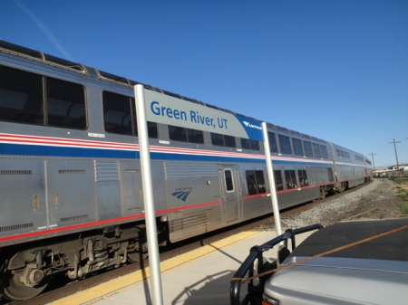
Amtrak train at Green River station, Utah. Photo by Gerald Trainor.

Ready to board, green River station platform.

Grand Gulch
With Nicolai safely back in Colorado I had the next week or so to myself. So it was off to Grand Gulch for some alone time. I hadn’t been in Pine Canyon in some time, so I used it as my entrance. I parked at the drill hole at the end of the road and was in the canyon in no time. It’s a fairly easy walk all around- across the mesa, the climb in, and the walk down to Grand Gulch. I found the canyon very different from the previous trip about 7 weeks before. During our April backpack the canyon bottom was filled with water; we were faced with skirting around pools and hopping across water running down Grand Gulch. This trip, water was barely visible in the bottom of Grand Gulch. There were a few green, debris covered pools here and there that were of course drinkable, but it was like night and day compared with two months before. The weather was warming at this point, and the heat and lack of water ensured that I was the only one in the canyon- I didn’t hear or see anyone on this trip.
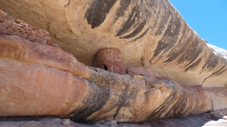
Ruin in Pine Canyon, southern utah. Photo by Gerald Trainor.

Round ruin in Pine Canyon with very interesting architectural change in structure- due to available materials or aesthetics? Note vertical slabs down low, with regular, coursed masonry above.

I could go on as always, but will save it for another post. Next up- more on our new inReach SE, rock art in a boulder field, and parallel stone alignments leading the way to Spirit Bird Cave. For more on our desert adventures, gear reviews, and our archaeological endeavors, visit the Desert Explorer website.


Another Spring Break in Canyon Country

21 April 2016

We have just returned from southern Utah once again. It was a late spring break for us, but well worth waiting for April to make the trip. The weather was perfect right up till the end, when we caught a bit of the storm that brought winter back to Colorado. We spent our two weeks in the usual places, revisited some of our favorite canyons, and explored some new ones. We made it a point to include plenty of time enjoying sunrises, sunsets, and the star filled night sky, and more than a few afternoons sitting on the slickrock with a cup of tea.

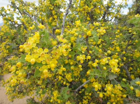
Blooming holly. Photo by Gerald Trainor.

Holly in bloom. The desert was alive with color and fragrance.

Our itinerary brought us straight to southern San Juan county this time. We made an afternoon stop in Moab for final supplies as always, but the weather was so perfect that Moab was too busy for us. April is the perfect time of year for most people- warm days and not too cool nights, without the extreme heat that comes in another month or so. Besides ATV’s and other off-road vehicles, there were mountain bikes everywhere, and more RV’s and camp trailers to be found around every corner than I have ever seen. This was the case everywhere we went- down every road whether it be along Comb Ridge, on Cedar Mesa, or around Green River, where we finished up our trip.

Grand Gulch
We did get a few days of backpacking in this trip. We walked in through Dripping Canyon, had a day in Grand Gulch, and walked out Step Canyon. This is something I have done before, so knew the walk quite well. It was perfect for Nicolai and I- nothing an 11-year-old couldn’t handle. As always, we could have used a couple more days in this short stretch of the canyons- there was just so much to see that we had to choose where to spend our time. For anyone venturing in any time soon, water was not a problem. At least finding drinking water that is. From another perspective, that of walking, it was quite a problem in places. There was so much water in the canyons that we found ourselves skirting pools all along the walk, and especially in Grand Gulch.

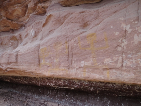
Yellow ancestral puebloan pictograph in Grand Gulch, Utah. Photo by Gerald Trainor.

“Yellow Man” panel in Grand Gulch.

Cedar Mesa was a busy place. The Kane Gulch ranger station was packed on the few occasions we stopped in. But once we got in the canyons we only saw, and heard, one group of people. I should say heard more than saw them. Their presence was known to us by their extremely loud voices, yelling I would call it, and their crashing wildly through the brush. We made it a point to discuss this problem with the folks at the ranger station after our walk- noise pollution is  a problem everywhere and especially in such a place as this. I feel that these days so many people don’t know the difference between a place that is… sacred, and say, the grocery store. The analogy I like to use is that I would not come bounding and crashing and yelling into your church, so please don’t come into mine that way. But I suppose, to continue the analogy, I am preaching to the choir here.

Comb Ridge
We have a favorite camp in view of Comb Ridge making it easy to get into the canyons there. We spent five nights on the slickrock at that camp, really enjoying the night sky. I have to make a plug here for one of my more recent equipment purchases. I have been sleeping better than ever these days on an Exped SynMat 7 Sleeping Pad. This inflatable sleeping pad has an integral pump which inflates it in just a couple of minutes. No blowing it up by mouth involved! I have the synthetic fill version which is rated at an insulation value of 4.9, but there is a higher rated pad that has down filling.  I use it at the truck and on the river- it’s just too heavy for me to carry on a backpack. The pads are not cheap, but if you are struggling with getting a good night’s sleep on a thinner pad, you may want to give one a try.

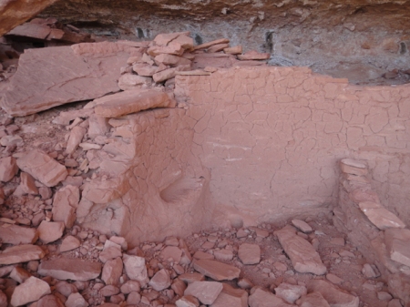
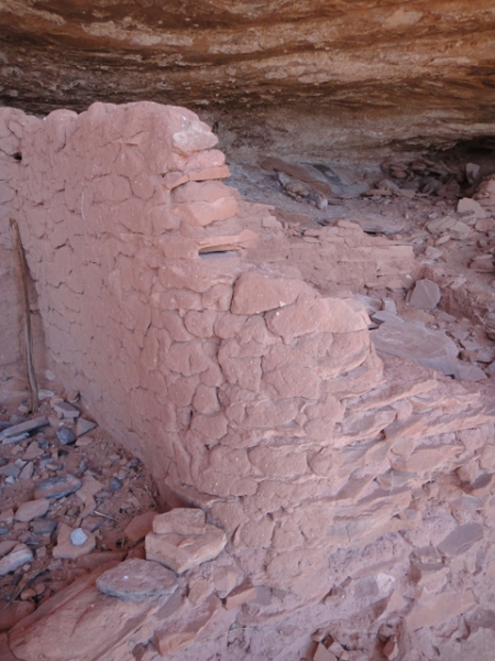
We spent a couple of days exploring Comb Ridge, and as always found more ruins and rock art, middens and moki steps, sweat lodges and seasonal campsites. Comb Ridge is truly a place where one can learn about the varied archaeology of the Northern San Juan region all in one place. One ruin we visited stood out in the amount of mud that was plastered on the walls. The ruin lacked for stone, but still held together well with mud. Looking at it you could see the way it was applied, in great masses, each appearing to be left to sag and dry before the next mass was applied. The interior of the walls had niches built-in, and the end walls were curiously rounded, as if they were not continued across the front, but were left open.

Ancestral Puebloan structure in Comb Ridge, Utah. Photo by Gerald Trainor

Comb Ridge ruin with walls lacking in stone but showing an abundance of mud.

Ancestral Puebloan dwelling in Comb Ridge, Utah. Photo by Gerald Trainor.

End wall of plastered ruin showing rounded finish. Note the thick mortar beds between the thin pieces of sandstone.

There is always so much to see, and to write about afterwards, on our Utah trips. But for now it’s back to preparation for the next trip. In about a month we are back in southern Utah for more archaeology at Nancy Patterson Village. For more about us and our desert adventures visit the Desert Explorer website.


September Trip Report, Part One- Fish Creek Canyon and Grand Gulch

13 October 2012

I was lucky enough to have the last two weeks of September to myself in the Grand Gulch area of southeast Utah this year. I managed to spend about a week in Grand Gulch and on Cedar Mesa, and a few days hiking Comb Ridge. During my hikes I found countless rock art panels- a few that I revisited, but many new ones, and ruins all along the way. I also made a side trip down to Chinle, Arizona for an evening of Navajo singing and dancing sponsored by KTNN, the Navajo Nation’s radio station. The weather was perfect, not too cold, and warm during the day. There was one night and morning of sustained rain while I was down in Grand Gulch. There was enough rain to send water cascading off canyon rims and to turn the previously dry canyon bottom into a fast-moving stream.

My hikes started out with a few days in upper Fish Creek Canyon- 3 days and 2 nights to be exact. I entered from the Fish and Owl trailhead and then walked up the Main Fork and came back down the South Fork. This was a section of canyon I had wanted to visit for at least the last ten years, ever since my first trip into lower Fish and Owl Creek Canyons. The head of the canyon seems very inviting as you drive across it on Highway 95. Looking down canyon, it appears that it would be a gradual, even descent on slickrock canyon bottoms. This is not really the case, especially up high.

Entrance to Fish Creek Canyon, view north from canyon rim after walking across mesa. The walk is rough in the canyon bottom down below.

Since I was traveling alone and not carrying any technical canyoneering gear (no ropes, harness, slings) I started from below and worked my way up. It always feels safer to me to work this way- if I can climb up something I can usually climb right back down it. Coming in from above and following the canyon bottom in an unknown canyon often requires a lot of climbing out- around- back in. This adds the potential for becoming “rimrocked” while trying to find a way back in. Then there is the possibility of downclimbing and coming to impassable pouroffs requiring backtracking and climbing back out. Of course the same will then be true for traveling up canyon, but the potential for getting into trouble is minimised, in my opinion, by traveling up canyon.

Upper Fish Creek Canyon is not lower Fish Creek Canyon, not that lower Fish is that easy of a walk. The canyon started out with water everywhere, and associated brush, requiring lots of skirting of pools, and some climbs around bigger pools at pouroffs. I found pools of hundreds and even thousands of gallons of water on my hikes in Fish Creek, Grand Gulch and side canyons.  I should mention that just a couple of weeks before my arrival there was a tremendous downpour lasting some 10 hours at certain locations. This filled the canyons with water, scouring them out and depositing debris, and creating problems for navigation both in the canyons and on the mesa top. I was told by the rangers at Kane Gulch that “the narrows” of Grand Gulch had become a swimming hole at the bottom, and was jammed with debris at the top. There was a group of volunteers clearing out brush and rebuilding trails in that area while I was there.

Pothole- upper Dripping Canyon, Cedar Mesa, Utah. Photo by Gerald Trainor.

Large pothole holding thousands of gallons of water, upper Dripping Canyon.

Back to Fish- canyon bottom walking was rough at times. Besides water and brush, there was plenty of climbing over, under, and around boulders higher up in the canyon. Slots were a problem higher up, requiring climbing out, skirting on a bench, and climbing back in. The vegetation changes as I gained elevation traveling up canyon occurred in conjunction with the slots- once I started seeing Ponderosa and other pines, the canyon narrowed and started to slot. I encountered more slots coming back down the South Fork than moving up the Main Fork. A rope, harness, and some slings would have made for an interesting experience in these upper sections.  I spent a few hours on benches skirting slots on  the way back down.

Slot in upper Fish Creek Canyon, South Fork. Don’t be deceived by the photo- it is about 40 feet or so down to the water. This would have been fun with rope and harness.

After I finished up with Fish Creek Canyon I headed across the mesa into Grand Gulch proper. I entered via Dripping Canyon, which is passable. That is about all I will say on the subject; it is a fun one, and can be done. I spent the afternoon in Grand Gulch and headed out via Step Canyon, where I stayed the night. Along the way I passed by some of the well-know panels and ruins in the canyon bottom. If you are new to Grand Gulch, it was at one time very populated. This is evident as you walk along the canyon bottom; all you have to do is look up every now and then to see ruins and rock art.

Pueblo dwelling, Grand Gulch, Utah. Photo by Gerald Trainor.

Large, well-preserved, and defensible ruin in Grand Gulch.

Part two of my September Trip Report will cover hikes in Comb Ridge, rock art along the San Juan River, and my visit to Chinle, Arizona. I will also include an update on my tracking book bibliography. Look for that in about a week. In the meantime, for more on visiting southeast Utah, see the Desert Explorer website.


Trip Report- Swell Rock Art, Grand Gulch, and Johns Canyon

12 October 2010

We are back in Colorado after two and a half perfect weeks in southeast Utah. You never know what to expect at the end of September, but we had great weather with unseasonably warm days and nights. The skies were clear,  filled with stars, planets, and a full moon. Temperatures were a warm 85 to 90 or so during the day, dropping to around 50 to 55 at night.

Rock Art and Green River Town
We began our trip by visiting a few rock art panels in the San Rafael Swell area. All the panels are named, quite well known, and are found on most maps. The Head of Sinbad panel, the Lone Warrior panel, and the Black Dragon panel are all rather easy to find and get to, provided you have a four wheel drive, or are prepared for a little walking. All three panels consist of pictographs, with petroglyphs also found at the Black Dragon panel.


Head of Sinbad panel, San Rafael Swell. The detail in this panel is really amazing, the lines are very fine and crisp.


The Lone Warrior panel is as the name implies, a single, isolated image. The pictograph is exposed to sun and the elements and as a result is not as clear as the Sinbad panel.


Along the way we stopped at the town of Green River where they were having their annual Melon Festival. The honeydew, cantaloupe, and watermelon were at their peak of ripeness and sweet and juicy. We also made a visit to Crystal Geyser and spent an afternoon there, alternating between walking through the cold water erupting from the geyser, and then dips into the warmer water of the Green River. There is a new coffee shop in town, right at the corner of Broadway and 150 West- it is a few doors away from the Melon Vine grocery store.  They serve Illy coffee- stop in and support them. See our Desert Links page for more on Green River.

After we left the Green River area we did our usual drive south towards Cedar Mesa with stops in Moab, along the edge of Canyonlands, and in Blanding. Matrimony Spring in Moab is still running strong, and there was nothing in the paper and no talk around town about closing it down again.

Horsethief Road
One important piece of news out of the Moab area had to do with a torrential downpour some time in August. The storm literally washed away the switchbacks on Horsethief road coming up from Mineral Bottom. The road is impassable by any vehicle (even a Toyota Land Cruiser.) It can be walked, and I could portage a mountain bike up through the washed out spots, and get a good workout doing it. According to the Grand Junction Sentinel, the damage is going to cost Grand County about 2.5 million dollars to fix, and it will take about 6 months to do so. The estimated loss in revenue is about 5 million dollars! So if you are still planning a river trip with a takeout at Mineral Bottom, or a ride of the White Rim, you will want to review your plans. See the National Park Service website for more info and great photos.

Cedar Mesa and Grand Gulch
We did a couple of overnight backpacks in Grand Gulch and its tributaries. On our first overnight we walked in on Government Trail and Nicolai finally got to see Big Man Panel, something he was very excited to do. Our next overnight took us down an unnamed canyon at the lower end of Cedar Mesa known locally as Lookout Canyon. This walk is not for the faint of heart or those that are out of shape, especially when it comes to exiting up the left drainage if you do the loop. Be sure to see our Lookout Canyon Dayhike page at the Desert Explorer website for more details on this hike. The hike is certainly worth it if you are up for it. Nicolai enjoyed the solitude, and we entered the canyon the night after a huge downpour, so we were negotiating not only downclimbs, house-sized boulders, pouroffs, and brush, but also pools and potholes filled with fresh rainwater. Red spotted toads were out in force after the rains. It was a great adventure, especially for a 6-year old.


Nicolai sketching the Big Man.


Johns Canyon Bikepacking Trip
Next we drove into Johns Canyon as far as is possible with a full-sized vehicle (Johns is spelled with no apostrophe, this is not a typo). After crossing over the drainage in the canyon bottom and heading south out of the canyon, there is a washout that apparently will not be repaired as it has been there for a number of years now and is just getting worse. It stops vehicle travel altogether, although dirt bikes and possibly ATV’s can get past. From this point we got on our bikes and rode most of a day to an even rougher section of what was once the road to the mouth of Slickhorn Canyon. Nicolai made the decision at this point that we should turn back and camp at a nearby switchback. It was a perfect campsite, allowing us to watch the sun set, then Venus, and Jupiter rise in the east.


Petroglyph in Johns Canyon- man with headdress, over a meter high.


Along the way we saw a number of rock art panels. I am sure we missed a few as well. It seems that this road was also a route used by the ancient inhabitants of the area to reach the San Juan River at the mouth of Slickhorn Canyon. If you do this ride, and plan to go all the way to the river, I recommend not hauling a trailer as we did. Panniers would make the portages through the washouts much easier. Be sure to carry a patch kit and extra tubes!

Unschooling in Southeast Utah
Adventures such as these are a large part of our unschooling experience. Nicolai does not attend school; his learning is largely based on what we decide to do on any given day, and on our travels and adventures, wherever they may take place. Learning for us occurs on many levels, but it is always occurring. For example while on this trip we studied not only the rock art of the basketmaker and Puebloan cultures who inhabited the area, but many other aspects of their cultures such as their technology, farming practices, building methods, food storage and preparation, and hunting strategies.

On our trips we always pay attention to astronomy- the planets and their appearance and disappearance, moon phases, and stellar navigation. On this trip we talked about how our view of the stars and planets differ between the northern and southern hemispheres. We always focus on geology while in Utah- discussing geology there is as necessary as breathing. Utah is a living geology textbook. We incorporate engineering and math into our discussions of ancient cultures, as well as the spiritual aspects of their lives. We discuss military tactics and strategies on our trips as well- Puebloan cultures and their choices for habitation lend well to this topic.  And of course there is the flora and fauna of Utah and our ongoing study of primitive skills. The point here is that learning is not something we do at a desk, and never will be. Learning comes with our daily experiences and we take advantage of every one of them to grow and learn and expand our horizons. For more of our thoughts on unschooling and nature, visit the Desert Explorer Wilderness Kids pages.

Next on the agenda: a trip to the Colorado Canyons. It has been years since I have visited the area, and I have been trying to get back there ever since. A few days exploring Jones Canyon from its mouth is in the works for early November. Check back for more on that trip. See our Colorado Canyons pages for more information on the area.


Utah- June 2010 Trip Report

5 July 2010

We are safely back from another great trip to southeast Utah. We spent two and a half weeks exploring, hiking, finding ruins and rock art, and backpacking. We fought gnats and wind, and had a few cold nights, but the weather overall was cooperative, just cool enough most nights to enjoy a  fire. Fire bans had not yet been imposed, in Utah at least. We even managed a mid-trip blog post from our hotel room in Kayenta, Arizona. You can see that blog post below.

Nightly fire in our fire pan.

We always use our fire pan to lessen the impact we make in the bush. We select campsites that have already been used, and prefer them without piles of blackened rocks filled with half-burned trash. We make it a point to leave our campsites in the same, or better condition. See the Leave No Trace website for more on minimising your impact in the wilderness.

Grand Gulch
One of the highlights of our trip was the few days we spent in Grand Gulch. It turned out to be the hottest few days of the entire trip, with temperatures right at 100 degrees, but we endured and found plenty of water to keep us hydrated. The water was on its way out though, drying up quickly. There were murky potholes at many of the cooler, tighter bends in the canyon bottom, and plenty at the mouth of Water Canyon. Keep this in mind if you are planning a trip into the lower end of Grand Gulch later in the summer.

At the junction of Grand Gulch and Water Canyon- plenty of cold, clean water still there.

We started out from Collins Canyon trailhead and made our way down to Red Man Canyon.  There are a couple of small ruins and amazing rock art in that section of Grand Gulch. As I mentioned in our mid-trip post, I have been down that stretch before, but saw many panels that I had walked right by on my previous trip. I wonder how many more times I can walk it and still see something new?

200 Hands panel- an amazing sight to see. I think there are more than 200, this being just a small section of the 30 meter long panel.

Grand Gulch pictograph

An interesting pictograph found in the main drainage of Grand Gulch.

Navajo National Monument and Betatakin Ruin
After Grand Gulch there was more exploring, including our trip south into Arizona for a few days. We visited Navajo National Monument and did the hike out to Betatakin ruin. If you ever visit that part of the Navajo Nation, be sure to allow time for a visit to the monument. Visiting Betatakin requires about 5 hours or so and must be done with a ranger at the designated times- 0815 and 1000 when we were there. If you have more time the ruins of Keet Seel require a day for the walk out and back. You can do this on your own, after an orientation, and you  can camp overnight at the ruins. The times and days for visiting the ruins changes throughout the year and based on budget, so be sure to check in ahead of time to see what your options are. See the Desert Explorer Navajo National Monument webpage for more information.

The ruins of Betatakin as seen from inside the alcove. Betatakin was occupied only for about 30 years between about 1250 and 1300 .

Newspaper Rock and Other Petroglyph Sites

We also visited Newspaper Rock along the way. The petroglyphs there cover a wide range of dates, from about 2000 years back through historic times. They are very dense, well-preserved, and easily visible on the patinated Wingate sandstone surface. The site is well protected by a fence and appropriate signage. For more on rock art and how to help protect it, visit the Rock Art pages at the Desert Explorer website.

Newspaper Rock, a petroglyph site on the eastern edge of Canyonlands.

Newspaper Rock, a petroglyph site on the eastern edge of Canyonlands.

Sign at Newspaper Rock. It is unfortunate and sad, but some people do need to be told that destroying 2000 year old rock art sites is a bad thing.

Rock art is everywhere in southeastern Utah. All you have to do is look for it, and you will find it. Much of it can be seen along once-ancient, now modern roadways. An example is seen in the image below. This panel, along with a couple of others nearby, has historic Ute elements and prehistoric elements as well. We found it right off the road outside of Bluff and spent some time photographing and sketching the deer, or perhaps elk, in the photo.

Detail of petroglyph panel near Bluff, Utah.

Detail of petroglyph panel near Bluff, Utah.

Moab Area
We spent a couple of days in the Moab area as we usually do. We visited some rock art panels there, including the Gold Course panel. We did some swimming in the Colorado and in Mill Creek, and enjoyed Moab’s great parks and the free internet at the public library. Some good news from the area is that Matrimony Spring is flowing once again. The Times-Independent had an article that said the fate of the spring was still up in the air, then a couple of days later we found the water flowing freely. Someone had placed a piece of flashing under the spring to divert the water for filling bottles. We drank plenty of it with no ill-effects, as has been the case for may years. We have been told that it takes 90 years for the water to get from the top of the La Sals down to the Colorado. That is alot of filtering! Still, use it at your own risk. Who knows what goes on just upstream.

Matrimony spring, Moab, Utah.

Nicolai next to Matrimony Spring outside Moab.


Mid-trip Blog Post- Kayenta, Arizona

12 June 2010

This morning we are at the Wetherill Inn in Kayenta, Arizona. We’ve been out in the bush for the last 10 days and decided to do a hotel night before heading on today to Navajo National Monument. The highlight of our stay in Kayenta was our visit to the Navajo Code Talkers exhibit. It is housed at the Kayenta Burger King, and the Visitor’s center next door. We spent about two hours looking over the exhibit, reading about it, and watching part of a video on the Code Talker program. It is a little-known part of history and will tell you something about the patriotism and fortitude of the Navajo people. If you are interested in World War II history, and you will be in the area, you will not want to miss this. Here are a couple of random links to the exhibit- Roadside America link, Bridge and Tunnel club link.

The weather has been as it usually is in the  summer in the region- sun, sun, more sun, and wind. The temperatures have been hot and the wind has been a constant, ranging from a breeze to gusts strong enough to blow our gear away. The wind has been welcome though, as the gnats up in Utah have been a problem.  We have experienced a change coming down into Arizona- the wind was stronger here yesterday, blowing in a storm. While we saw but a few light cumulus clouds during our time in Utah, yesterday here in Kayenta those few light clouds turned to dark storm clouds. We had a shower in the afternoon and a full-on storm with thunder, lightning and driving rain in the middle of the night. It would have been a fun night to be in the tent!

We stayed at some of our usual camps over the last 10 days, and found a couple of new ones. We did lots of exploring and driving of dirt roads and two-tracks. We found ghost towns, old mines, a historic grave out in the desert, ruins, and lots of rock art. We visited a few rock art sites by truck along the way, and saw countless panels on our 3 days in lower Grand Gulch.

Barrier Canyon style rock art near Thompson Springs, Utah.

We did a 3 day backpack from Collins Canyon trailhead down into Grand Gulch towards the San Juan. I have done it before but, as is always the case, saw ruins and panels that I walked right by before. Visibility changes year by year, and season by season, but also by time of day and direction of travel. For example, walking down-canyon in the morning you might see a huge panel that will be invisible due to the bright sun if you were walking up-canyon in the afternoon. All the more reason to re-visit old hikes and spend more time out in your favorite places! There was water in the lower part of Grand Gulch, though not the cleanest and not as abundant as I have seen it before. The potholes and seeps are drying up and if this continues water will be scarce within the next couple of weeks.

For more information on Grand Gulch and rock are of the region, visit the Desert Explorer website. We’ll be back in Colorado late next week. Look for a more extensive trip report then.


Backpacking in the Escalante and a Grand Gulch Dayhike

26 August 2008

A Few Days in the Escalante

Robert and I spent five days in the Escalante from 17 through 21 August, 2008. Four days were on the trail, the fifth day was at the trailhead camp that turned out to be much nicer than we expected. Our hike took us from the Horse Canyon trailhead down Horse Canyon to the Escalante River. I hiked up the river one day to The Gulch and took a look at The Gulch, about two kilometers up, and a few of its short side canyons before returning the same way. The Gulch was quite choked up, even with the recent rainstorm, and there were no tracks from other hikers visible at all. Our way out was up Horse Canyon to Little Death Hollow for a muddy walk through the slot.

An old cowboy line shack in Horse Canyon, once a train caboose.

Recent rains in the area had washed out roads throughout southeast Utah, including in the Escalante. Luck was with us though, and we were among the first to drive on recently graded roads. We had no trouble at all navigating the roads to the Horse Canyon trailhead. On the way out I drove the Wolverine Loop road back out to the Burr Trail and down the switchbacks to the east. I drove all the way to Bullfrog for (expensive) gas on the backroads. A ranger in the town of Escalante advised Robert that it wasn’t the right time of the year to go down these canyons, that they might be impassable, or choked with underbrush. He even said that the Horse Canyon trailhead afforded no good camping. Our experience was nearly the opposite.

Four days was more than enough for this hike, three would have been adequate. We chose to spend two nights at our camp right on the Escalante River. The river had calmed down by then and the water was running clean. There was no settling of the river water necessary, we just filled our bottles and Dromedary bags and used the Miox to purify the water. We took advantage of the cool water for swimming many times during our two days there.

The narrows of Little Death Hollow.

The hike up the river to The Gulch was interesting. Half of the walk was in the river, the other half following cow trails through shortcuts in the brush as the river meandered beside me.

The walk in the river wasn’t bad, kept me cool and it made me wonder about doing the entire river that way- starting out at the highway bridge north of the town of Escalante and walking down to Coyote Gulch, about 75 miles away.

It would be an interesting way to see the river. If you do any navigating of the river on foot, be sure to bring a solid pair of shoes or boots for wading.

Little death Hollow is a great slot canyon with kilometers of narrows to enjoy. Because of the recent rains it got quite muddy at times. At one point we even climbed out to skirt what appeared to be as much as 100 meters or more of water and choke stones on the canyon bottom. We were prepared for backpacking, not canyoneering, and this seemed to be the safest and most comfortable way around. I will surely return to this canyon for more exploration at another time.

Upper Grand Gulch

After leaving the Escalante I managed to spend one day hiking on Cedar Mesa in the upper end of Grand Gulch. It was a hike I had been meaning to do for years, and with it I have hiked all but about 3 kilometers of Grand Gulch. I parked right at the intersection of Highways 95 and 261 and walked right into the drainage. It took me about 3 1/2 hours to reach the junction with Kane Gulch, about 10 kilometers down canyon. I took a quick look at Junction Ruin, and returned the same way, although I veered west about 4 kilometers from my starting point where a drainage comes in from the west.

Ruin in upper Grand Gulch.

The hike was easy, except for two pouroffs about one kilometer up from the junction with Kane Gulch. One of them required a jump down, and a climb back up. The other I just skirted by climbing through a boulder field. There are at least a few ruins in this part of the canyon that are well worth seeing. The one pictured above, along with another about 500 meters away from it, were built with bright red sand from the wash in Grand Gulch immediately adjacent.  The red sand mortar had stained the stones and both ruins stood out among the deep green of the Pinyon, Junipers, Cottonwoods, desert Aspens, and Mormon tea.  They were easily visible from the canyon bottom below.

For more info on both of these hikes, and others in both areas, visit the Desert Explorer website.


Dirty Devil River, Desert Explorer Update, Four Corners Fugitives

26 January 2008

Dirty Devil River Float-
I made a decision this week to float the Dirty Devil River earlier than I had originally planned. Since I am going to ride the White Rim in August, the plan now is to float solo at the end of May, over the last two weeks of the month. I had thought about floating in August, but was worried about the flow of water then. In May that should be less of a problem. I am giving myself 10 days to do it, but will allow two or three days extra in my itinerary in case I find canyons that must be explored. From all the information I have found on the river, much of it, in the upper reaches at least, seems to be a muddy stream. But I am sure there is plenty to see along the 90 or so miles of the trip from near Hanksville down to Hite. There are some really amazing canyons along the way, judging by the topography on the map. Of course I will carry a pack and hiking gear; I will likely carry a larger pack for an overnight or two if my research and map reconnaissance deem it necessary, and I will make sure they do.

Logistically the only hurdle to work out is a shuttle from Hite to the put-in above Hanksville. I will call Tag-A-Long Expeditions in Moab in the next week or so to see if they have any plans to be in the area at the end of May. It is probably too early for them to know their schedule for sure, but I will let them know that I am interested. Once I park my truck at Hite Marina, and get the ride to the put-in, I am free for the next couple of weeks to explore. I am really looking forward to the float, even though it may be challenging in terms of navigation- dragging the boat across sandbars and through shallows, in the heat of the summer no less, will be a big part of the float from the little I have read about it.

Desert Explorer Website-
I added three new pages to the Cedar Mesa Trip Guides page on the website this week. Kane Gulch Ranger Station to Toadie Canyon Loop; Green House Canyon, Grand Gulch, Pine Canyon, Step Canyon Loop; and Coyote Canyon to Shiek’s Canyon Loop are now online. I will revisit them in the coming weeks to edit and add to the content, and post another photo or two once I locate the images.

I did some editing of the Backpack Foods Page this week, added more content, the first recipe. This page will see more work in the near future as well- I will add at least a few more recipes this week. As with all my pages, I create them and add to them as time allows. My goal is to at least post introductions on the topics that I feel are necessary and important to desert backpacking and hiking. Then I can work on them when I have the time, 10 minutes here, a half hour there. I still have much work to do to get the site to a point that I feel makes it comprehensive. I am about half way to my ultimate goal. So keep checking back.

Four Corners Fugitives Search-
This week I went back to my notes about the Four Corners Fugitives and began work on Chapter Five. It should be ready for posting this week. If you are unfamiliar with this topic, I will offer a summary:

In late May of 1998 a water truck was stolen near Durango, Colorado. Three local men, Jason Wayne McVean, Alan Lamont Pilon, and Robert Matthew Mason were ultimately responsible for the crime. On 29 May the three were spotted in the truck and stopped by officer Dale Claxton. They opened fire on the officer, apparently with automatic weapons, killing him before he could exit his police cruiser. The three then sped off into the remote Cross Canyon area along the border of Utah and Colorado, but not without other incidents. Mason was eventually found dead of a self-inflicted gunshot on 04 June, 1998, 50 miles from where they abandoned their escape vehicle. Pilon was found in the same condition on 31 October, 1999, not two miles form the vehicle. McVean was finally found on 05 June, 2007, just miles from where the truck was abandoned. He had died of a self-inflicted gunshot, probably the very afternoon of his escape.

To read more about the Four Corners Fugitives and the largest manhunt in western history, visit www.DesertExplorer.us .